A 2004 map showing every Richter magnitude 1.5 to 7 earthquake in the Bay Area (67, 750 of them) from 1970 to 2003.
(see maps at the ABAG website
Start with — HAZARD VIEWER but note that it has said: “Note that due to the complexity of the maps, each layer may take some time to load.”
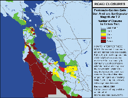
You can find detailed maps (with zoom in capability) of potential road closures, risk of liqufaction and flooding (including if a local dam fails during a quake), such as this map of potential Bay Area road closures after a San Andreas fault 7.2 quake,
Especially useful
–On Shaky Ground– Ground shaking hazard maps for Bay Area cities,
–Preparing for Traffic– maps and safety tips for driving in traffic after disasters
— Hazmat Incidents and Dam Failure– click on the links that take you to dam failure and see if your home could be flooded after a quake
You can type in an address and see (not completely accurately, but roughly) where flooding will occur during/after a Tsanami. (Scroll an look for and click on the Tsunami Hazard Area Maps box.)
After the earthquake you should know how and when to turn off gas, electricity and water.
The PG&E guide with lots of pictures, on how and when to turn off your electricity.
And a PG&E guide to turning off gas
You might want to print and post a copy of these.
The City of San Leandro has extensive material.
(search for earthquake at the San Leandro site)
United States Geological Survey (USGS earthquake hazards info link and USGS earthquake faqs
topics at the USGS site:
Dictionary of Earthquake Terms; Current Earthquake Information;
Common Myths about Earthquakes (including the misguided “triangle of life”, animals predicting quakes, position of the moon and planets);
Earthquakes, Faults, Plate Tectonics, Earth Structure;
Measuring Earthquakes; Seismographs;
Earthquake Effects & Experiences;
Probabilities, Seismic Hazard & Earthquake Engineering;
Earthquake Prediction (with links to a dozen scientific studies);
Historic Earthquakes and Earthquake Statistics;
Nuclear Explosions and Seismology;
Regionally-specific Earthquake Information; Earthquake Preparedness
___________________________________________
Did You Feel It? is a website where you can look to see if that really was an earthquake you felt, and where you can report one. You select from regions: California, Alaska, Hawaii, Western Mountain, Pacific Northwest, Northeast, Central US, Puerto Rico & US Territories, and Other countries.
The site says: “This is a U.S. Geological Survey project to collect information about ground shaking following significant earthquakes. You can help us by filling out a questionnaire for each earthquake you feel. A Community Internet Intensity Map will be made and updated every few minutes following a major earthquake. At first only a few ZIP codes will have intensities assigned, but over time others will be assigned as data comes in. Check back often and watch the maps change!”
______________________________________________
A family (and babysitters, caregivers, overnight guests) disaster plan is at:
Disaster planning
______________________________________________
As a part of preparing for the next earthquake, do a what if? survey of your home, crawl space, attic . .
earthquake home hazards survey
______________________________________________
Helping Children Cope With Disaster
Store water for after an earthquake
Babysitter Consent and Contact Form
Fast, easy, cheap earthquake preparedness
hazardous household chemical mixtures
Earthquake and pets advice (Consider having the vet ‘microchip’ your pets, and more…)
![]()
An earthquake early warning alarm system could give people seconds to ten of seconds warning of a major quake. Transit trains could be stopped, fire and ambulance services alerted, and warnings could be sent to home computers and cell phones in the region. Traffic lights could all be made to turn red, stopping traffic before a bridge or a busy intersection. Nuclear power plants could stop operations and refineries could isolate tanks and vulnerable pipelines. People could duck, cover and hold on instead of being knocked off their feet.
Yes, there could be false alarms, but practice at getting under a desk is worthwhile.
Japan has a working system.
![]()
myths about earthquakes
“The “Triangle of Life” is a misguided idea about the best location a person should try to occupy during an earthquake.”
“Can the position of the moon or the planets affect seismicity? Are there more earthquakes in the morning/in the evening/at a certain time of the month?”
![]()
The author of this webpage, (written as a homework reading assignment for my students), does not give any warranty, expressed or implied, nor assume any legal liability or responsibility for the accuracy, completeness, or usefulness of any information, product, or process included in this website or at websites linked to or from it. Users of information from this website assume all liability arising from such use.