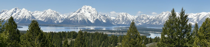
The 5 mile drive up Signal Mountain summit road rewards you with a panoramic view of the entire Teton range, Jackson Lake and most of Jackson Hole, 800 to nearly 1,000 feet above the valley.
From A Place Called Jackson Hole
“People enjoy spectacular views of the Tetons from almost any location in the valley, but Signal Mountain offers one of the finest vistas of the entire valley and surrounding mountains and highlands. To the south, the Gros Ventre and Snake River Ranges enclose the southern end of the valley. Jackson Peak and Sheep Mountain, summits in the Gros Ventre Range, pierce the horizon. The Mount Leidy Highlands enclose the valley to the east. The Washakie Range and Pinyon Peak Highlands form the remainder of the eastern and northeastern boundary of the valley. From another vantage point, the Pitchstone Plateau, one can see beyond Jackson Lake to the north. The Teton Range to the west completes the encirclement of Jackson Hole….From the summit of Signal Mountain, the Snake River can also be seen winding its way through Jackson Hole, coursing down a cottonwood and spruce-lined channel. Directly east of Signal Mountain is an abandoned channel of the Snake, a mute reminder that the landscape of Jackson Hole is dynamic.”
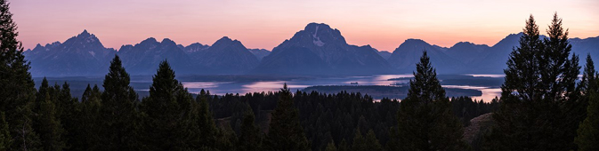
and the NPS also notes: “From the summit of Signal Mountain, the Snake River can also be seen winding its way through Jackson Hole, coursing down a cottonwood and spruce-lined channel. Directly east of Signal Mountain is an abandoned channel of the Snake, a mute reminder that the landscape of Jackson Hole is dynamic. The Snake River is the valley’s only drainage. It begins as a trickle in the Teton Wilderness, flows north into Yellowstone before looping south into the John D. Rockefeller Jr. Memorial Parkway. Enlarged by the Lewis River, the Snake flows into Jackson Lake. The river empties out of the lake at the Jackson Lake Dam and travels southwest, cutting the valley in half. It races out of Jackson Hole through the Snake River Canyon and enters the state of Idaho.”
See below for a description of the drive.
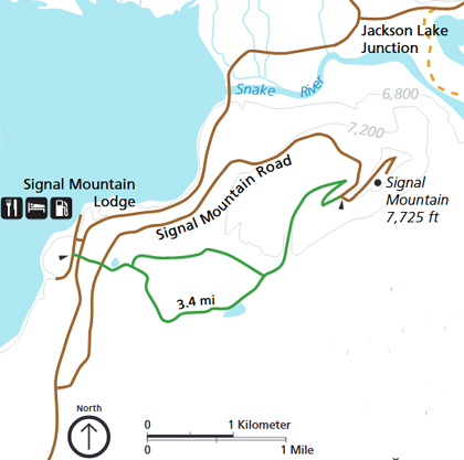
The turnoff to the parking lot and Signal Mountain Road to the summit is one mile south of Signal Mountain Lodge and Campground.
If you go to the summit as a hike, (green line on the map below) you go across the highway from Signal Mountain Lodge and from the trailhead it is a “moderate,” 6.8 mile / 10.9 kilometer round-trip out and back hike with 850 feet of elevation gain.
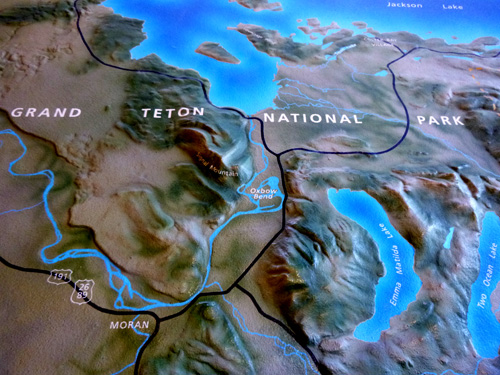
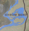
Oxbow Bend is just off this map to the upper right.
Signal Mountain is next to the Oxbox Bend in the center of this raised relief display:
Signal Mountain Campground has 86 (some lake view) campsites.See the map at: Signal Mountain Campground map
Find more info about Signal Mountain Lodge at:Grand Tetons hotels, cabins, lodging
_______________________________________
The drive: no trailers or large motor homes are allowed on the narrow, winding road.
The huckleberries ripen in August, which is when you might see this sign:
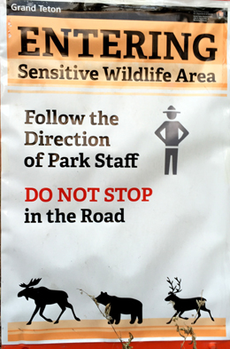
Or you might find the road blocked with cones and a sign saying the road is closed. An example of why the road to Signal Mountain summit was closed, from 2019, was that people were feeding bears and a black bear was bluff-charging people
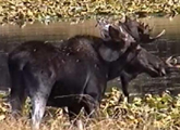
On the right as you go up there is a pond with pond lilies blooming in June and regular sightings of moose munching mostly in the spring / early summer.
Please stay quietly back in the trees and don’t disturb any wild animals. Leave your dog in the car.
The park service reminds us: “If your actions cause an animal to flee, you have deprived other visitors of a viewing opportunity. Use an animal’s behavior as a guide to your actions and limit the time you spend.”
There are two small parking lots near the top of Signal Mountain. The first one, at 7,593 feet elevation, is the one with the view out toward the Tetons (sunset is great there);
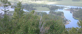
from the second one we can walk a little and look down at Oxbow Bend.
Grand Tetons sightseeing has more info about the area attractions.
Oxbow Bend is a regular destination for our Grand Tetons Kayaking.
You can download a Grand Teton park map
![]()
A larger version of this drawing of the Teton range, with the names of each peak,
as printed in the park newspaper, is at:
See also Grand Tetons and Jackson Lake aerial photo
NASA aerial photo of Teton Range