This page is also a description of various short walkways/trails to the base of Lower Yosemite Fall,
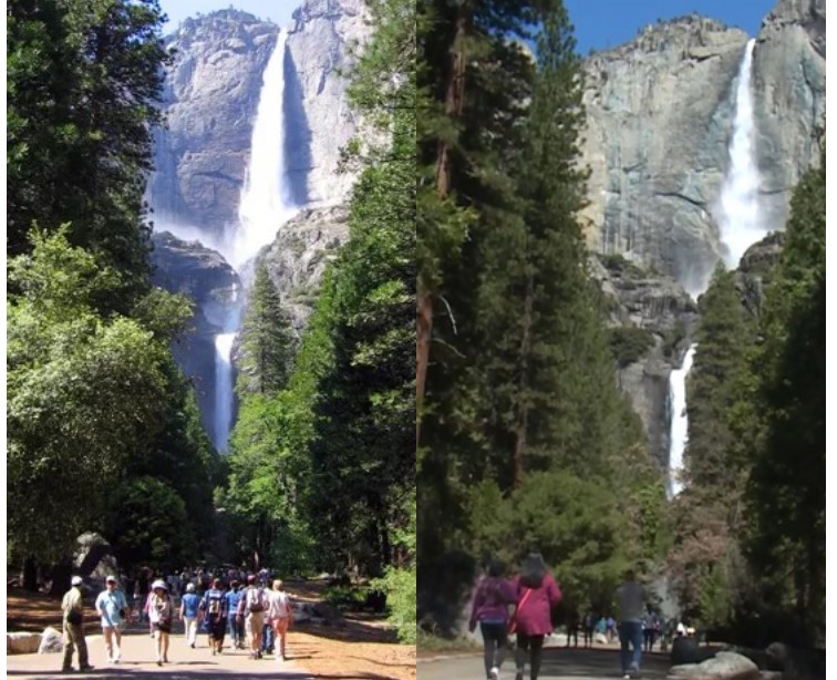
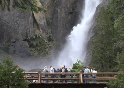
The photos below show crowded and less crowded conditions. If you get up early you can miss the crowds.
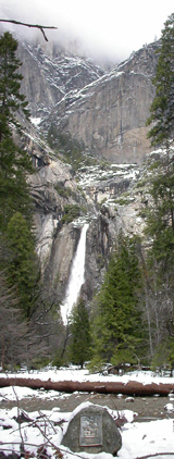
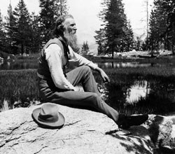
Naturalist John Muir, who “was largely responsible for the establishment of Sequoia and Yosemite National Parks,” built a cabin (wooden shack attached to a sawmill) along the course of Yosemite Creek just below lower Yosemite Fall in Yosemite Valley in 1869 and lived in for two years. In 1903 he camped for three nights in Yosemite with president Theodore Roosevelt and spent much that time shaping the president’s conservationist attitudes.
In 1924 a plaque was mounted on a rock at the site of the cabin.
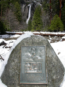
The top of the plaque has an excerpt (in bold below) from this quote in the book Our National Parks, 1901:
“Walk away quietly in any direction and taste the freedom of the mountaineer. Camp out among the grasses and gentians of glacial meadows, in craggy garden nooks full of nature’s darlings. Climb the mountains and get their good tidings, Nature’s peace will flow into you as sunshine flows into trees. The winds will blow their own freshness into you and the storms their energy, while cares will drop off like autumn leaves. As age comes on, one source of enjoyment after another is closed, but nature’s sources never fail. Like a generous host, she offers here brimming cups in endless variety, served in a grand hall, the sky its ceiling, the mountains its walls, decorated with glorious paintings and enlivened with bands of music ever playing. The petty discomforts that beset the awkward guest, the unskilled camper, are quickly forgotten, while all that is precious remains. Fears vanish as soon as one is fairly free in the wilderness.”
But some say that the plaque is at the wrong place. His cabin may have been closer to the lower fall. Look for another plaque on the trail at the base of lower Yosemite Fall with a picture of his cabin:
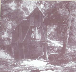
From a letter by Muir:
“I am operating this same mill that I made last winter. I like the piney fragrance of the fresh-sawn boards, and I am in constant view of the grandest of all the falls. I sleep in the mill for the sake of hearing the murmuring hush of the water beneath me, and I have a small box-like home fastened beneath the gable of the mill, looking westward down the Valley, where I keep my notes, etc. People call it the hang-nest, because it seems unsupported, thus:
(he drew a sketch of this cabin)
This photo is of the sketch as recreated in the main Yosemite Village Exploration Center (free shuttle bus stop #5):
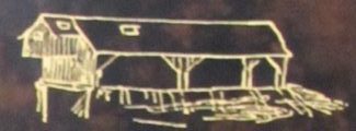
… Fortunately, the only people that I dislike are afraid to enter it. The hole in the roof is to command a view of the glorious South Dome, five thousand feet high. There is a corresponding skylight on the other side of the roof which commands a full view of the upper Yosemite Falls, and the window in the end has a view sweeping down the Valley among the pines and cedars and silver firs. The window in the mill roof to the right is above my head, and I have to look at the stars on calm nights.”
He described a May, 1871 visit by Ralph Waldo Emerson:
“I had a study attached to the gable of the mill, overhanging the stream, into which I invited him, but it was not easy of access, being reached only by a series of sloping planks roughened by slats like a hen ladder; but he bravely climbed up and I showed him my collection of plants and sketches drawn from the surrounding mountains which seemed to interest him greatly, and he asked many questions, pumping unconscionably.”
Elsewhere at the Sierra Club John Muir online exhibit, Muir is described:
“Who was John Muir?
John Muir (1838-1914) was America’s most famous and influential naturalist and conservationist. He is one of California’s most important historical personalities. He has been called “The Father of our National Parks,” “Wilderness Prophet,” and “Citizen of the Universe.” He once described himself more humorously, and perhaps most accurately, as, a “poetico-trampo-geologist-botanist and ornithologist-naturalist etc. etc. !!!!” Legendary librarian and author Lawrence Clark Powell (1906-2001) said of him: “If I were to choose a single Californian to occupy the Hall of Fame, it would be this tenacious Scot who became a Californian during the final forty-six years of his life.”
You can read these books about Yosemite by John Muir for free:
Can I recommend these chapters?
VII THE GLACIER MEADOWS
XII SIERRA THUNDER-STORMS
XIII THE WATER-OUZEL
some favorite chapters include:
Winter Storms and Spring Floods
Snow-storms
Snow Banners
and see a park service page about Muir.
To find the site of the sawmill and cabin, ride the Yosemite Valley free shuttle bus and get off at stop number six, lower Yosemite Falls .
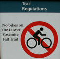
If you are riding your bike, either plan to walk your bike, or bring a lock, as no bikes are allowed on these trails, yes, even early in the morning when you think no one else is around.
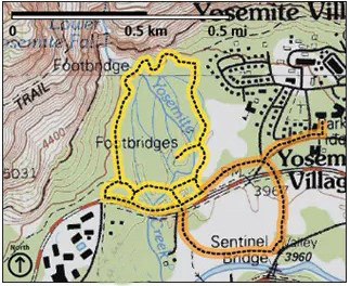
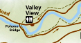
Near shuttle bus stop 6 and at the restrooms a bit up a path to your to your left, you will find a map of the loop trail, or actually more a path/walkway, to the base of lower Yosemite Fall. (Note where on the map it says: “the dotted portion of trial is not wheelchair accessible.” This is because of a short, steep grade near the viewing area, the last 180 feet include a slope of 13.8%.)

In the map, the river is in blue, loop trail is in brown, the bridges over the river are in tan, the main road at the bottom of this picture of the map is in gray. Shuttle bus stop #6 is in the lower right hand corner of the map.
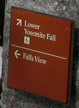
From the shuttle bus stop #6 (with your back to the road) go to your right about 20 yards and then turn left on the well-marked, paved trail. Make a left when you see a stone trail marker with an arrow pointing to the left for Falls View:
Cross a bridge to a spur trail section off the main loop to a spot on the map labeled Galen Clark Memorial Bench. There you will find the plaque, and a bench to sit on and enjoy relatively the same view John Muir had.
For the best walk to the lower Yosemite Fall viewpoint, facing towards a view of the entire falls, go back to the shuttle bus stop and keep walking past it, past the restrooms, and turn right.
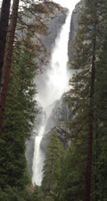
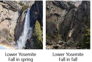
The side by side photos at the top of this webpage are from this far west pathway along this loop trail, (also a direct walk from Yosemite Lodge) with the full view of Yosemite Falls (lower, middle and upper, below in full flow in February 2017).
A larger copy of this photo is at the bottom of this page along with one from June.
I suggest to people that they stop when walking on the pathway to Lower Yosemite Fall, look at the upper fall, imagine it with full flow in the winter and then imagine the wind catching and holding the flow. John Muir wrote about a winter storm when this happened and he counted to 190 before the wind stopped holding the water. Read what he wrote about the experience at:
Upper Yosemite Fall held stationary in mid-air.
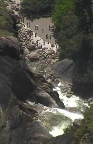
Here is the bridge at the Lower Yosemite Fall viewing area (upper left section of the map above)
and here is the view from up on the trail to the top looking down to the Lower Yosemite Fall viewing area:
![]()
![]()
Please note that the NPS has restrictions on having weddings at many Yosemite locations. The NPS has said ” . . .Ceremonies are not allowed on Yosemite Creek Bridge or base of waterfall . . . Monitoring is required for groups of 50 . . . Wedding permits are not granted for holiday weekends or holidays (Saturday, Sunday, and Monday) . . . “The use of hardy flower bouquets and boutonnières are preferable, to ensure seeds do not fall and germinate. Baby’s breath is prohibited. . .”
If you go early in the day you can miss the crowds as seen in this Google Maps 360 photo.
Yosemite National Park has a webpage about about John Muir.
Here is another map of the lower Yosemite falls loop trail, (in yellow) and the Cook’s Meadow loop trail (in orange) courtesy of the NPS:
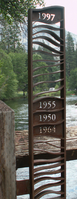
A quick walk you should not miss is in the vicinity. Return to shuttle bus stop number six. Looking across the road you can see a path leading to a bridge (Superintendents Bridge) over the river. When you first step up on to the bridge, on the left hand side, there is a metal sculpture showing the depths of the water various years Yosemite Valley has flooded. It is amazing to stand on the bridge and see when Yosemite valley became a lake. Yes, the entire bridge has been under water at times.
________________________________________________
Another John Muir display many people look for in Yosemite is a sign at a turnout on southside drive where John Muir camped with Theodore Roosevelt. The park service wrote about their camping trip together: “Roosevelt had sent Muir a letter asking to meet him in Yosemite: “I want to drop politics absolutely for four days and just be out in the open with you.” At their meeting, Muir spoke of environmental degradation, like development, and asked for another layer of protection as a national park to improve management. Muir convinced both Roosevelt and California Governor George Pardee, on that excursion, to recede the state grant and make the Valley and the Mariposa Grove part of Yosemite National Park.” This was the start of Yosemite National Park.
This sign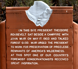 is at a turnout on the right hand side of Southside drive, 0.45 miles east of Pohono Bridge after you enter Yosemite Valley on either 140 or 120.
Southside drive is the lower road on this map. The turnout is just past where the road first goes away from the river after it crosses Pohono bridge:
________________________________________________
Rarely, but sometimes in the winter, portions of the trail to the base of lower Yosemite Falls can be closed due to frazil ice overflowing the bridges. Frazil ice is formed when waterfall mist freezes, and looks like slush on the water of a creek/stream.
Yosemite Nature Notes video about Yosemite falls:
You can set up a photo of getting a drink from the lower fall:
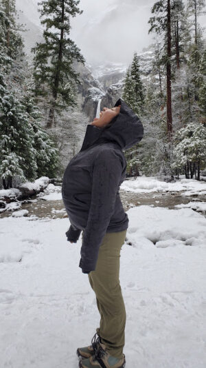
or catching the fall in your hands:
________________________________________________
The trailhead (starting point) for the hike to the top of Yosemite Falls is not in this area. Read Upper Yosemite Fall hike for more info.
________________________________________________
Muir was not the only resident of this area. Archeological work in the Lower Yosemite Fall area proves American Indian use of this part of Yosemite Valley for the last 5,450 years in two large village sites. Indians chose to live on this side of Yosemite Valley because it gets more sun in the winter.
Some visitors in the winter will be surprised to find no snow here, or even anywhere in the valley. Late summer visitors can be dismayed to find no water in Yosemite Falls.
How much water will there be in the Yosemite waterfalls?
________________________________________________
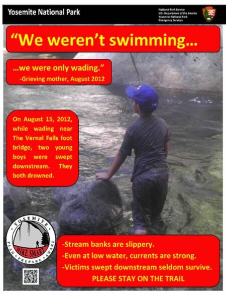
“Choosing to leave the trail and scramble in boulders below waterfalls can have a costly outcome. Is getting closer really worth the risk?”
Four Accidents in four days at Lower Yosemite Fall.
August 11, 2014 From the Yosemite Search and Rescue Blog
“Last week in Yosemite Valley, on four consecutive days, the Yosemite Emergency Communications Center (ECC) received 911 calls for visitors who had fallen and were injured while venturing off trail near the Lower Yosemite Fall Footbridge.
The first incident happened on Sunday, August 3: a 45-year-old male was upstream from the footbridge, standing on a rock, when his foot slipped out from under him and he slid down the face of the rock to the ground. As he slid, he struck his head on the rock, and was bleeding behind his left ear.
On Monday, August 4, a 19-year-old female, while scrambling on a slick boulder at the base of Lower Yosemite Fall, slipped and took a five-foot sliding fall off the boulder; unable to walk, the subject was extricated by a Yosemite Search and Rescue (YOSAR) carryout team. She suffered a trimalleolar fracture (an ankle fractured in three places), requiring surgical repair and will have an extensive period of recovery.
On Tuesday, August 5, a 14-year-old female lost her grip while scrambling on a boulder, slid headfirst down the rock, and injured her left wrist while trying to slow her fall. Although, at the scene of the accident, the subject was nearly certain she had fractured her wrist, no fracture was noted on the x-ray, and she was diagnosed with a severe sprain.
Finally, on Wednesday, August 5, a 45-year-old male slipped and fell while scrambling on uneven terrain not far upstream from the footbridge, spraining his ankle.
After the above-mentioned accidents, yet another occurred on Sunday, August 10. A 26-year-old male was scrambling on the rocks between the footbridge and the base of the waterfall when he slipped and fell, sustaining a large scalp laceration which required repair at the Yosemite Medical Clinic.
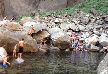
Additionally, earlier this summer, in June, there were two serious accidents in the same area, near the pool at the base of Lower Yosemite Fall.
Although it is not illegal to scramble up to the pool, it is strongly discouraged due to the risk of injury and also for the risk to responders of these incidents. While you may see many people doing this during your visit, please remember how truly dangerous it can be and make smart choices.Even though it is tempting to leave the trail and scramble to the bases of Yosemite’s waterfalls, especially as water levels drop, the boulders at the base of waterfalls are always treacherous. Even when dry, the granite rocks remain surprisingly slick, having been polished smooth by the pounding, falling water most of the year. When rescuers respond to these accidents, even though they are wearing footwear with sticky rubber soles and are experienced in navigating through this type of terrain, they find themselves proceeding with extreme caution.
Enjoy Yosemite’s waterfalls from the safety of the trail, and if you want to cool off in a waterway, choose a spot along one of Yosemite’s rivers where there is easy access (a sandy beach, for example), and where the river is flowing slowly and the water appears calm. Of course, all natural waterways have hidden dangers: strong, unpredictable currents; unseen drop-offs along the river bottoms; and submerged logs and rocks. All children need close supervision by an adult who can swim. If you are an adult who doesn’t know how to swim, do not enter the water!”
PLEASE STAY ON THE TRAIL/BRIDGE.
Suggestions of better places to swim along the river in Yosemite valley are described at Swimming in Yosemite National park
________________________________________________
This walk is on the itinerary of Things to do during a Yosemite snow storm besides hiding in your tent
________________________________________________
________________________________________________
The view of the falls in February from the far left hand portion of the lower Yosemite Falls walkways/trails, an almost straight shot from the Lodge (see second map above):

and a view from June with much less water flow:
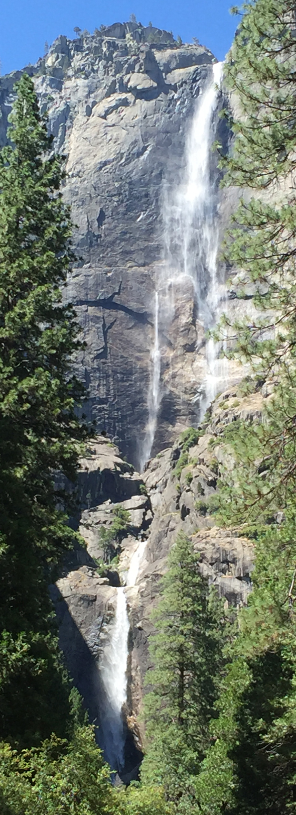
Yosemite Falls, is three falls (three sections), drops a total of 2,424 feet, almost a half mile. Upper Yosemite Fall drops 1,430 feet, Middle Cascades drops 675 feet, and Lower Yosemite Fall drops 320 feet.
________________________________________________
_______________________________________________________
________________________________________________
________________________________________________________________
The author of this webpage, (written for my students), does not give any warranty, expressed or implied, nor assume any legal liability or responsibility for the accuracy, completeness, or usefulness of any information, product, or process included in this website or at websites linked to or from it. Users of information from this website assume all liability arising from such use.