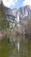
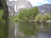
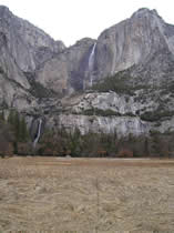
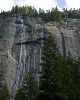
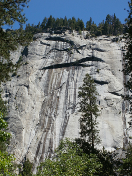
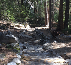
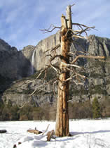
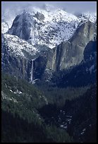
The Yosemite valley waterfalls don’t all always have water all year. Some dry up completely. Their flow depends on the amount of snow, how fast it melts, the drainage of each fall and on occasional rain storms.
The locations of film footage are labeled in each of these videos (courtesy of the National Park Service)
Here is a video of floods in 1996 and 1997, :
and see 2017 flooding:
and 2018 flooding:
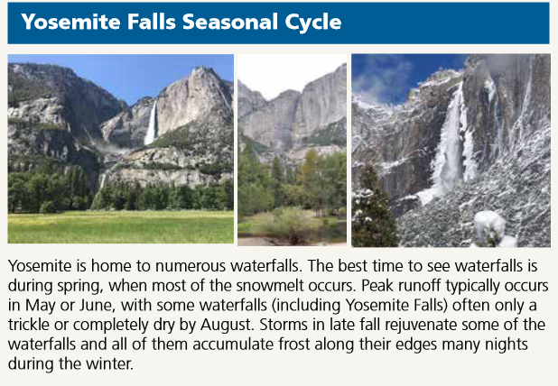
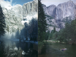
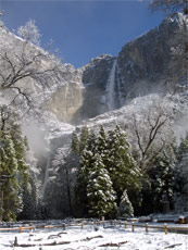
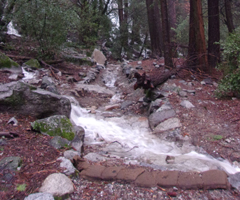
The Yosemite valley waterfalls dry up over the summer and are replenished by fall and early winter rains. A December 4, 2012 volunteer interpreter blog said this:
” . . . Yosemite Falls may have been flowing by Thanksgiving, but it’s not really back until the roar of water announces the return. Strong rainstorms over the past week have brought more than six inches of rain to the lower elevations of Yosemite, making even the smallest drainages fill with the water that flows and tumbles down the Valley walls. The drastic change that Yosemite Falls has undergone in less than one month is amazing, captured in these photographs taken over the past four weeks. . . ”
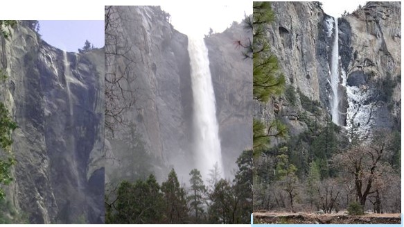
and offered three photos of November waterfall flow:
John Muir described the spring and fall seasons in Our National Parks, Chapter VIII, The Fountains and Streams of the Yosemite National Park:
“In the spring, after all the avalanches are down and the snow is melting fast, it is glorious to hear the streams sing out on the mountains. Every fountain swelling, countless rills hurry together to the rivers at the call of the sun,– beginning to run and sing soon after sunrise, increasing until toward sundown, then gradually failing through the cold frosty hours of the night. Thus the volume of the upper rivers, even in flood time, is nearly doubled during the day, rising and falling as regularly as the tides of the sea. At the height of flood, in the warmest June weather, they seem fairly to shout for joy, and clash their upleaping waters together like clapping of hands; racing down the cañons with white manes flying in glorious exuberance of strength, compelling huge sleeping boulders to wake up and join in the dance and song to swell their chorus…
In tranquil, mellow autumn , when the year’s work is about done, when the fruits are ripe, birds and seeds out of their nests, and all the landscape is glowing like a benevolent countenance at rest, then the streams are at their lowest ebb,–their wild rejoicing soothed to thoughtful calm. All the smaller tributaries whose branches do not reach back to the perennial fountains of the Summit peaks shrink to whispering, tinkling currents. The snow of their basins gone, they are now fed only by small moraine springs, whose waters are mostly evaporated in passing over warm pavements, and in feeling their way from pool to pool through the midst of boulders and sand. Even the main streams are so low they may be easily forded, and their grand falls and cascades, now gentle and approachable, have waned to sheets and webs of embroidery, falling fold over fold in new and ever changing beauty.”
read Our National Parks, by John Muir, at: http://www.gutenberg.org/ebooks/60929
and read Naturalist John Muir on Winter Storms and Spring Floods, Snow-storms, and Snow Banners
in his book The Yosemite at:
http://www.gutenberg.org/ebooks/7091
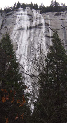
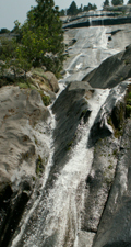
So in August or September Yosemite Falls may be dried up or just a trickle, but Vernal and Nevada will still be falling.
The Bridalveil Fall (height 620 feet) drainage was never scoured by glaciers. We learn in The Waterfalls of Yosemite, by Michael Osborne, that “the watershed of Bridalveil Creek is about 25 square miles in area and largely forested. Because its moderately large watershed has especially deep soils, Bridalveil is Yosemite’s only tributary waterfall that does not become dry. The others usually go dry in the Autumn, but are revived by November rains.”
Here, the forest above Bridalveil Fall:
Bridalveil fall in September, with just a wisp of water, and in February 2017, with full flow: and in December:
The locations to shoot pictures of Bridalveil falls, including the shots above, are at Places to take photos of Bridalveil Fall in Yosemite National Park (with maps)
How much water has been flowing the last few days?
From a November 2025 Yosemite Daily Report:
“River Flows and November Storms
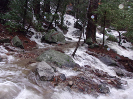
Last week the park received rain and snow from one of the first major atmospheric rivers of the wet season. The rain gage at Yosemite Valley registered 3.79 inches of precipitation, while the Merced River rose over 4ft from below 100 cubic feet per second to 2050 cubic feet per second on November 14 at Happy Isles. The large amount of runoff was due to the warm temperatures during the storm, with temperatures in Yosemite Valley staying around 50F and various snow stations around the park showing the rain-snow line above 8000ft initially. This caused rain to fall on a large proportion of the watershed instead of snow, which ran off quickly in rivers and streams.
These warm winter storms are not uncommon. For comparison, in 1950 the Merced River at Happy Isles rose to 9,260 cubic feet per second on November 18 due to a warm atmospheric river that was the first in a series of three large storms. The park recorded that 26 inches of water flooded the lowest floor of the park superintendent’s house and 55% of the valley floor was inundated.
You can check rain totals in Yosemite Valley here – https://cdec.water.ca.gov/dynamicapp/staMeta?station_id=YYV
To see the water flow at Happy Isles where the section of the Merced River that fills Vernal and Nevada falls enters the valley, click on this webcam link:
http://ca.water.usgs.gov/webcams/happyisles/
You can also find a Weekly Video & Image Archive.
The U.S. Geological Survey maintains stream gages along the Merced River in two locations in Yosemite Valley. The info for today and/or this year, with the median daily streamflow based on over 80 years of record (the little triangles you will see on the chart) is at:
USGS Yosemite Valley stream gages
from the Yosemite Daily Report: “2017 Was A Record Water Year On The Merced River
The total amount of water flowing past the USGS Merced River Pohono Bridge gauge in water year 2017 was the most recorded since gauge installation in 1916 (101 years of record). Flows totaled 1.16 million acre-feet surpassing the previous record of 1.06 million acre-feet recorded in 1983. The water year is defined as October 1st of the previous year through September 30th of the current year. Other large years in descending order were 1995, 2011, and 1969.”
Read about flood recovery at: https://www.nps.gov/yose/learn/management/1997-flood-recovery.htm
– – – – – – – – – – – – – – – – – – – – – – – – – – – – – – – – – – –
How cold is the water in the Merced River in Yosemite valley right now? Scroll down at:
https://waterdata.usgs.gov/nwis/uv/?site_no=11264500
– – – – – – – – – – – – – – – – – – – – – – – – – – – – – – – – – – –
Yosemite Valley spring runoff and flooding / Yosemite snow pack has statistics and links,
including:
The Merced river drainage mentioned below is the water for the Little Yosemite Valley waterfalls, such as Vernal Fall, Nevada Fall and Bunnell Cascade.
Tuolumne River drainage “includes the higher elevation areas of Tioga Road”.
(from the Yosemite Daily Report May 5, 2026) The final snow survey of the season was completed in the May 1st window. The Merced drainage is 20% and Tuolumne drainage is 25% of May 1 average.
Weekend Storm Update (from the Yosemite Daily Report April 14, 2026)
Over the weekend (April 10-12) a storm series generated extensive rain and snowfall in Yosemite. Around 1.5 – 2.5 feet of new snow accumulated in areas of the park above 6000ft, with slightly more accumulation in the northern regions of the park. Yosemite Valley recorded 2.5 new inches of total precipitation during the storm (rain + snow).
Overall, the deepest snowpack recorded in the park is currently in the north at the Slide Canyon weather station, with a total snow depth of 4.5 feet. In Tuolumne Meadows, the total snow depth is around 1 foot, and near Tioga Pass it is about 3 feet. (R. Hallnan)
Winter 2026 Recap + Early Snowmelt and Runoff (from the Yosemite Daily report April 6, 2026)
This winter in Yosemite was mostly warm and dry, interrupted by a few major storms around Christmas, New Year’s, and President’s Day. A record March heatwave drove early and rapid snowmelt, with persistent above‑freezing temperatures causing sharp snow declines in SWE—the amount of liquid water contained in snow—at all Yosemite stations. Snowpack peaked in late February to early March—about a month earlier than the usual April 1 peak—and has since dropped 40% at higher elevations and up to 100% at lower ones. Snow depths are now less than 3 feet almost everywhere, with losses of 2–4.5 feet since late February.
The Merced River at Pohono Bridge reached a potential season peak of 2,930 cubic feet per second on March 21. While another peak may occur as temperatures warm through April, limited high‑elevation snow remains to drive higher flows. A snowmelt runoff peak in March would be the earliest recorded on the Merced River in Yosemite Valley (the second earliest, in 1939, was a full month later). While small weather systems in early April offer some brief relief, the March heatwave, rapid snowpack loss, and early runoff are exceptional in Yosemite’s historical record. (R. Hallihan)
Storm Snowfall Totals – Feb 15-18th, 2026
The latest storm brought around 18 inches of snow to Yosemite Valley, while the park saw surprisingly consistent increases in snow depth in the park’s mid-elevation 7,000-9,000ft band. Tuolumne Meadows, White Wolf, Gin Flat, and Ostrander all received around 40 inches of new snow. At these sites, the total accumulated snow depth ranges from a low of 56 inches at Gin Flat to 91 inches at Tenaya Lake. The Central Sierra has now received 111% of average precipitation for this date (both rain and snow), and total snowpack is around 70% of average.
Final Snow Survey Results (as reported May 7, 2025)
Park staff have completed the final snow surveys for the year, sampling 13 sites throughout the Merced and Tuolumne watersheds. Percentages of water content found the Merced at 62% and Tuolumne of 55% of average.
Monthly Snow Survey Data as reported April 4, 2025
Park staff have recently completed the monthly snow surveys across 13 sites. The Tuolumne Drainage is 72% and Merced Drainage is 75% of average for April 1st. With a warm winter, these averages are being brought down by the lower elevation snow courses which received more rain than usual earlier this winter. These surveys were completed before the early April storms.
March 1, 2025 snow survey
“The Tuolumne Drainage is 66% and Merced Drainage is 57% of average for March 1st. These surveys were completed before the last storm cycle.”
February 1, 2025 snow survey
“Park staff have completed the February 1st Snow Surveys for the State of California Department of Water Resources. In both Tuolumne and Merced drainages, 14 courses are surveyed 4 months of the year. The first of the year’s surveys report the Merced at 25% of April 1st average, and the Tuolumne at 29% of April 1st average. These surveys were completed in advance of the most recent storms.”
April 1, 2024 snow survey
“Park staff completed the April 1st Snow Surveys just before the last storm. The measurements found the Merced drainage at 91% and Tuolumne drainage at 99% of average April 1st snowpack.”
March 1, 2024 snow survey
“Park staff completed March 1 Snow Surveys, before the weekends significant storm event. Measuring 6 locations in Merced drainage and 17 locations in Tuolumne drainage, results show 63% of April 1 average for the Merced and 73% of April 1 average for Tuolumne.”
Snow Survey reported in early May, 2023:
“The final snow surveys for the 22-23 season have been completed by park staff. The Merced drainage is 231% of average (and 189% of April 1 averages). The Tuolumne drainage is 253% of average (and 207% of April 1 averages). It has been a remarkable snow season—thanks to staff in Interpretation, Resources, Protection, BRM, and partners from YC and UC Merced for help completing these important data sets.”
April 1, 2023 Snow Survey
“The Tuolumne Drainage basin average was 244% and the Merced Drainage basin average was 241%. The surveyors determined that at many sites, especially those between 8000-9000ft, this was the deepest snow on record for April 1st measurements. Park staff will complete the final snow survey for the year next month.”
Snow Survey reported in early March, 2023:
“Amidst the incredible storms, snow surveys for the month have been completed. Sampling this month’s window was incredibly challenging, and not all sites were able to be surveyed this month. The Tuolumne Drainage was measured at 186% of average, and Merced Drainage was measured at 160% of average.”
A link in the Yosemite snow survey report to https://cdec.water.ca.gov/reportapp/javareports?name=COURSES (“Data are preliminary and subject to revision.”) showed that Tenaya lake had 142% of normal and Tuolumne Meadows had 192% of normal. (At Lake Tahoe, the Upper Truckee measurement had 358% of normal. At Mammoth it was 224%. The statewide average was 185%.)
First Snow Surveys of 2023 reported in early February.
The Merced River Drainage is at 207%, and Tuolumne River Drainage is at 200% of average for the month of February. Snow Surveys are sampled in 14 locations throughout the park and data is provided to the Department of Water Resource for the State of California.
May, 2022 Snow Survey Results
The Merced Drainage is at 33% and Tuolumne Drainage is at 31% of average snow depth and water content.
April 1, 2022 Snow Survey Results
The water content of the snowpack in both Merced and Tuolumne drainages registered at 41% of average.
March 1, 2022 Snow Survey Results
The water content of the snowpack in the Tuolumne drainage is 65% of average; in the Merced drainage it is 64% of average.
February 1, 2022 Snow Survey Results
The water content of the snowpack in the Tuolumne drainage is 96% of average; in the Merced drainage it is 92% of average.
May 1, 2021 Snow Survey Results
Water content for the Tuolumne drainage is at 25% of average, and at 31% of average for the Merced drainage.
April 1, 2021 Snow Survey Results
Water content for the Tuolumne drainage is at 63% of average, and at 64% of average for the Merced drainage.
March 1, 2021 Snow Survey Results
The water content of the snowpack in both the Merced and Tuolumne drainages is 67% of average.
May 1, 2020 Snow Survey Results
The water content of the snowpack in the Tuolumne drainage is 41% of average; in the Merced drainage it is 54% of average.
April 1, 2020 Snow Survey Results
The water content of the snowpack in the Tuolumne drainage is 46% of average; in the Merced drainage it is 49% of average.
March 1 2020 Snow Survey Results
The water content of the snowpack in the Tuolumne drainage is 34% of average; in the Merced drainage it is 38% of average.
February 1, 2020 Snow Survey Results
The water content of the snowpack in the Tuolumne drainage is 68% of average; in the Merced drainage it is 59% of average.
May 1, 2019 snow survey results
The water content of the snowpack in the Tuolumne drainage is 149% of average; in the Merced drainage it is 160% of average.
April 1 Snow Survey Results
The water content of the snowpack in the Tuolumne drainage is 176% of average; in the Merced drainage it is 153% of average. The storms this year were colder than in recent years, with a deep snowpack at lower elevations. At 7,000 feet, for instance there is approximately 8 feet of snow.
March 1, 2019 Snow Survey Results
The water content of the snowpack in the Tuolumne drainage is 147% of average; in the Merced drainage it is 151% of average.
February 1, 2019 Snow Survey Results
The water content of the snowpack in the Tuolumne drainage is 110% of average; in the Merced drainage it is 93% of average.
May 1, 2018 Snow Survey Results The water content of the snowpack in the Tuolumne drainage is 40% of average; in the Merced drainage it is 39% of average.
As of April 25, 2018 there was no report yet in the Yosemite Daily Report of the April 1, 2018 snow survey results, but this was at http://cdec.water.ca.gov/cgi-progs/reports/COURSES.201804
Tuolumne River Basin
157 Dana Meadows 9,800 26-MAR 76.5 20.0 26% 30.1 66%
158 Rafferty Meadows 9,400 28-MAR 75.0 23.0 31% 32.5 71%
159 Bond Pass 9,300 27-MAR 111.5 29.5 26% 43.7 68%
368 New Grace Meadow 8,900 31-MAR 109.5 42.0 38% 46.6 90%
161 Tuolumne Meadows 8,600 25-MAR 44.5 13.5 30% 22.3 61%
162 Horse Meadow 8,400 27-MAR 100.0 32.5 32% 45.8 71%
163 Wilma Lake 8,000 31-MAR 85.5 35.0 41% 42.9 82%
165 Sachse Springs 7,900 29-MAR 48.5 19.5 40% 36.7 53%
164 Spotted Fawn 7,800 29-MAR 75.0 30.0 40% 44.8 67%
166 Huckleberry Lake 7,800 28-MAR 77.0 30.5 40% 40.4 75%
167 Paradise Meadow 7,650 30-MAR 58.5 23.0 39% 38.6 60%
348 Kerrick Corral 7,000 31-MAR 34.0 14.5 43% 23.0 63%
169 Vernon Lake 6,700 29-MAR 31.0 13.0 42% 21.6 60%
173 Lower Kibbie 6,700 30-MAR 29.5 12.5 42% 24.2 52%
168 Upper Kibbie Ridge 6,700 30-MAR 21.0 10.0 48% 17.8 56%
171 Beehive Meadow 6,500 29-MAR 34.0 16.0 47% 22.2 72%
172 Bell Meadow 6,500 31-MAR 23.0 10.5 46% 14.8 71%
Basin Average Pct. of April 1: 67%
Merced River Basin
176 Snow Flat 8,700 29-MAR 82.0 31.5 38% 44.2 71%
177 Ostrander Lake 8,200 29-MAR 56.0 24.0 43% 33.6 71%
178 Tenaya Lake 8,150 31-MAR 44.0 17.5 40% 31.8 55%
179 Gin Flat (Course) 7,000 30-MAR 40.0 17.0 42% 31.1 55%
180 Peregoy Meadows 7,000 30-MAR 33.5 14.0 42% 27.7 51%
Basin Average Pct. of April 1: 61%
March 1, 2018 Snow Survey Results
The water content of the snowpack in both the Tuolumne drainage and the Merced drainage is is 20% of average. Nineteen out of twenty snow courses were sampled before the recent storm.
February 1, 2018 Snow Survey The water content of the snowpack in the Tuolumne drainage is 25% of average; in the Merced drainage it is 16% of average.
May 1, 2017 snow surveys. The water content of the snowpack in the Merced drainage is 201% of average. The water content of the snowpack in the Tuolumne drainage is estimated at 167-180% of average. The snow pack is heavily weighted toward the higher elevations, with many courses over 200% of their May 1 average.
April 1, 2017 snow surveys. The water content of the snowpack in the Tuolumne drainage is 177% of average; in the Merced drainage it is 168% of average. The snow pack is heavily weighted toward the higher elevations. Below 7,500′ the snow is deep but not exceptional; 143% of average across the park. Above 8,500′ the water content of the snowpack is the highest on record. The snow on the high elevation courses is 10-14 feet deep and contains 5-7 feet of water.
March 1, 2017 snow surveys. The water content of the snowpack in the Tuolumne drainage is 208% of average; in the Merced drainage it is 177% of average. Several courses established new records for both depth and water content. The snowiest course in the park is Grace Meadow, with 16 1/2 feet of snow and over 7 feet of water content.
May 1, 2016 The water content of the snowpack in the Tuolumne drainage is 57% of average; in the Merced drainage it is 63% of average.
April 1, 2016 snow surveys showed water content of the snowpack in the Tuolumne drainage at 89% of average; in the Merced drainage at 91% of average. According to the park “The April 1 survey is considered the benchmark for the year; the water content of the snowpack typically peaks near this date.”
March 1, 2016 snow surveys showed water content of the snowpack in the Tuolumne drainage at 101% of average; in the Merced drainage at 89% of average.
Feb. 1, 2016 snow surveys showed water content for the Merced river drainage at 105% of average and the Tuolumne drainage at 132% of average.
May 1, 2015 snow surveys showed water content for the Merced river drainage at 0% of average and the Tuolumne drainage at 3% of average.
April 1, 2015 snow surveys showed water content for the Merced river drainage at 2% of average and the Tuolumne drainage at 7% of average.
March 1, 2015 snow surveys showed water content for the Merced river drainage at 12% of average and the Tuolumne drainage at 16% of average.
Feb. 1, 2015 snow surveys showed water content for the Merced river drainage at 21% of average and the Tuolumne drainage at 22% of average.
– – – – – – – – – – – – – – – – – – – – – – – – – – – – – – – – – – –
June 7, 2010 the Merced River had it’s highest recorded flow on that date from 93 years of records.
2005 was the 7th wettest season on record for the park (for 4/1). The top six years: 1983, 1969, 1952, 1995, 1978, and 1993.
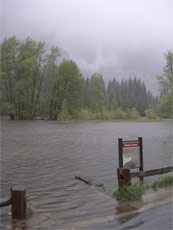
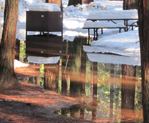
Warm spring weather and rain caused some of the huge 2005 snowpack to flood Yosemite valley on May 16, 2005 and close all roads into and out of the valley for a short time. On May 17, high water levels peaked at about 11 feet, 6 inches in Yosemite Valley at about 5:00 PM.
In the NPS photo of flooded Sentinel Meadow taken May 16, you can just make out the sunken edge of the boardwalk across the meadow between the two posts on the fence and can just see Yosemite Falls thru the low clouds in the background.
Next to it is the same place in June, 2005, and on the right, Feb. 4, 2008.
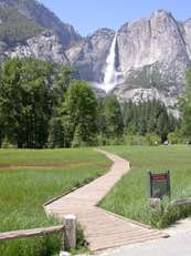
You can see and photograph this view on the Cook’s Meadow hike. You can find more locations to get shots of Yosemite falls, including the ones above, here.
The Merced River, which runs through Yosemite Valley, rose to 4 feet above flood level. Housekeeping Camp, some roads and and some campgrounds had knee deep water and were left with piles of debris to clean up.
The Tuolumne winter Rangers reported: . . . “Just as the rains abated, we observed an ice jam real-time that spanned the width of the river above the bridge on Highway 120. This snow and ice backed up just above the bridge and caused the river to divert into an entirely new channel adjacent to the road. A similar event happened just above the bridge near Soda Spring and Parson’s Lodge. This was an impressive hydrologic event that will probably continue until the snow and ice jams melt out. It remains to be seen if these are new changes in the river course or just isolated until the water levels continue to drop.”
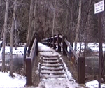
When you first step up on to the bridge, on the left hand side, there is a metal sculpture showing the depths of the water various years Yosemite Valley has flooded. It is amazing to stand on the bridge and see when Yosemite valley became a lake. Yes, the entire bridge, up to and well over the hand rail, has been under water during flooding in 1964, 1950, 1955, and 1997.
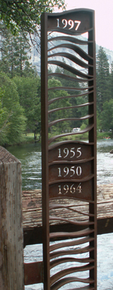
This bridge is on the Cook’s Meadow hike.
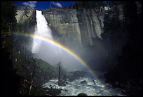
Below: when we hike the Mist trail (one of the routes between Vernal and Nevada) in its mistiest months we like to either wear better rain gear than this, or wear a minimum amount of clothes and plan to get soaked. (But we always bring warm things to put on after.)
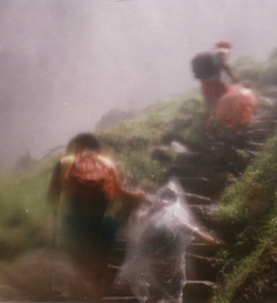
Vernal Fall Mist Trail has pictures of Vernal Fall from the trail, from Glacier Point, Washburn point and from near Clark Point.
To see a 360 degree view of Vernal Fall from near the top of the steps of the Mist Trail, go to
https://www.google.com/streetview/#us-parks-trails-and-beaches/yosemite-national-park-mist-trail
John Muir wrote of a Dec. 19, 1871 storm with “Yosemite rejoicing in a glorious flood.” He counted six falls in the neighborhood of Glacier Point; “between the Three brothers and Yosemite Fall, nine; between Yosemite and Royal Arch Falls, ten; from Washington Column to Mount Watkins, ten; on the slopes of Half Dome and Clouds Rest, facing Mirror Lake and Tenaya canyon, eight… fifty-six falls occupying the upper end of the valley.”
Read the whole text of this chapter ‘Winter Storms and Spring Floods’ from the book The Yosemite
at:
http://www.abovecalifornia.com/lib/JohnMuir/Yosemite/index.shtml
A couple of these ephemeral falls have names:
Ribbon Falls comes down the canyon to the side of El Capitan and becomes a creek through El Capitan Meadow.
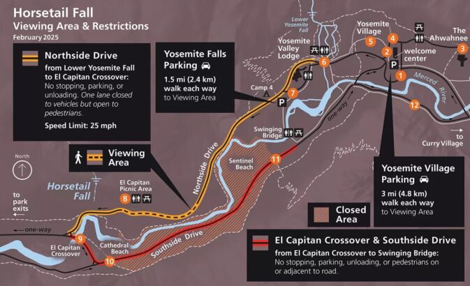
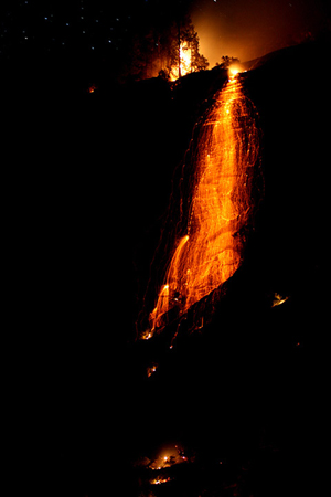
Horsetail Fall, on the east side of El Capitan, (1,000 feet) flows from about December to April, lights up in mid to late February “when the angle of the setting sun sets the waterfall ablaze with reds and oranges, like a fire was falling down the cliffs on the shoulder of El Capitan.” This Firefall comes and goes in roughly only ten minutes. For photos, viewing info and allowed parking:
https://www.nps.gov/yose/planyourvisit/horsetailfall.htm
During the February Horsetail Fall natural firefall, lanes of some roads are closed either to vehicles and/or pedestrians. Road-side parking (parts of both Northside and Southside Drives as well as El Cap crossover) and turnouts, many parking lots and picnic areas are closed to parking, and some years you need a permit to go to where you can see this natural light show.
Watch for signage. Wear warm clothes, waterproof boots, possibly waterproof outerwear and carry a flashlight or head lamp, since your cell phone will not function as a flashlight long enough or brightly enough.
Permit (or no permit, depending on the year)
reservation to enter the park (or no reservation needed, depending on the year)
and parking restrictions/ road closures info for viewing Horsetail Fall, at sunset
(and returning to your overnight accommodation after dark)
are at: https://www.nps.gov/yose/planyourvisit/horsetailfall.htm
including warnings about safety and a larger copy of a map such as this:
Watch a Yosemite Conservancy video of Horsetail Fall.
and Staircase Fall, comes down from Glacier Point to Curry Village (briefly named Half Dome Village), shuttle bus stop # 13b, behind the cabins with bath, and can also be seen from the back lawn of the Ahwahnee, shuttle stop #3.
________________________________________
Yosemite nature podcasts: http://www.nps.gov/yose/photosmultimedia/ynn.htm episode #2 is Yosemite Falls
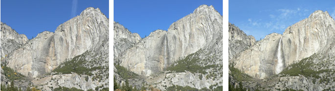
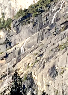
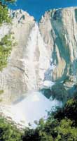
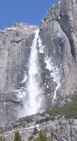
Below: Upper Yosemite Fall in April, 2004, August, 2003 and National Park Service photos of Upper Yosemite Fall in early April, early and mid May, 2003, dried up in September, 2003 and with a snow cone forming Nov. 14, 2004, Dec. 12, 2004, and a snow cone Feb. 11, 2004.
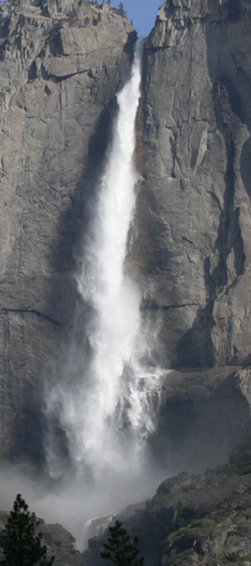
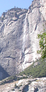
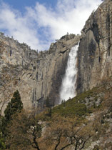
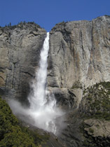
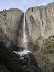
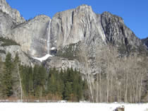
Upper Yosemite Fall drops 1,430 feet, (nine Niagra Falls stacked on top of each other). In the winter the water falling down Yosemite Creek often freezes as it goes over the top, creating a snow cone or ice cone at the base of upper Yosemite Fall.
The Park website tells us: “During winter, sunny days between storms keep the falls in the valley at a trickle; they are transformed into pillars of ice by freezing night temperatures. The Yosemite Falls ice cone forms when water spray, frozen to the granite wall, loosens as it is warmed by the sun and spills to the base of the upper falls.
Water that does not freeze builds up on the cone, and as the temperature continues to rise, the water falls straight into the cone like a reverse volcano. The cone can grow to heights of 250 feet and can cover up to four acres.”
Below: a NPS photo,
In the building of this cone, part of the frozen spray flows directly to its place in the form of minute particles like the dust of wind-beaten snow, but a considerable portion is frozen upon the face of the cliff along the edges of the fall and attains a thickness of a foor or more during the night. When the sun strikes this ice-coating on the cliff it is cracked off in large masses and built into the walls of the cone, while in windy, frosty weather, when the fall is swayed from side to side, the whole surface is drenched, dinding the whole mass of loose blocks and dust firmly together. While in the porcess of formation the surface is smooth, and pure white, the outlines finely drawn, the whole presenting the appearance of a beautiful crystal hill wreathed with clowds of irised spray, with the fall descending into the heart of it with a tremendous roar, as if pouring down the throat of a crater.”
Ice also builds up overnight at the edges of the falling water. You will need to get up early to photograph this. NPS photo below:
Webcam of Yosemite Falls https://www.nps.gov/customcf/webcam/dsp_webcam_image.cfm?id=81B464F7-1DD8-B71B-0BE08AC5151D73F6
https://www.nps.gov/media/video/view.htm?id=EA81A54A-CB4D-410C-6BCB1393E86F108A
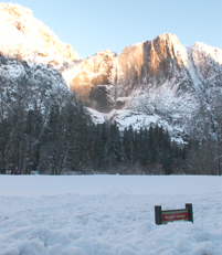
Below: the line on the sign next to Superintendents Bridge in the upper right of this photo shows the water depth during the January 1997 Yosemite valley flood:
Below, awhile after an April sunrise, the sun just starts to touch the cliffs of Royal Arches Cascade.
and in full flow during rain storms in February 2017:
Compare the photo above to April 2017:
And with the heavy rains falling on already deep snow in early February 2017, many of the Upper Pine campground campsites flooded and most parking spaces were ponds. At one point one and a half loops of normally open campsites in Upper Pine campground were closed.
There was toooo much snow at the ski resort so it closed for awhile also.
he notes that “Yosemite Creek is the largest stream flowing into the north side of Yosemite Valley and probably entered the pre-glacial Merced River canyon through a steep side ravine.”
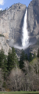
Yosemite Falls: 2,425 feet (with its three sections, it makes up the tallest waterfall in North America)
Upper Fall: 1,430 feet
Middle Cascade: 675 feet
Lower Fall: 320 feet
Bridalveil Fall: 620 feet
Ribbon Fall: 1,612 feet
Vernal Fall: 317 feet
Nevada Fall: 594 feet
Illilouette Fall: 370 feet
Silver Strand Fall: 1,170 feet
Sentinel Fall: 2,000 feet
Horsetail Fall: 1,000 feet
A National Park Service photo of Yosemite Falls on Jan. 14, 2004
http://www.nps.gov/yose/wilderness/traildescriptions.htm
(Backpackers should always check with the Rangers before going out to verify if streams are still flowing, or on the other hand, if trails are safe from water flow.)
Yosemite nature and photography links has the links to birding, geology, wildflowers info previously at this page as well as moonbow or lunar rainbow info.
https://yosemite.org/webcams/half-dome/
At this site you can become a member of the Yosemite Conservancy (formerly the Yosemite Association) and get 15% off on books, postcards, etc. at the Yosemite (and most other National Parks) visitor centers.
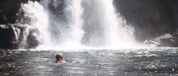
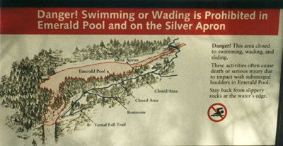
Swimming or wading above waterfalls is dangerous. Almost every recent year someone, or even more than one person, has been swept over a Yosemite waterfall. Some people just got too close trying to get a picture. Others climbed over protective railings/fences.
Look at:
fatal, near fatal or close call incidents/accidents in camping, backpacking, climbing and mountaineering for details.
Below, a warning sign above Vernal Fall.
http://www.nps.gov/yose/photosmultimedia/ytp.htm click on Beautiful but Deadly
_____________________________________________
_____________________________________________
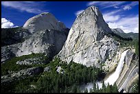
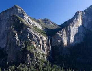
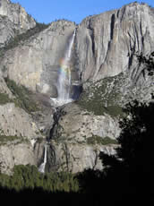
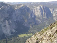
Bridalveil Fall and Nevada Fall
photos by Quang-Tuan Luong/terragalleria.com, all rights reserved.