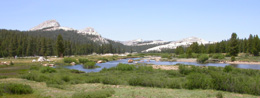
Here, a map of highways 120, 140 and 41 as they come into Yosemite National park:
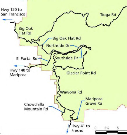
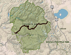
here, a map showing Highway 120 going through Yosemite National Park
(aka Big Oak Flat Road and Tioga Road on the map above). This section of 120 is closed in the winter, usually from sometime in November through late May or early June.
This webpage is some advice about driving to Yosemite from Silicon Valley via highways 580/205/120 for the De Anza College Outdoor Club trips to Tuolumne Meadows.
Should you choose to visit the valley on the way and/or use highway 140, (99/145/41) take a look at Snow camp carpools and driving directions
Some tips for the 580/205/120 route:
trying to shortcut through Livermore on 84 can take more time at stoplights than the longer route of 680 to 580
after Altamont Pass, leave 580 and get on 205,
205 joins 5 for a brief way, then head on to 120,
go past Manteca and on to 99 north using a left lane split,
and look for the next quick exit east on 120.
Most of the rest of the route will be on slow roads rather than freeways, some of it through towns that really want you to do the posted speed limit.
In Oakdale you will make a left turn at a light to continue on 120 east. At Yosemite Junction you will make a right (no light or stop sign in your direction at this intersection).
For the section between Don Pedro Reservoir and Groveland, use Priest Grade, DON’T try OLD Priest Grade. If it is at all hot weather, turn off your air conditioner as you drive the eight miles, sixty curves and switchbacks of Priest Grade, even if your car is in great condition. Don’t turn the air conditioner back on right away when you get to the seeming top at Big Oak Flat. There is still some steep uphill through Priest Station. At the elevation 3000′ sign more typical mountain down and up hill starts.
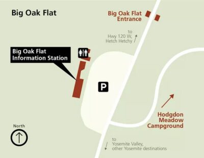
There is a visitor center with a relatively large parking lot and restrooms on the right just after the Big Oak Flat entrance station.
Crane Flat Campground will be on the right 9 miles after the entrance station before you get to Crane Flat.
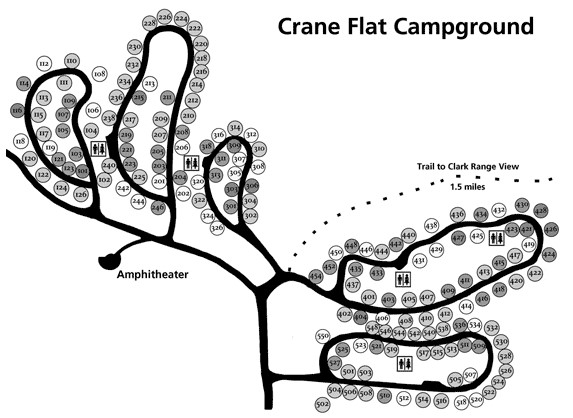
You might want to top off your tank at Crane Flat as the station at Tuolumne Meadows is gone. There is a one way road/driveway into the Crane Flat station. After hours you can (usually) pay at the pump with a credit card.
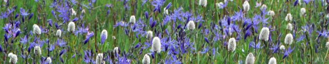
Here are some of the wildflowers (Camas and Western Bistort) you might see in bloom at the Crane Flat Meadow:
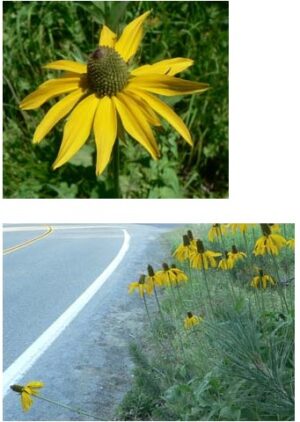
In late June to July, maybe even August or September in heavy snow years, you will also see yellow flowers with petals that droop downward at the top of 3 to 6 feet tall stems blooming in the Crane Flat area meadows. These are Coneflowers. Look closer in these meadows and find Shooting Stars, Monkeyflowers, Forget-me-nots, Deers-tongue, Yampah (lacy white flowers on almost leafless stems 1 to 2 1/2 foot tall, which are not really Queen Anne’s Lace, but sometimes called that) and Corn Lilies (up to 6 feet tall) in season. See: Tuolumne trip wildflowers.
Are we there yet? Not quite, it’s forty miles from Crane Flat to Tuolumne meadows and you will want to make stops and sightsee.
On the left shortly after Crane Flat is a small parking area for a short hike to the Tuolumne Grove of giant Sequoias.
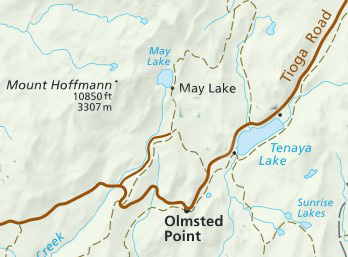
If you have the time, stop at road marker T11, the Clark Range view, and see if you can spot Mount Hoffman to the east (10,850 feet elevation), our potential hike destination. As you drive, also see if you can spot the roadside marker T21, the turnoff down a dirt road to the trailhead for May Lake and Mount Hoffman.
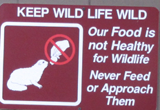
Please do the speed limit. 15 bears and countless other animals were hit by cars in Yosemite National Park in 2005 and unfortunately even more many years since then.
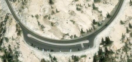
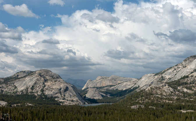
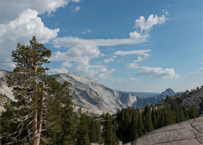
Once you are near Tuolumne Meadows, even if you think you are running late, watch the map and the roadside markers for road marker T24 for Olmstead Point on the right.
Pull into the big parking lot for at least a short stop to look around.
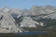
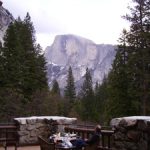
Stop and get out of the car for a look at a different angle at Half Dome than you may have seen, the wide expanse of Clouds Rest and down to Tenaya Lake in the other direction. With a telephoto (photo below) spotter scope or binoculars you can see people going up the Half Dome cables.
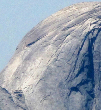
See also more places to take a photo of Half Dome .
Below: photos of Tenaya Lake from Olmstead Point and the view from Olmstead Point with Cloud’s Rest (left) and Half Dome
A National Geographic video of President Barack Obama’s 2016 visit includes segments taken from the shore of Tenaya lake and from Olmstead Point with Cloud’s Rest and Half Dome
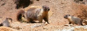
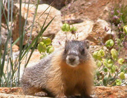
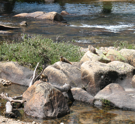
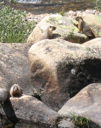
Wander around the area and you may see, in season, Paintbrush and Mountain Pride Penstemon up closer than you did driving along the road. This might be a place you’d like to come back to for sunset. Sit still a ways from other people and you might see animals, like this marmot family:
The sandy soil at the parking area often has Pussy Paws blooming, a circle of bright green leaves surrounded by a circle of little round fluffy hot pink flowers (okay, an umbellate cluster). Due to changes in water pressure, the stems rise during the day and lower at night. Later in the summer the pink flowers will turn brown with hundreds of tiny, black seeds for chipmunks to eat and spread, planting even more Pussy Paws.
Pussypaws, Cow Parsnip, Coneflower, Penstemon, Phlox, Columbine, Monkeyflower, Sulphur Flower, Iris, Groundsel and Lupine Tuolumne trip wildflowers
Google maps 360 degree view of Tenaya Lake, and another view.
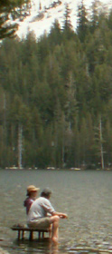
Stop just down the road at Tenaya Lake if you want to try a swim before coming to the campground. (Please don’t risk swimming alone, there are no lifeguards on duty.) The parking lot, restrooms and sandy beach are at the far end of the lake as you approach Tuolumne.
Google maps view of the beach end of Tenaya Lake.
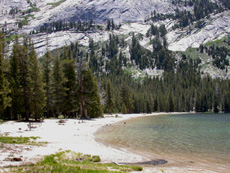
Early in the spring/summer when the water level is high, there isn’t much beach and a few of the picnic tables can be submerged:
From the lake it’s 7 miles to Tuolumne Meadows. The road was built for wagons in 1883 and rebuilt for autos in 1961. In 1911 J Smeaton Chase described the condition of this section of road he used as a trail: “The Tioga road…is a rough track built in historic days by the owners of the once famous Tioga mine… For purposes of technical control a wagon is still driven over it once a year by an adventurous teamster.”
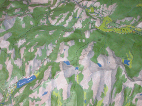 In this section of the raised relief map at the Tuolume Visitor center you can see Tenaya Lake in the bottom left and the meadows in light green the upper right.
When you get to Tuolumne Meadows the meadow itself will be on your left.
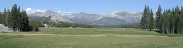
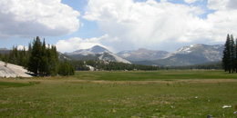
The first dome on the left at this end of the meadow is Pothole Dome. (Some of the glacial polish on this dome is fluted instead of flat (planar) and was not made by glacial debris, but by water flowing beneath the glacier. Hence the name subglacial water polish). It’s a much easier walk to the top than other hikes we have planned, with a good view, but if you go there from the road, please don’t wear out yet another trail across the meadow, use the slightly longer one that runs around the edge.
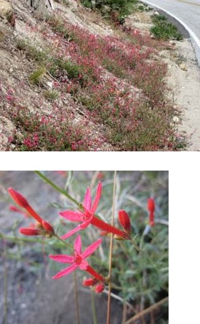
Early in the spring /summer season while the meadow is still wet or even flooded, Shooting Stars (with 4 or 5 pink petals coming from a yellow base, arranged like the wings of a diving bird) will be blooming,
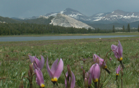
then as the meadow dries up a little, the crimson/magenta Penstemons bloom, and finally the tall red-orange shafts of Paintbrush.
Wander along the river and stay quiet and still for awhile and you might have the chance to see a Marmot family:
![]()
Drawing below courtesy of NPS:
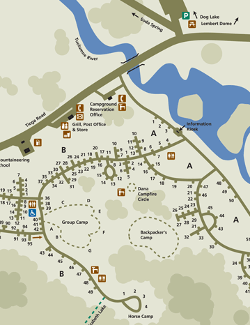
Map below courtesy of NPS
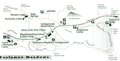
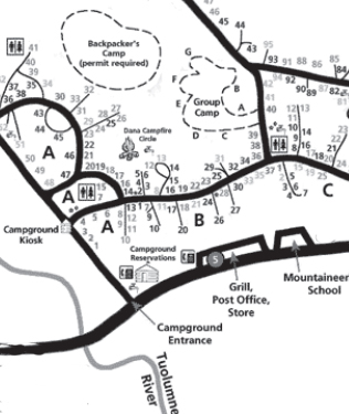
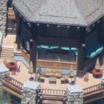
You will be driving in from the left to right on the map above. On the right you will pass (in this order) the Visitor Center (with nature displays and restrooms), trailer dump station, a bit later … (the gas station in Tuolumne Meadows is permanently closed and the nearest gas stations are Crane Flat to the west and Lee Vining to the east), slightly after that… a big white tent
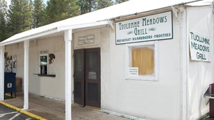
that houses a small grocery/dry goods store (left hand door in the picture above) with a large supply of frozen treats, boxes and boxes of cookies/crackers and a tiny supply of fresh produce- bring your own produce supply, 2016: banana 49 cents, 16 oz strawberries $4.19, 2 lbs grapes, $6.25
the Post Office (center window) and
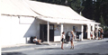
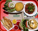
grill (right hand door) … usually 8 a.m. to 6 p.m. (Early in the season sometimes only open for lunch). Great shakes and/or frosties depending on the year (but sometimes the machine freezes over), great fries/potato wedges, burgers – OK breakfast – . Menu: https://www.travelyosemite.com/media/820316/grill-menu-tuolumne-meadows-lodge.png
At the store the restrooms, picnic tables, a climbers’ info display are off to the right of the grill picture above.
(2016, 2017, 2018 and . . . ) Many Sundays at 9am in the Tuolumne Store parking lot, the American Alpine Club and Yosemite Climbing Rangers offer free Climber Coffee. Bring your own cup and get questions answered, share tales.
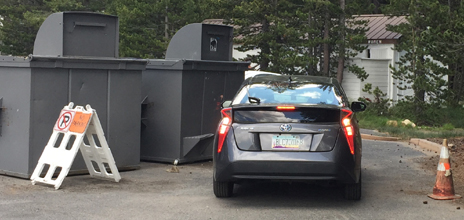
The parking lot is often full, so campers would be wise to walk to the store and other visitors who drive should be patient for a parking space in the lot or nearby to open up. Did this driver from Arizona move the no parking a-frame sign over, or was it already moved over and he choose to ignore the sign, red cone, “No Parking” in large letters on the pavement and two giant trash dumpsters?
Next you’ll drive past (again, on the right) the campground reservations office with payphones (a small stone building), then the entrance road to the campground. (10 mph in the campground.)
The Park Service is doing ongoing work at Tuolumne Meadows.
We read:
“Tuolumne Meadows Campground Closed Until 2024 or 2025
A major project to rehabilitate the Tuolumne Meadows Campground
https://www.nps.gov/articles/000/gaoa-tuolumne-meadows-campground.htm
is underway. As a result, the campground will be closed until 2024 or 2025 (depending on length of construction season, weather delays, etc.). No camping of any kind will be available at Tuolumne Meadows during this time. The backpackers campground will also be closed.
What will be different when the campground reopens?
• Improved and simplified road system
• Rehabilitated restrooms, with two new restrooms added
• Redesigned campsites with hardened parking pads
• Seventeen campsites relocated from along the river and within the floodplain in A loop to an area away from the river (no change in the total number of campsites in the campground)
• Backpackers campground relocated within the campground to the John Muir Trail trailhead
• Twelve walk-to campsites (with nearby parking)
• New picnic tables, food lockers, fire rings in each campsite
• Improved accessibility for people with disabilities, including at the Dana Campfire Circle
• Updated water and sewer system”
Past these the main road crosses a bridge (lots of swimming holes and rock slabs to sun on just upriver) and with Lembert Dome on the left, the highway bears right slightly and starts to climb to Tioga Pass.
To the right there is a side road to the backpacker’s permit/ wilderness center. It has a large parking lot (with lots of metal lockers to store food / ice chests from bears) that people in small carpools or who drove by themselves can park at. (Parking at campsite(s) is limited.)
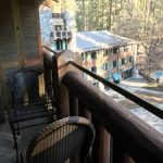
Up the side road a little more past ranger offices / housing is a trailhead parking lot and finally the Tuolumne Meadows Lodge, (mostly guest parking only) with canvas tent cabins. There is a great cascade a short hike up river from the Lodge (the Lodge tents are on the left side of the river as you go upstream, the trail thru the forest is on the right). There are huge bushes of lupine in season.
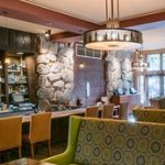
Meals are served at the Lodge in another big windowed tent with watercolors/oils on the walls.
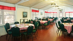
Please verify the following before the trip if you want to partake: breakfast 7 a.m. to 9 a.m. The usual breakfast items including pancakes, eggs/potatoes/meat and some healthy choices.
Dinner from 5:30 (or some years 5:45) p.m. to 8 p.m. (Reservations for dinner strongly recommended or some years required (209) 372-8413 or see the front desk). Dinner is usually a semi-family style meal. Everyone shares 6-8 person tables with whoever arrives/has reservations at the same time. We have been seated with some other interesting backpackers or with a family with noisy ill-mannered children.
For dinner people order from a small choice of vegetarian, steak, chicken, pasta, fish, side orders, many with the salad of the day. Usual beverages and a choice of freshly baked deserts.
Tuolumne Lodge MENUS (including how to order a box lunch for the next day): https://www.travelyosemite.com/lodging/dining/tuolumne-meadows-lodge/
The Lodge is a “smoke free environment”.
The lodge often closes earlier in September than the campground.
Google maps 360 degree view.
includes work to move shoulder parking along the Tioga Road at Tuolumne Meadows . . .” into expanded parking areas within nearby upland areas. The current roadside parking negatively impacts the visitor experience by blocking views of Tuolumne Meadows. Additionally, vehicles encroach into meadow and riparian areas, negatively impacting critical meadow habitat.
The new expanded parking areas will accommodate the same number of parking spaces removed from the roadside along with regional transit buses and other oversized vehicles.”
A Department of Transportation Tuolumne Meadows Parking Project Description website at:
https://flh.fhwa.dot.gov/projects/ca/tuolumne/
has more details, “Construction Date: Spring 2020 – Fall 2021.”
and a link to the map of Tuolumne Meadows showing the locations of parking projects in red, as shown below:
![]()
The drive from Tuolumne Meadows to Yosemite valley is listed by the NPS as 1 hour 30 minutes (55 miles/89 km).
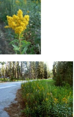
Along the drive you might see Goldenrod and California Cone Flower (Rudbeckia californica) blooming in August.
Possible delays due to road work are at: http://www.nps.gov/yose/planyourvisit/roadwork.htm “Work is subject to change due to traffic incidents, weather, availability of equipment and/or materials, and/or construction-related issues. Please drive carefully and watch for warning signs, workers and equipment in the roadway.”
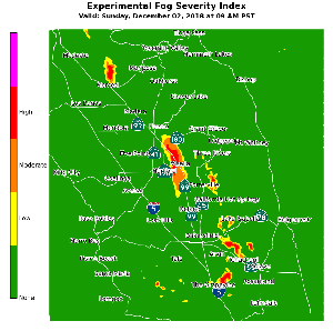
The National Weather Service has a map of predicted fog severity at:
https://www.weather.gov/hnx/HNXFogSI.html This below is not the current one, but just an example and the one at the webpage is much easier to read:
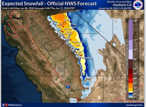
The National Weather Service has an expected snow fall map at: https://www.weather.gov/hnx/winter
The one below is not current, but is offered as an example:
Just before you leave, call 1 800 427-7623. It is voice activated, so say 140 or 580/205/120 or whatever highway number for road conditions, detours, etc. The Yosemite road and weather phone message is 1 (209) 372-0200.
CALL the road info number before you leave town, and perhaps again during your drive!
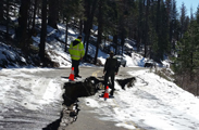
Besides rock slide closures, hazardous tree removal or road paving may be planned along your route.
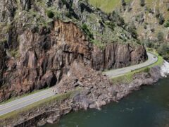
Below rockfall during a January storm:
![]()
and the slide on Highway 140 that closed it starting in March 2025, then became one way with traffic control:
The Park service has noted: “drivers are reminded of the greater likelihood of encountering rock debris on park roads during wet weather. Although rockfalls are always possible along all park roadways, they tend to happen more often during winter storms. . .
If you encounter small rock debris on the road, drive through the area (do not stop within the debris) and promptly report it to Park Dispatch. Do not attempt to remove the debris yourself – leave that task to road crews equipped to do so safely. If you encounter large rock debris on the road, turn around and promptly report it to Park Dispatch.”
Having a at least half full gas tank gives you a better opportunity to turn around and take another route if you do not find out about a road closure before you leave town or if it becomes closed when you are already on your way to the park.
A rockslide also closed 120 for a day and then for about six weeks for repairs in 2012.
In winter 2017, highway 120 was closed for weeks. A March 2 news release said: “Significant rain and snow this winter has saturated the soils, resulting in movement under the road bed. This soil movement has caused a large fissure to form in the roadway that has resulted in both lanes of traffic being unsafe for vehicles. Soils under the road continue to move, causing further damage. Over 100 feet of road, near the Big Meadow Overlook, has been impacted by this fissure. There is no estimated date for the road to reopen.” An April 5 news release said: “Severe winter storms that have given new life to an underground spring caused saturated, heavy soils under the road to slide downhill. Over 200 feet of roadway has been impacted.”
– – – – – – – – – – – – – – – – – – – – – – – – – – – – – – – – – – – – – – – – – – – – – – – – – – – – – – – – – –
The road through Tuolumne Meadows is closed in the winter, you can only ski in. The Tuolumne Meadows campground reservation office for the spring, summer and fall months becomes the Tuolumne Meadows ski hut in the winter. The Tioga road opens mid May to late June, and closes late October to early December, depending on snow amounts/plowing . https://www.nps.gov/yose/planyourvisit/tiogaopen.htm
Tuolumne Meadows weather report:
http://forecast.weather.gov/MapClick.php?lon=-119.35666&lat=37.87522#.WOVLm2e1vct
– – – – – – – – – – – – – – – – – – – – – – – – – – – – – – – – – – – – – – – – – – – – – – – – – – – – – – – – – –
Tips for pulling a trailer over Tioga Pass are at:
https://www.nps.gov/yose/planyourvisit/restrictions.htm
– – – – – – – – – – – – – – – – – – – – – – – – – – – – – – – – – – – – – – – – – – – – – – – – – – – – – – – – – –
Yosemite Park entrance fees:
You will need to pay a park entrance fee. Effective June 2018 the Yosemite park entrance fee is $35 per vehicle or $20 per motorcycle.
A Yosemite annual park pass will cost $70.
A National Parks and Federal Recreation Lands Interagency annual pass (starting in 2018) costs $80 for a year).
Or a U.S. military member or dependent who has their ID Card
(CAC card or form 1173) can get a free national parks pass https://store.usgs.gov/MilitaryPass
OR someone who is 62 or over to get a lifetime seniors pass for $80.
Park entrance fee details are at: https://www.nps.gov/yose/planyourvisit/fees.htm
(The passes can’t be transferred/shared, the pass holder needs to be in your vehicle and show a photo ID.)


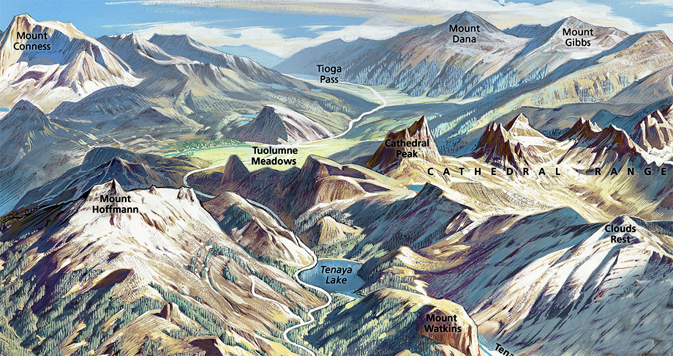
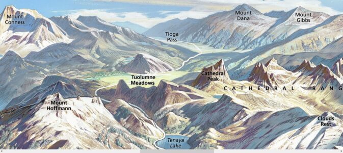
Yosemite Berann poster of Tuolumne Meadows, Tenaya Lake, Cathedral Peak, Clouds Rest, Tioga Pass, Mount Hoffmann, Mount Conness, Mount Dana and Mount Gibbs courtesy of NPS:
__________________________________________
Snow camp carpools and driving directions has driving directions from Silicon Valley to Yosemite Valley, including routes 140 and 120 (and few notes about 99/145/41). Info there could help you drive from Tuolumne and/or Crane Flat to Yosemite Valley.
Details advice about using the Yosemite valley free shuttle bus is at: https://marydonahue.org/yosemite-valley-free-shuttle-bus
__________________________________________
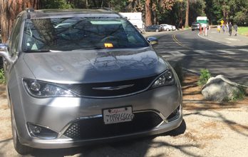
There is little parking in Yosemite valley or Tuolumne beyond your campsite, hotel area or day use parking. Park off the side of the road, not in a parking space, (as in the photo below, off road behind a large rock meant to deter anyone from parking there) and you can get a parking ticket with a $200 + fine (orange ticket under the windshield wiper) in this photo:
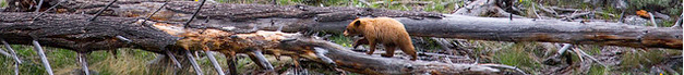
The Yosemite National Park rangers would like you to call them
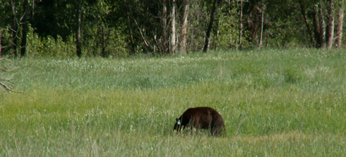
if you see a bear in Yosemite,
no matter where it is or what it is doing.
Since 2003 there has been a note in the Yosemite Guide: “REPORT ALL BEAR SIGHTINGS! To report bear sightings, improper food storage, trash problems, and other bear-related problems, leave a message for the Bear Management team at: 1 (209) 372-0322. Your call can be made anonymously.”
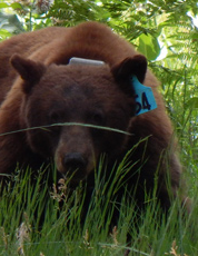
If you can, in all the excitement, try to notice if the bear has a tag (usually on the ear), the color of the tag and if possible, the number on it (the tag is large enough that with a telephoto lens you should be able to read the number).
From the Yosemite Daily Report newspaper:
“It is extremely important to remember to yell at bears that are in and around development, even if they are foraging on natural food. Though it is very tempting to get close for a picture, or just to watch these incredible animals, it is important not to give into this urge. Yelling at them if they are in residential areas or near people is critical to keep bears natural fear of humans. Giving bears plenty of space. When bears become too comfortable around people, they will often start causing damage to structures and vehicles, or will even become too bold around people, creating safety concerns.”
And the Yosemite Daily Report also said:
“Scare bears when you see them. . . in developed areas- Yell like you mean it!
Make as much noise as possible, try waving your arms, stomping your feet
or anything to make you look intimidating and to get the bear to run away.
We know it’s fun to see bears and it can feel mean to scare them,
but this is a simple way to truly help save a bear’s life.”
Yosemite driving distances
junction Big Oak Flat road and El Portal Road
– Junction Northside and southside drives .9 mile
-Junction Northside and southside drives – junction El Cap crossover 1.4 miles
(Southside drive) junction El Cap crossover – junction at Sentinel bridge 2.7 miles
junction at Sentinel bridge to junction at Curry Village (briefly named Half Dome Village) 1 mile
Yosemite Village – junction El Cap crossover 3.2 miles
Bridal Veil fall parking to far end of Wawona tunnel 1.6 miles
junction of Southside drive at Curry Village (briefly named Half Dome Village) to start of Happy Isles road .4 miles
start of Happy Isles road to Mirror Meadow bus stop 1.2 miles
Mirror Meadow bus stop to junction at start of Happy Isles road .4 miles
junction of Southside drive at Curry Village to main day use parking .8 miles
Yosemite Village to Tioga pass road 18 miles
Tioga pass road to Tioga pass entrance station 47 miles
Tioga pass entrance station to Lee Vining 13 miles
junction Tioga pass road to Big Oak Flat entrance station 9 miles
Big Oak Flat entrance station to Hetch Hetchy 18 miles
Yosemite Village to Chinquapin Junction 14 miles
Chinquapin Junction to Glacier Point 16 miles
Chinquapin Junction to south entrance station 17 miles
Yosemite Village to Arch Rock entrance station 11 miles
Arch Rock entrance station to Mariposa 34 miles
____________________________________________________________
Carpools are arranged among the students going on any Outdoor Club Trip, not by the club or the college. For info on how to get/give a ride go to Carpool FAQs
You might also want to read How to not collide with a deer, Safe driving in rain and fog, Prepare for winter driving, and/or wildlife jams</a
Road trip advice and etiquette has ideas for limiting boredom, getting along on a road trip and some packing and safety tips.
– – – – – – – – – – – – – – – – – – – – – – – – – – – – – – – – – – –
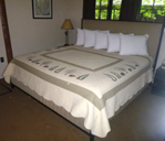
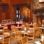
You have a number of lodging choices of where to stay overnight in Yosemite Valley in Yosemite National Park, including campsites or
wood-walled cabin without a bath; heated or unheated wood floored, canvas sided and roofed tent cabin; wood walled cabin with a bath
luxury or generic hotel rooms, suites with a bath
__________________________________________
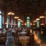
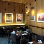
You can find basic to extravagant, (a few with a dress code),
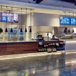
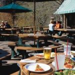
casual, fast (grab and go)
or with table-side service,
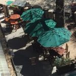
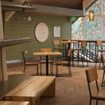
indoor and outdoor food service
at multiple locations in Yosemite Valley, as well as four grocery stores
all of which are served by the Yosemite valley free shuttle bus.