Here is a map of locations, walkways and restrooms in a display right at Mirror Lake in Yosemite valley:
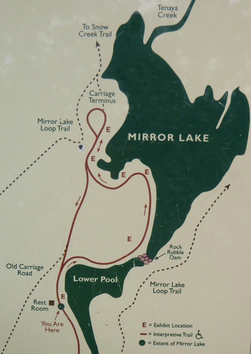
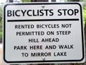
Please note that the “Rock Rubble Dam”, the pink dots between the two sections of Mirror lake, is a dangerous place to try to cross the lake whenever there is much water at all. Google maps 360 degree street view of Mirror Lake with the partially submerged “Rock Rubble Dam”
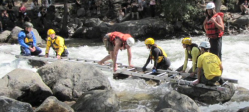
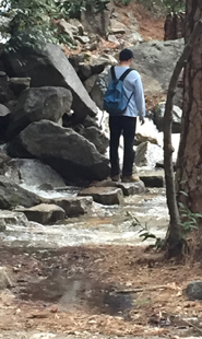
and see this video of near-tragedy when two young men tried to cross Tenaya Creek on rocks that looked to them like stepping stones, just above rapids, photo below of part of the rescue:
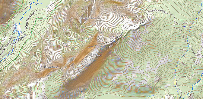
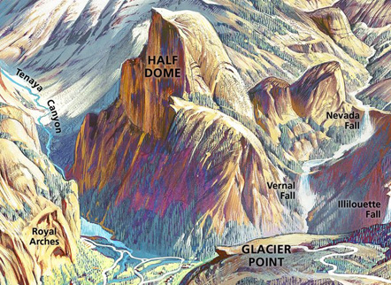
Here a topographical map showing Mirror Lake on the left and Half Dome in the center:
The NPS photo below was taken from Half Dome down to Mirror Lake. In the lower left you can see the road that is one of the routes to the lake:
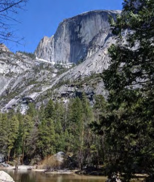
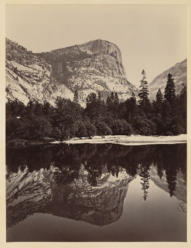
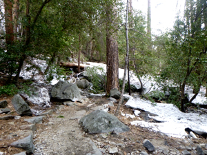
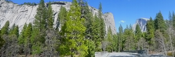
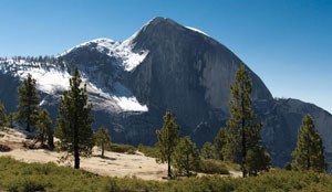
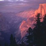
Half Dome rises right above the lower pool of Mirror Lake:
Mount Watkins is on the left in this photo, with the bottom edge of Half Dome showing on the right:

Both of the above photos were taken in May with lots of water in Mirror Lake. By the end of the summer it is much more dried up.
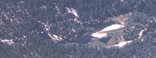
Photos below of Mirror lake in April (with water) and August (dried up in a dry year) are courtesy of the National Park Service.
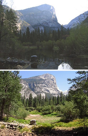
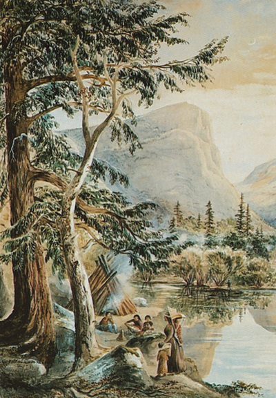
Exhibit caption for photo below: “Carleton Watkins, an early photographer of Yosemite, captured this pristine view of Mirror Lake while most of the country was engaged in the Civil War. One of the best landscape photographers of the 19th century, Watkins used the cumbersome, demanding technology of his era, which required large glass wet plate negatives, and produced some of the most stunning images of this extraordinary wilderness. His views are credited with inducing members of Congress to pass legislation in 1864 that required California to protect the area from development. Abraham Lincoln signed the bill and was also reported to have been very taken with the beauty of the images. Subsequent efforts by landscape designer Frederick Law Olmsted and naturalist John Muir resulted in Yosemite being proclaimed a national park in 1890.”
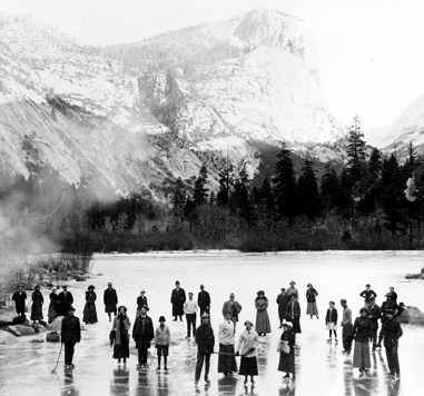
Here, photo courtesy of the Library of Congress, people ice skating on Mirror Lake in 1911.
(You should not expect the water to freeze well enough for safe ice skating.)
Here, Half Dome with Mirror Lake below it:
You can see a full sized copy of this drawing
Here, photo of a painting courtesy of the NPS. The Yosemite Park webpage said:
“Constance Gordon-Cumming: Indian Life at Mirror Lake, 1878
Lady Constance Frederica Gordon-Cumming, born in 1837, was a travel writer and landscape painter from a wealthy Scottish family. She taught herself how to paint, helped by prominent artists visiting her home. She traveled the world, often alone, to paint and write about her journeys. She arrived in Yosemite in 1878 after traveling from Tahiti to San Francisco. She intended to visit for three days, but ended up staying for three months, holding the first art exhibit in Yosemite Valley. Of her visit to Yosemite, Gordon-Cumming wrote, “I for one have wandered far enough over the wide world to know a unique glory when I am blessed by the sight of one . . .”
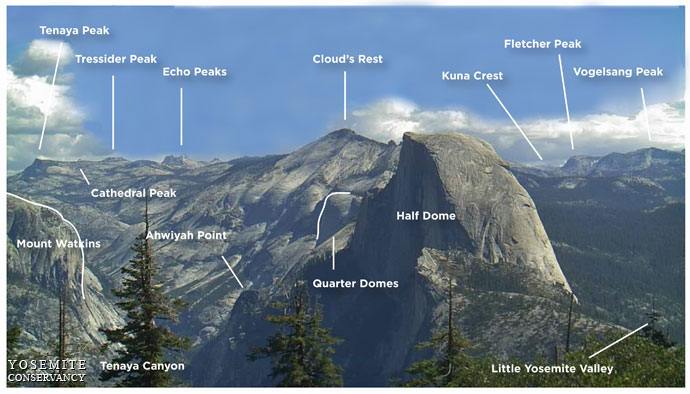
A different perspective of the depth of Tenaya Canyon, and the positions of Mount Watkins and Half Dome at Mirror Lake can been seen from the top of Sentinel Dome. From Sentinel Dome you can see Half Dome, Mount Watkins, Tressider Peak, Clouds Rest, Kuna Crest, Fletcher Peak, Vogelsang Peak, Mount Watkins, Cathedral peak, Ahwiyah Point, Quarter Domes, and Little Yosemite Valley and Tenaya Canyon and each of these is identified at a key to the view.
Dogs and bikes are prohibited on all unpaved trails in Yosemite (see also links to Yosemite rules and regulations )
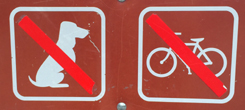
Two paved (former roads) routes to Mirror Lake are okay for dogs (on a maximum 6 foot leash) and bikes, strollers.
– – – – – – – – – – – – – – – – – – – – – – – – – – – – – – – – – – – – – – – – – – – – – – – – – – – – – – – – – –
There are five potential routes / trails / roads to get to Mirror Lake, four from Yosemite valley, and one much longer route from the high country.
– – – – – – – – – – – – – – – – – – – – – – – – – – – – – – – – – – – – – – – – – – – – – – – – – – – – – – – – – –
The Snow Creek trail is a 11.3 mile hike from Tenaya Lake or 8.2 miles from Highway 120.
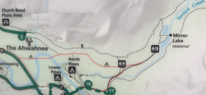
The map below shows the end of the multi-mile Snow Creek trail in pink at the top right, (and see descriptions below) two routes from the Ahwahnee hotel in gray, two routes that start at shuttle stop 17 in yellow and orange.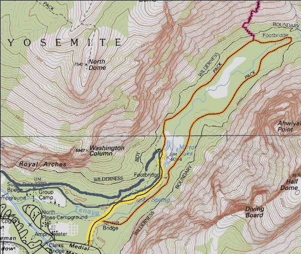
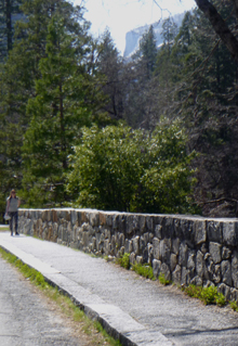
Two routes are from the Ahwahnee Hotel, (briefly named the Majestic Yosemite Hotel). On the unpaved hiking trail or the paved road route you may find fewer people than on other routes from Yosemite valley. Use the free shuttle bus to take you to stop 3.
The unpaved trail along the cliffs below the Royal Arches, (across the parking lot from the Ahwahnee hotel entrance, the top, black dotted line on the map below) is longer but can be much more pleasant and less crowded than the paved road from free shuttle bus stop 17, the usually recommended hike start. OR, if that trail is too wet or you are riding a bike, or have a dog, or have a stroller you can use the route of the dotted line just below that one.
Please note that some of the the shuttle bus stops on the NPS map below changed numbers, so I edited some stop numbers out. #3 Ahwahnee, and #17 Mirror Lake (as well as #18 Lower pines campground) are the same. (See free shuttle bus for all the stops.)
A paved road for bikes starts (gravel at first, then later paved) to the right of the north-east end of the main Ahwahnee hotel guest parking lot.
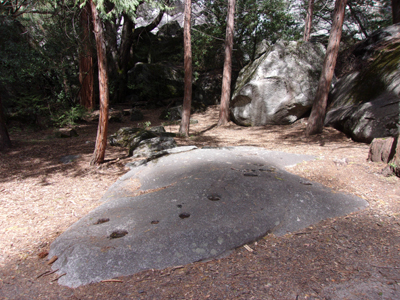
At the start of the cliffside hiking trail, also right next to the parking lot, on the left hand side of the trail, you might be able to spot a rock where Yosemite indians ground acorns and left behind deep holes in the rock. (You could call it the original Ahwahnee kitchen.)
![]()
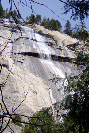
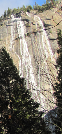
This walk / hike takes you under the Royal Arches, and the Royal Arch Cascade coming down when there is sufficient water to flow, as seen from the hotel:
and as seen out on the hotel grounds in the cottages area:
I am leaving this description below of the cliffside trail from the Ahwahnee to Mirror lake, but please note that the start of it was closed for awhile and could be closed again.
The maps below are from:
Public Safety Closure – Rockfall Hazard West of Royal Arches
August 30, 2023 (until April 2026)
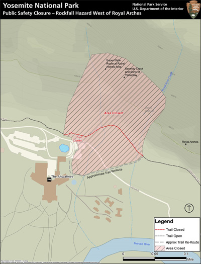
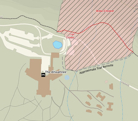
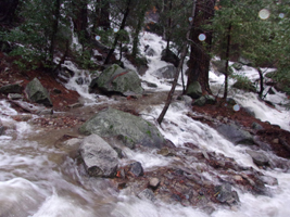
At the start of the cliffside trail, (see where the words “Trail Closed” in red type are in the map above) in some months, you can see and feel mist from the Royal Arch Cascades or may be walking in water.
(In heavy rain – two photos below from February 2017 – the white is not snow, it is rushing water – this section of trail can become an unsafe creek/river!)
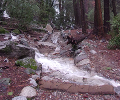
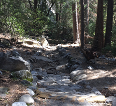
Compare the photo above to April 2017:
Or you could find it blocked by a huge snow bank (April 2023 after heavy snow storms.)
If you start up the trail and decide it is too wet for you,
you can turn around, then turn left and walk the dirt/paved road past the main parking lot, (this route is okay for bikes, strollers and dogs on a “not more than six feet long” leash, see Yosemite Pets rules)
through some storage and on to where it dead ends at a “T” intersection with a paved road/path. (Looking again at the map of the closure, the white line starting just below the words “Trail Closed” with “(unpaved)” on it at the right hand lower corner is this dirt road:
Where it dead ends at a “T” intersection with a paved road/path, you then turn left, perhaps after walking out on Sugarpine bridge to take a look at the river.
In the photo below, the Ahwahnee hotel is in the upper left, the Ahwahnee Bridge crosses the Merced River near the center and Sugarpine Bridge is to the right.
This section was originally a road and may have park service vehicles (but park visitors can not drive on it).
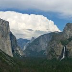
At the west end of Sugarpine Bridge you can take a panorama photo of Royal Arch Cascades (coming down the cliff on the left in the photo below) and Half Dome:
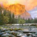
And looking to the west while on Sugarpine Bridge, you can see the top section of El Capitan, in the upper center of this photo:
This path will take you past backpacker’s walk-in campground
and on to join the road from shuttle stop #17 (which is described below).
Two more routes are from the “official” Mirror Lake trailhead beginning at at free shuttle bus stop #17, a walk up a former road (which is okay for vehicles with handicapped permits and may have park service vehicles as well).
And here is a NPS photo/map of the trail to Mirror Lake as a loop from shuttle stop #17, note the Ahwahnee hotel (labeled as the Majestic Yosemite Hotel) in the left hand side of the map:
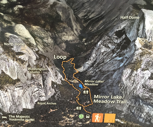
The left hand side of the orange dotted line is the road from shuttle stop #17, the right hand side is a unpaved trail that comes off the road. (The paved former road is okay for dogs (on a maximum 6 foot leash) and bikes. The trail that goes off to the side is not okay for dogs or bikes, not even for people skilled at riding their mountain bike.) The NPS notes: “You can bicycle the first mile of the trail to the end of the paved service road. From there, you can either turn around or park your bike and begin your hike.”
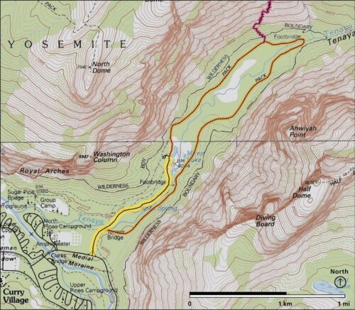
Here, an NPS map of the same loop above, with the road in yellow, the loop in orange and in pink, the end of the Snow Creek trail where it joins the Mirror Lake Loop:
Most of the way up the road, it becomes steeper and rental bikes are not allowed past that point.
And another Mirror Lake view, scroll up to see Half Dome
If you each take a photo of all the hikers in your group on your cell phone just before you start the hike, this can be used to document what each person was wearing, maybe quite helpful if someone gets lost.
and see more: Hiking advice.
Go beyond Mirror Lake on the Snow Creek trail for this Half Dome view:
The Snow Creek Falls trail from Mirror Lake
is the steepest climb out of the Valley, with these potential destinations:
Snow Creek Fall (top)……………………………..3.7 miles 6.0 Km
North Dome………………………………………… 9.0 miles 14.5 Km
Yosemite Falls (top)………………………………..14.0 miles 22.5 Km
El Capitan…………………………………………… 18.1 miles 29.1 Km
Old Big Oak Flat Road (Foresta)………………… 22.9 miles 36.8 Km
May Lake……………………………………………. 11.2 miles 18.0 Km
Tenaya Lake…………………………………………11.3 miles 18.1 Km
Tuolumne Meadows………………………………..20.0 miles 32.1 Km
——————————————————————-
We read in:
https://www.yosemite.ca.us/library/yosemite_resources/yosemite_resources.pdf
“With completion of the Wawona Road, interested parties began applying pressure to make the high country of the Tuolumne River more accessible for winter sports by constructing a tunnel road up through Tenaya Canyon. Herbert C. Hoover, on vacation in Yosemite before becoming President, had ridden horseback from the High Sierra camp at Tenaya Lake down the Snow Creek switchbacks into Yosemite Valley. Impressed with the scenery, he had suggested installing automatic elevators working by electrical power, possibly developed from waterwheels, that would take autos up and down alongside Snow Creek Falls. Hoover thought it would prove a great tourist attraction!”
![]()
Where were they when they got that great picture in Yosemite?
Where can I take a photo that looks like the one on a Yosemite postcard I just bought?
Places to take photos of Half Dome, Bridalveil Fall, El Capitan, Yosemite Falls and Staircase Falls.
![]()
Selfies can be great, OR dangerous. The use of cell phones for photography (with or without a selfie stick) has made preventable injury or even death by selfie common. They were only taking a selfie
Using a drone is illegal in Yosemite National park, including for photography. See an index of rules and regulations webpages.
Yosemite trail conditions info is at: http://www.nps.gov/yose/planyourvisit/wildcond.htm
Parking and traffic jams in Yosemite valley tips and tricks
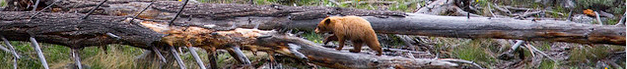
The Yosemite National Park rangers would like you to call them
if you see a bear in Yosemite,
no matter where it is or what it is doing.
Since 2003 there has been a note in the Yosemite Guide: “REPORT ALL BEAR SIGHTINGS! To report bear sightings, improper food storage, trash problems, and other bear-related problems, leave a message for the Bear Management team at: 1 (209) 372-0322. Your call can be made anonymously.”
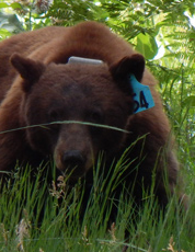
If you can, in all the excitement, try to notice if the bear has a tag (usually on the ear), the color of the tag and if possible, the number on it (the tag is large enough that with a telephoto lens you should be able to read the number).
The NPS notes: “Tagged, or radio collared, bears do not mean the bear is a “bad” bear. Tagging bears is done for better monitoring, and the ear tag color is completely random, used to help quickly identify a bear.”
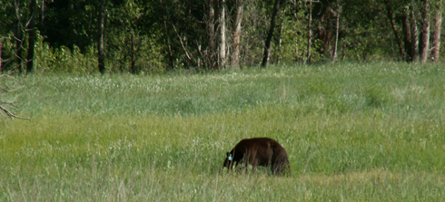
From the Yosemite Daily Report newspaper:
“It is extremely important to remember to yell at bears that are in and around development, even if they are foraging on natural food. Though it is very tempting to get close for a picture, or just to watch these incredible animals, it is important not to give into this urge. Yelling at them if they are in residential areas or near people is critical to keep bears natural fear of humans. Giving bears plenty of space. When bears become too comfortable around people, they will often start causing damage to structures and vehicles, or will even become too bold around people, creating safety concerns.”
And the Yosemite Daily Report also said:
“Scare bears when you see them. . . in developed areas- Yell like you mean it!
Make as much noise as possible, try waving your arms, stomping your feet
or anything to make you look intimidating and to get the bear to run away.
We know it’s fun to see bears and it can feel mean to scare them,
but this is a simple way to truly help save a bear’s life.”