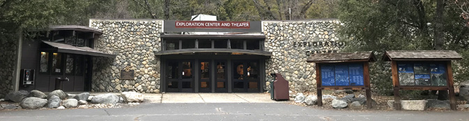
At the Yosemite Exploration Center (previously named the Yosemite Valley Visitor Center)
at free shuttle bus stop #5,
There are displays, maps, nature info and
there is a bookstore with maps, books, postcards, posters, calendars, clothes (with discounts for Yosemite Conservancy donors).
AND at the back of the Valley Day Use parking lot at shuttle bus stop #1 there have been more displays showing trails, see below.
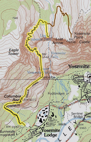
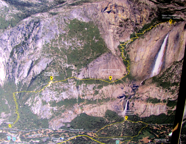
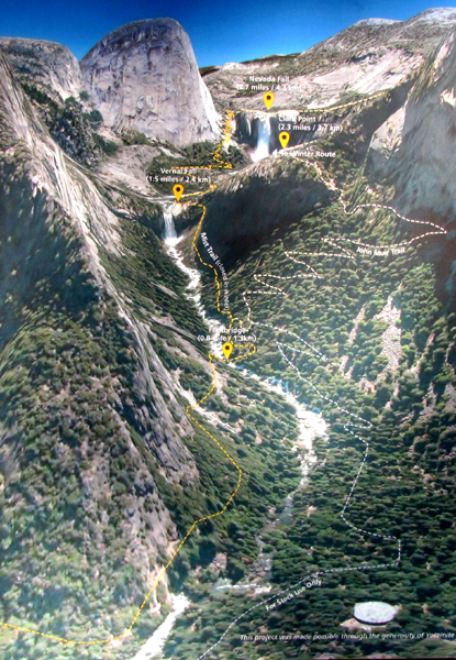
Even when the Exploration Center is closed (early morning or overnight or during government shutdowns) you can find a lot of info about trails on the two displays outside the Exploration Center, to the right in the photo above. The giant color photos shown below include the Four Mile trail to Glacier Point / Union Point, Mirror Lake Trail, Vernal and Nevada Falls and Upper and Lower Yosemite Falls / Columbia Rock. You could take a photo of the color trail map on your smart-enough-phone to reference as you hike, or please do feel free to download these photos I took of the display(s) (and another from the NPS of a topographical map):
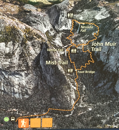
Vernal Fall Mist Trail and beyond to Nevada Falls
Four Mile trail from Yosemite Valley to Glacier Point (closed in winter, often opens in March or April) :
![]()
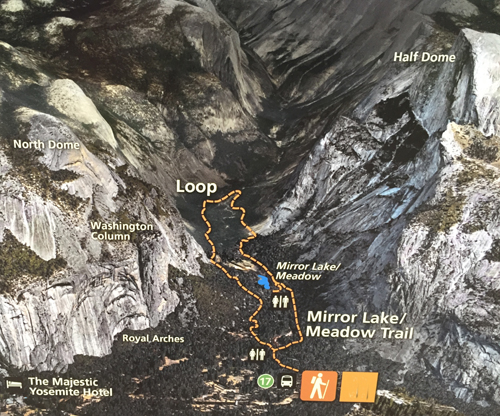
Mirror Lake trail:
![]()
![]()
At the back of the parking lot at Yosemite shuttle bus stop #1, along a path to the Village store area, there have been displays of color photo trail maps
including this of the two ways to go to Vernal and/or Nevada Fall, (most people go up the Mist trail and down the John Muir trail and in winter only some parts of the trail may be open, see Mist Trail info.)
This shows the loop trail to Mirror Lake from shuttle stop #17 (but also see an alternative trail from the Ahwahnee (which had been temporarily named the Magestic Yosemite Hotel) about half way down the webpage at this map.
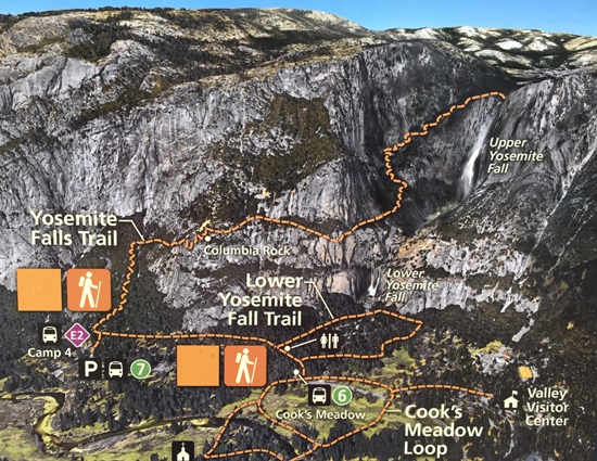
This shows the trails to lower Yosemite Falls from shuttle stop #6, the trail to Columbia Rock and on to the top of Upper Yosemite Fall, and the trail thru Cook’s Meadow.
If you take the lower section of the figure-8-ish Cook’s Meadow loop, you will cross a bridge with a display about the many times Yosemite Valley has flooded so badly it has become a lake.
Here you can compare the elevation gain and length of various strenuous hikes up from / down to Yosemite Valley:
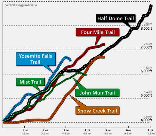
Note that the chart says “vertical exaggeration five times.”
![]()
The Yosemite Guide newspaper, which you will be offered a copy of as you pay at an entrance station to enter the park, (or you can read, download or print in advance) has hours of operation for the Exploration Center, visitor centers, museums, tours, stores, food service, post office, laundromat, showers, auto service, gas stations, and a calendar of park activities including Ranger walks. It also includes the most current map of the free Yosemite valley shuttle bus route.
Search for topographical maps at the USGS website:
https://ngmdb.usgs.gov/topoview/viewer/#4/39.98/-100.06
And / or you can download an App with “information about park services and programs, as well as an interactive map designed to help visitors locate iconic features, scenic spots, trailheads and amenities.”
Yosemite trail conditions info is at: http://www.nps.gov/yose/planyourvisit/wildcond.htm
– – – – – – – – – – – – – – – – – – – – – – – – – – – – – – – – – – – – – – – – – – – – – – – – – – – – – – – – – –
Cell phone service is NOT available in all parts of Yosemite.
It is usually okay in the vicinity of the Exploration Center.
Many years we got 4 bars for Verizon and 3 bars for AT&T near the Exploration Center, versus 2 bars for each at the Ahwahnee and 2 bars Verizon, 1 bar AT&T in Upper Pines campground, at the Yosemite Valley Lodge, Curry Village and some other locations in East Yosemite Valley.
The park service said: “Cell phone coverage in Yosemite is spotty . . . Cell service is often impacted during daily peak visitation by the large number of people trying to access limited service; if you have four bars of service, but you can’t get a signal, this is why . . . cell coverage depends on your phone, the cloud cover and other seemingly mysterious factors and is not always reliable. ”
Outside of Yosemite valley, at the Tuolumne Grove, Olmstead Point and Badger Pass have been 1 bar Verizon, zero bars AT&T. Glacier Point and the top of Half Dome often have 3 bars Verizon, 2 bars AT&T.)
Parking and traffic jams in Yosemite valley tips and tricks
Details about 24 hour towing within the park, propane service, emergency repairs, how to use your Auto Association card to get the help of the people at the small Yosemite Village garage, electric vehicle (EV) charging stations and more are at Yosemite garage, car repairs and towing.
Where did they get those pictures of Half Dome, Yosemite Falls and Bridalveil Falls?
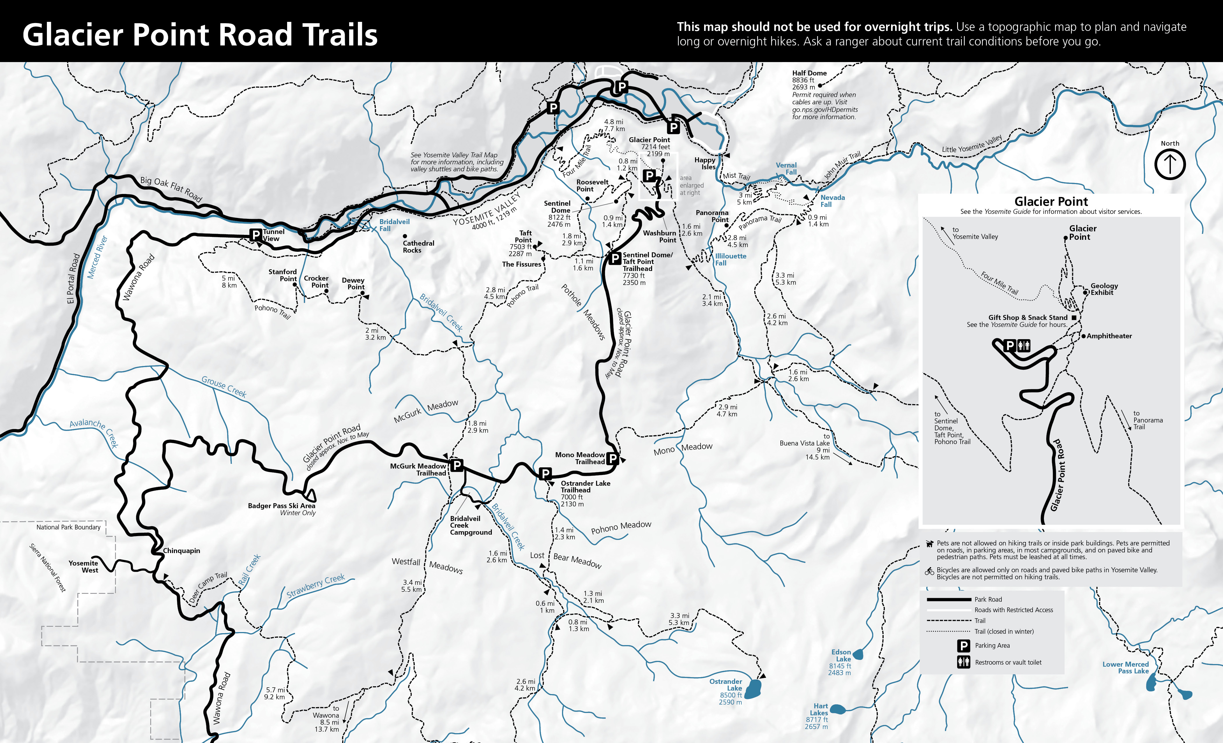
A Glacier Point hiking map https://www.nps.gov/yose/planyourvisit/images/TrailMaps_GP_2024_V1.jpg includes trails to / around (easy) Glacier Point, Mc Gurk Meadow, (moderate) Dewey Point, Taft Pint and the fissures, Sentinel Point, Taft Point / Sentinel Dome loop, (strenuous) Four Mile Trail, Panorama Trail, Mt Starr King View, Ostrander Lake and Pohono trails.
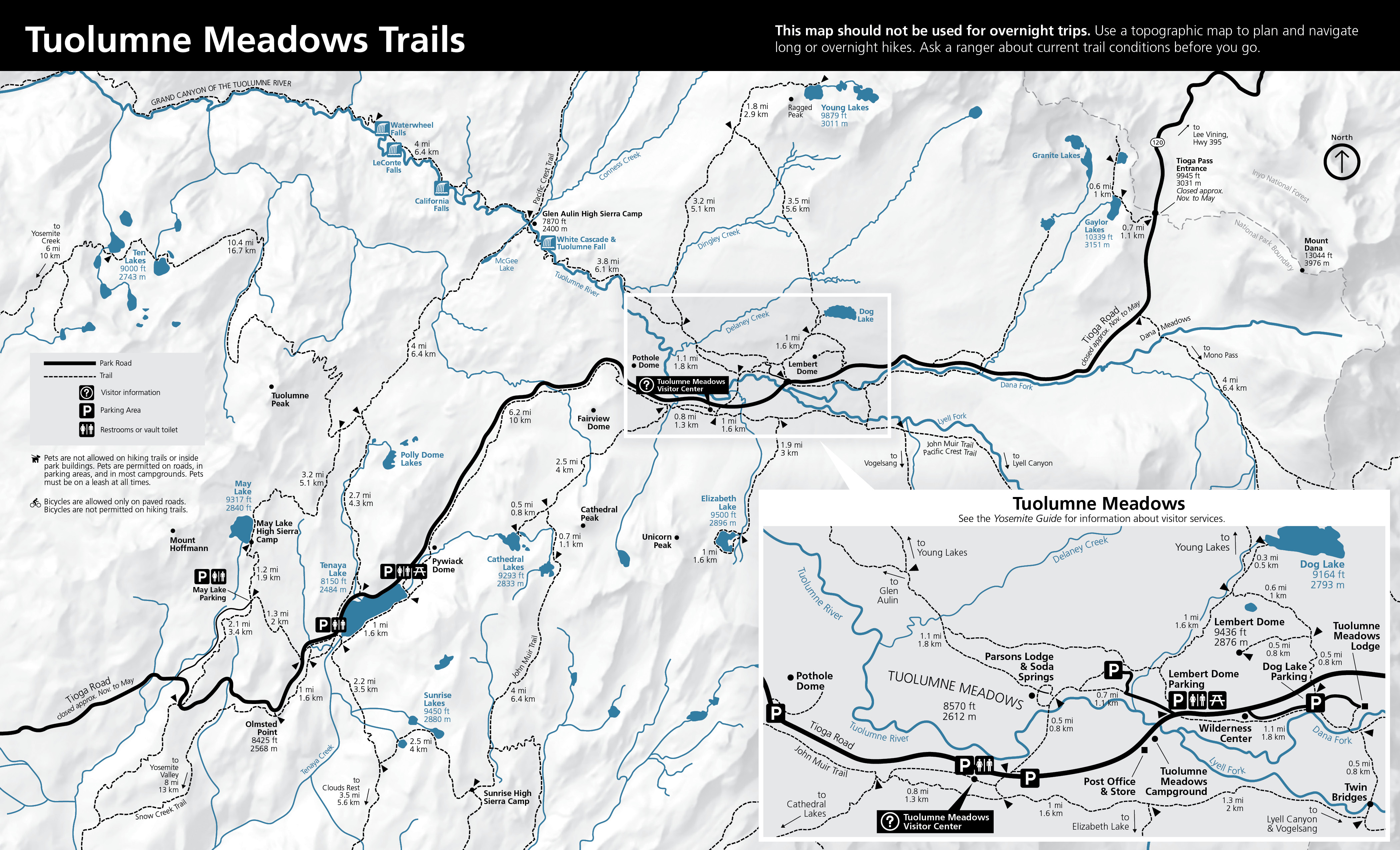
A Tuolumne Meadows hiking map https://www.nps.gov/yose/planyourvisit/images/TrailMaps_TM_2024_V1.jpg has trails to / around (easy, mostly flat) Soda Springs/Parsons Memorial Lodge, Lyell Canyon via the John Muir Trail, (moderately Strenuous, moderate elevation gain) Dog Lake or Lembert Dome, Elizabeth Lake, Cathedral Lakes, Glen Aulin, Mono Pass, Gaylor Lakes, and (strenuous, long with elevation gain) Vogelsang Area.
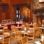
Yosemite valley overnight accommodations (cabins, tent cabins, hotel rooms, campgrounds, with maps of most areas),

You can find basic to extravagant, (a few with a dress code),
casual, fast (grab and go)
or with table-side service,
indoor and outdoor food service
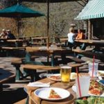
at multiple locations in Yosemite Valley, as well as four grocery stores


all of which are served by the Yosemite valley free shuttle bus.
Selfies can be great, OR dangerous. The use of cell phones for photography (with or without a selfie stick) has made preventable injury or even death by selfie common. They were only taking a selfie
![]()
Using a drone is illegal in Yosemite National park, including for photography. See an index to over a dozen park webpages with park laws, rules, regulations, policies and prohibitions about pets, bikes, permits, campground regulations, food storage, smoking, speed limits . . . and much more.
__________________________________________
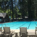
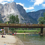
swimming in Yosemite including thunderstorms, bacteria in the water, safety issues, favorite beaches, swimming pools with lifeguards, places you should not swim.
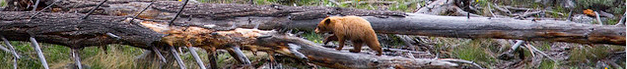
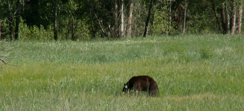
The Yosemite National Park rangers would like you to call them
if you see a bear in Yosemite,
no matter where it is or what it is doing.
Since 2003 there has been a note in the Yosemite Guide: “REPORT ALL BEAR SIGHTINGS! To report bear sightings, improper food storage, trash problems, and other bear-related problems, leave a message for the Bear Management team at: 1 (209) 372-0322. Your call can be made anonymously.”
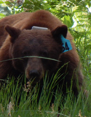
If you can, in all the excitement, try to notice if the bear has a tag (usually on the ear), the color of the tag and if possible, the number on it (the tag is large enough that with a telephoto lens you should be able to read the number).
The NPS notes: “Tagged, or radio collared, bears do not mean the bear is a “bad” bear. Tagging bears is done for better monitoring, and the ear tag color is completely random, used to help quickly identify a bear.”
From the Yosemite Daily Report newspaper:
“It is extremely important to remember to yell at bears that are in and around development, even if they are foraging on natural food. Though it is very tempting to get close for a picture, or just to watch these incredible animals, it is important not to give into this urge. Yelling at them if they are in residential areas or near people is critical to keep bears natural fear of humans. Giving bears plenty of space. When bears become too comfortable around people, they will often start causing damage to structures and vehicles, or will even become too bold around people, creating safety concerns.”
And the Yosemite Daily Report also said:
“Scare bears when you see them. . . in developed areas- Yell like you mean it!
Make as much noise as possible, try waving your arms, stomping your feet
or anything to make you look intimidating and to get the bear to run away.
We know it’s fun to see bears and it can feel mean to scare them,
but this is a simple way to truly help save a bear’s life.”