The Grand Teton park newspaper prints this drawing of most of the mountain peaks of the Teton Range, with their names and summit (top, highest) elevations:
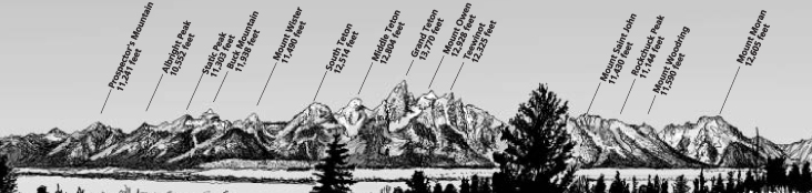
See also below, photo maps of the skyline and more lists of peak names / summit (top, highest) elevations plus a link to profile drawings of the Teton Range with the names of peaks seen from three views along the highways, to help you identify each peak you see.
The Grand Teton National Park newspaper said this about the origins of the names of the peaks:
“Static Peak In the Teton Range north of Death Canyon. Named because it is often hit by lightning.
Buck Mountain Named for George A. Buck, recorder for T.M. Bannon’s 1898 mapping party. Bannon gave the name “Buck Station” to the triangulation station he and George Buck established on the summit in 1898.
Grand Teton Highest mountain in the Teton Range. Named by French trappers. Upon viewing the Teton Range from the west, the trappers dubbed the South, Middle, and Grand, Les Trois Tetons, meaning ”the three breasts.” Wilson Price Hunt called them ”Pilot Knobs” in 1811 because he had used them for orientation while crossing Union Pass. In his Journal of a Trapper, Osborne Russel said the Shoshone Indians call them the hoary headed Fathers.
Mount Owen Northeast of the Grand Teton. Named for W.O. Owen, who climbed the Grand Teton in 1898 with Bishop Spalding, John Shive, and Frank Petersen.
Teewinot Towers above Cascade Canyon and Jenny Lake. Its name comes from the Shoshone word meaning “many pinnacles.” Teewinot probably once applied to the entire Teton Range, rather than just this one peak. Fritiof Fryxell and Phil Smith named the peak when they successfully completed the first ascent of the mountain in 1929.
Mount Saint John Between Cascade and Paintbrush canyons. A series of peaks of nearly equal height. Named for Orestes St. John, geologist of Hayden’s 1877 survey, whose monographs of the Teton and Wind River ranges are now classics.
Mount Moran Most prominent peak in the northern end of the Teton Range. Named by Ferdinand V. Hayden for the landscape artist Thomas Moran, who traveled with the 1872 Hayden expedition into Yellowstone and into Pierre’s Hole on the western side of the Teton Range. He produced many sketches and watercolors from these travels.
From the book Origins by Hayden and Nielsen.”
– – – – – – – – – – – – – – – – – – – – – – – — – – – – – – – – – – – – – – – – – –
When you are first trying to figure out which peak you are seeing, it can help to remember that
the summit (top) of Grand Teton is pointed, tilting slightly towards the north.
The summit of Mount Moran is flatter.
![]()
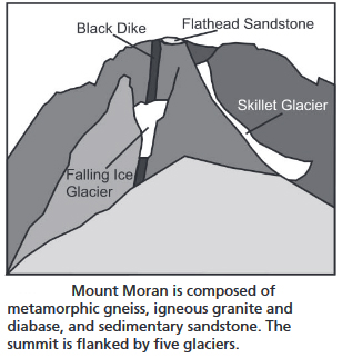
The black dike shown above is “previously molten material was injected into cracks of the Archean rocks that form the mountain. The dike is about 46 m (150 ft) wide and cross-cuts the Teton Range for about 16 km (10 mi),” according to the NPS in: https://www.nps.gov/articles/nps-geodiversity-atlas-grand-teton-national-park-wyoming.htm .
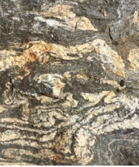
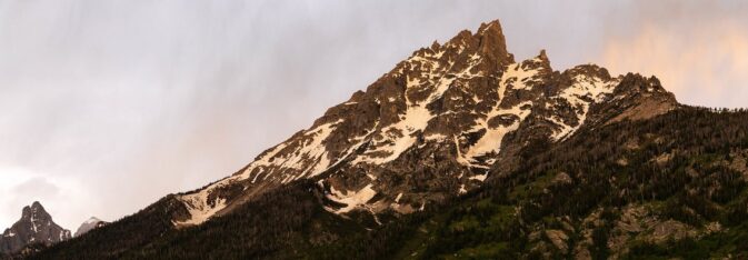
Here, 2.7 billion year old metamorphic gneiss (pronounced “nice,”) with stripes that sparkle, that makes up part of Mount Moran:
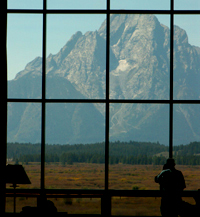
The floor to ceiling windows (two story, 60 feet tall) of Jackson Lake Lodge have Teton range views, through the section of window pictured below, the peak is Mount Moran.
– – – – – – – – – – – – – – – – – – – – – – – – – – – – – – – – – – –
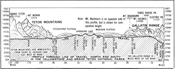
Below a drawing of heights of peaks in Grand Teton and Yellowtone National parks (Gallatin Range) for comparison, including Grand Teton, Mt Moran, Mt Washburn, Mt Holmes, Three Rivers Peak, Electric Peak from the book Grand Teton National Park by the United States Dept. of the Interior:
– – – – – – – – – – – – – – – – – – – – – – – – – – – – – – – – – – –
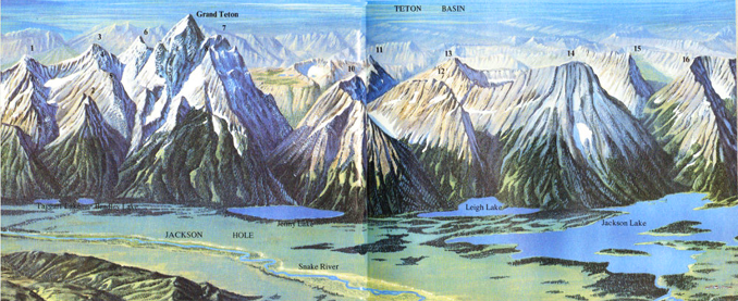
In the NPS book: Grand Teton
A Guide to Grand Teton National Park, Wyoming
from left to right in the painting below
1) Mount Wister, 2) Shadow Peak, 3) South Teton, 4) Cloudveil Dome, 5) Nez Perce Peak,
6) Middle Teton, 7) Mount Owen, 8) Teewinot Mountain, 9) Rockchuck Peak, 10) Mount St. John, 11) The Jaw, 12) Mount Woodring, 13) Maidenform Peak, 14) Mount Moran, 15) Window Peak,
16) Bivouac Peak
– – – – – – – – – – – – – – – – – – – – – – – – – – – – – – – – – – –
Middle Teton with a black dike, as seen from Garnet Canyon:

– – – – – – – – – – – – – – – – – – – – – – – – – – – – – – – – – – –
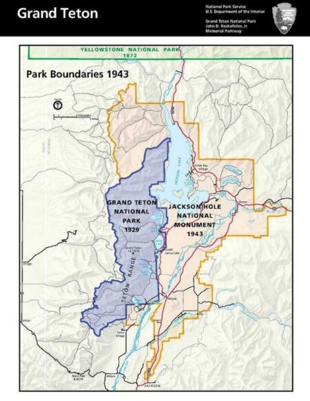
When Grand Teton National Park was established in 1929 it included the Teton mountain range and most of the lakes at the base of the range. In 1950 the present boundaries were created by an act of Congress. There are still private parcels within the park, but some have been given to the park or purchased by the park.
On the NPS map below you can find Grand Teton National park boundaries in 1929, and 1943 (Jackson Hole National Monument). 1950 had the addition of the John D. Rockefeller Jr. Memorial parkway between Grant Teton and Yellowstone.
– – – – – – – – – – – – – – – – – – – – – – – – – – – – – – – – – – –
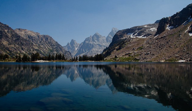
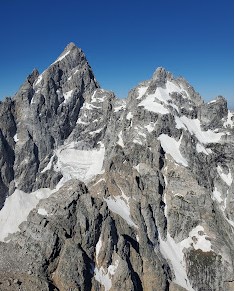
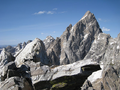
The Cathedral Group is Grand Teton, Mt. Owen, Teewinot and from some viewpoints, some say it includes Mount St. John.
As seen from the North Fork of the Cascade Canyon Trail, (right to left below) Grand Teton, Mount Owen, and Teewinot Mountain
The Cathedral Group as seen from Lake Solitude up above Cascade Canyon (right to left below) Grand Teton, Mount Owen, and Teewinot Mountain:
Teewinot, with the top of the Grand Teton just showing on the left hand side of the photo:
Grand Teton on the left and Mount Owen as seen from Teewinot:
Teewinot from the Apex Trail:
– – – – – – – – – – – – – – – – – – – – – – – – – – – – – – – – – – –
At the Grand Teton Climbing Rangers webpages we read:
“Mount Owen is one of the greatest of the Teton peaks in height, beauty, and climbing interest. Named for William Owen, pioneer Wyoming surveyor and organizer of the 1898 ascent of the Grand Teton, it was one of the last of the high peaks to be ascended, resisting several early attempts. Not until 1930 did the very strong first-ascent party of Underhill, Fryxell, Smith, and Henderson solve the problem of the summit knob. Even today there is no easy way to the summit and every route requires mountaineering skill, demanding a consistent level of attention. Many parties tackling this challenging peak underestimate the length of an Owen endeavor and spend an unexpected second night in the mountains. Plan accordingly!”
“Teewinot Mountain The name for this salient peak was bestowed by the first-ascent party. Tee-Win-At, as it was originally spelled, is, according to the first-ascent party, a Shoshone word meaning “pinnacles.” This peak is certainly one of the most important of the Teton peaks both in placement and in size. From the Jenny Lake Visitor Center this mountain is the highest visible, and some visitors mistake it for the Grand Teton. Although a long climb of 5,600 feet, Teewinot is one of the more popular peaks.”
“Disappointment Peak The members of the first-ascent party were unfamiliar with the topography of the Grand Teton area and had thought that they might be able to reach the summit of the Grand Teton by climbing directly from Amphitheater Lake. Upon reaching Disappointment Peak and seeing the great gap between them and the Grand Teton, they attempted, but failed, to traverse farther toward their objective; Phil Smith and Walter Harvey named the peak on their return.
Disappointment Peak is viewed as a relatively easy, readily accessible peak with a spectacular view, however, like many “scrambles” in the Tetons accidents have occurred on the “standard” SE Ridge Route. In early season steep snow must be negotiated in the couloir above the chockstones and an ice axe and possibly crampons are required equipment.”
“Symmetry Spire, rising immediately above Jenny Lake, appears insignificant when the entire range is viewed from a distance, but this small peak has played a major role in the development and history of Teton mountaineering. The routes pioneered by Durrance and Jensen became early classics of the range and served as standard objectives for enterprising climbers who wished to apply their skill to Teton rock. With the advent of newer, more difficult rock climbs such as those in Death, Garnet, and Cascade Canyons, the Symmetry climbs have seen reduced activity, but they remain fine climbs and even today can be recommended. Although it is primarily a rock climber’s peak, ice axes must usually be taken because of the steep snow in Symmetry Couloir in early season and in the Southwest Couloir even in mid-season.”
– – – – – – – – – – – – – – – – – – – – – – – – – – – – – – – – – – –
At the Grand Teton Climbing Rangers webpages we read:
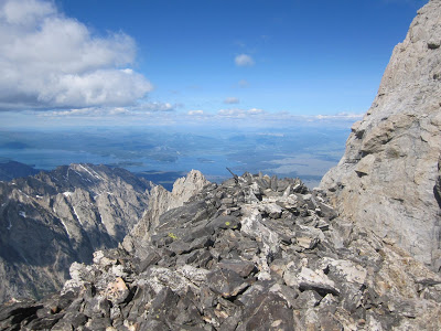
“The Enclosure (13,280′) The western spur of the Grand Teton, the second highest point in the Teton Range, holds a curious man-made structure within a few feet of its summit. Discovered in the course of the controversial attempt to climb the Grand Teton on July 29,1872, it was originally described as an “enclosure” by Nathaniel P. Langford in his now-famous 1873 article in Scribner’s Monthly. This enclosure consists of an elliptical arrangement of flat rocks placed on edge, 7 by 9 feet across and 3 feet high. This “enclosure” was most likely built by Native Americans at a time ancient or recent (19th century), perhaps as a part of a “visionquest” or other ceremony. Today, the Enclosure not only offers the non-technical climber a summit second only to the Grand Teton, but dozens of multi-pitch alpine and mixed routes for the seasoned alpinist.”
http://tetonclimbingpass.blogspot.com/
– – – – – – – – – – – – – – – – – – – – – – – – – – – – – – – – – – –
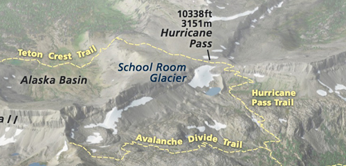
Grand Teton National Park has ten named glaciers or some texts mention 14 glaciers.
NPS: School Room Glacier and Hurricane Pass and relation to the Teton Pass trail and Hurricane Pass trail.
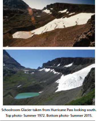
Schoolroom Glacier melting, 1972 to 2015 comparison:
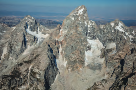
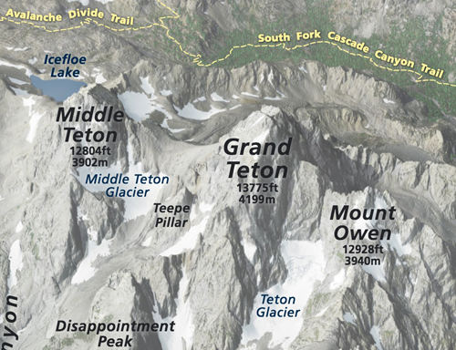
Part of the Teton Range showing three glaciers from left to right
— Middle Teton, Teepe, and Teton Glaciers:
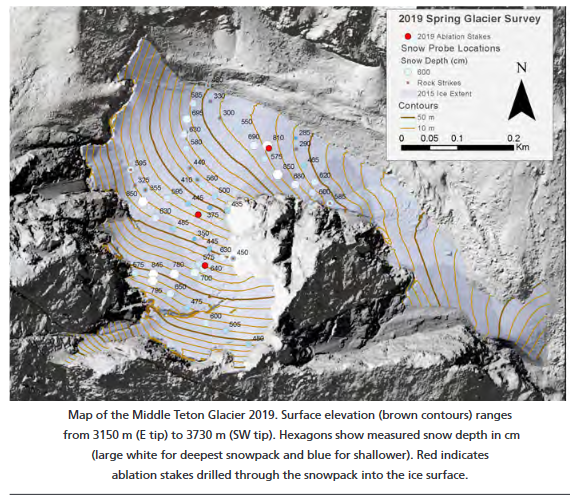
Map of Middle Teton Glacier from the NPS:
NPS photo map of Middle Teton Glacier and Teton Glacier in relation to the Middle Teton, Grand Teton and Mount Owen:
In https://www.nps.gov/grte/learn/nature/glaciers.htm, we read:
“The Middle Teton glacier sits on the northeast flank of the Middle Teton, and is visible along the route to the Lower Saddle. Old snow from the previous winter appears white near the top and central parts of the glacier in early August; exposed ice appears gray. Snow lasting through the summer is known as firn. Firn lasting for several years becomes glacial ice.”
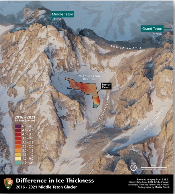
Below, a map showing middle teton glacier ice thickness loss between 2016 and 2021 from the park service website
https://www.nps.gov/grte/learn/nature/mapping-glaciers.htm
And see current glacier monitoring: https://www.nps.gov/grte/learn/nature/glaciermonitoring.htm
Middle Teton Glacier:
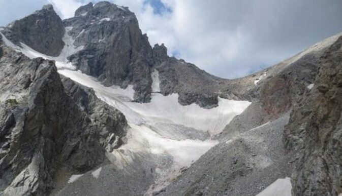
and another view of Middle Teton Glacier as seen from the Lower Saddle:

An NPS book notes that “Lower Saddle (11,600+ ft.) Located between the Grand and Middle Tetons, the Lower Saddle is often the scene of ferocious winds that prevail from the west.”
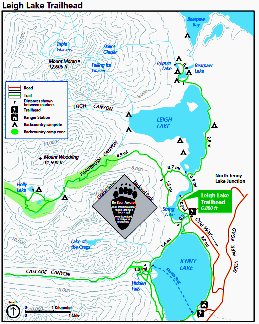
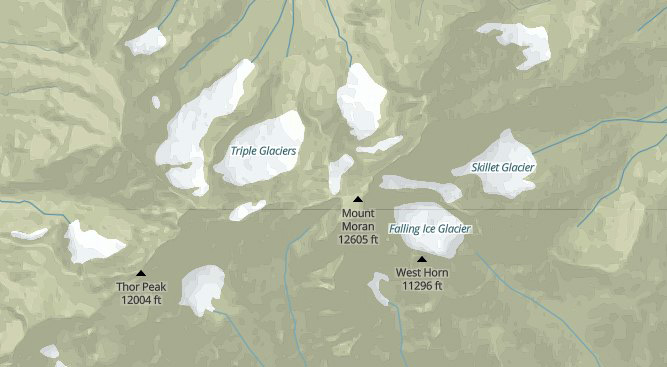
Triple Glaciers, Skillet Glacier and Falling Ice Glacier on Mount Moran
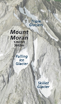
You can find the location of Triple Glaciers, Skillet Glacier and Falling Ice Glacier on Mount Moran and see where water melt from Falling Ice Glacier flows into Leigh Lake and water from Skillet Glacier flows into Trapper Lake on this topo map:
Grand Teton has this chart of sizes of glaciers, as they have shrunk between 1967 and 2022:
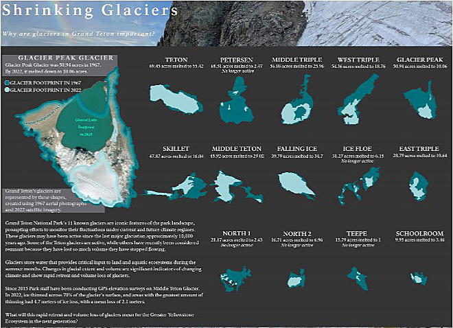
a larger, clearer copy can be seen at the 2023:
https://www.nps.gov/grte/learn/nature/vital-signs.htm
– – – – – – – – – – – – – – – – – – – – – – – – – – – – – – – – – – –
(Please note that there are peaks named the Three Sisters
in Canmore, Alberta, Canada and in Oregon,
but not in Grand Teton National Park.)
———————————————-
Signal Mountain, is not actually in the Teton range, but is a worthy drive for great views of the range.
– – – – – – – – – – – – – – – – – – – – – – – – – – – – – – – – – – –
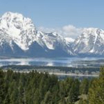
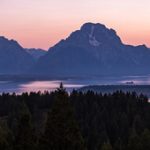
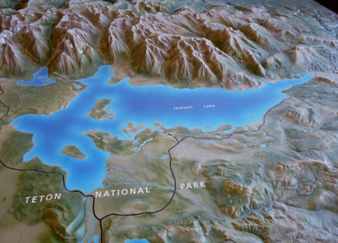
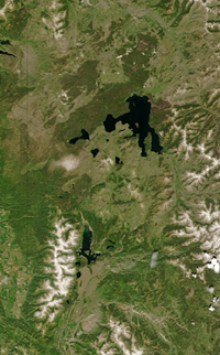
Below a NASA landstat photo of the range and lakes below it:
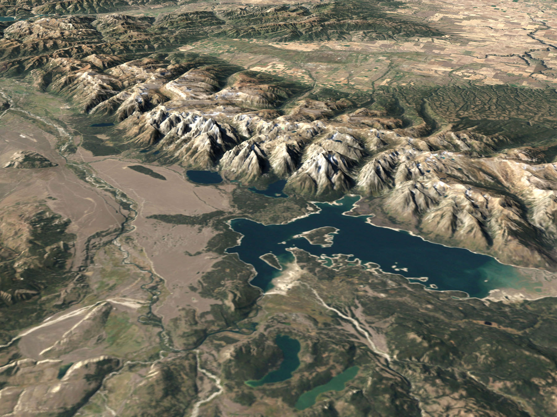
Compare it to a photo of a visitor center raised relief map. In both, Jackson lake is the biggest one, with Leigh Lake and Jenny Lake to the upper left of it. At the bottom are Two Ocean and Emma Matilda lakes.
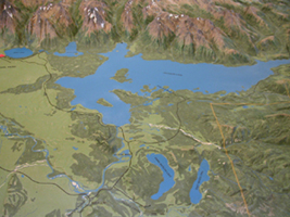
Here, a closeup of Jackson Lake in the visitor center raised relief display:
– – – – – – – – – – – – – – – – – – – – – – – – – – – – – – – – – – –
The descriptions above leave out some of the peaks of the range. Here is a fuller, but still incomplete, list:
Rendezvous Peak 10,450, a second source says 10,924
Mount Hunt 10,783, a second source says 10,775
Static Peak 11,303
Buck Mountain 11,938, a second source says 11,923
Mount Wister 11,490, (a second source says 11,480) is behind Buck Mountain,
South Teton, 12,514, (a second source says 12,505) is best seen from the Idaho side of the range
Gilkey Tower 12,450+
Spalding Peak 12,200+
Cloudveil Dome 12,026
Nez Perce, (once once called Howling Dog Peak) 11,901
Middle Teton, 12,804
Grand Teton, 13,770 (a second source says 13,766)
Mount Owen 12,928
Storm Point 10,054
Symmetry Spire 10,560
Teewinot 12,325
Mount Saint John 11,430
Rockchuck Peak 11,444
Mount Woodring 11,590
Thor Peak 12,028 (a second source says 12,018)
Mount Moran 12,605 (a second source says 12,594)
Bivouac Peak 10,825
Eagles Rest 11,258
Doane Peak 11,354
(The highest peak in Yellowstone National Park is Eagle Peak in the southeastern part of Yellowstone
at 11,358 feet (3,462 m).)
 In this NASA photo from space the biggest lake in the upper half is Yellowstone Lake and the long one further south is Jackson Lake, with the teton range showing as a white (snow covered) strip to the left of it
—————————–
The NPS photo map below has Delta Lake, Teton Glacier, Middle Teton Glacier, Disappointment Peak, Grand Teton, Mount Owen, Teewinot, the Apex and Grand Teton lower saddle
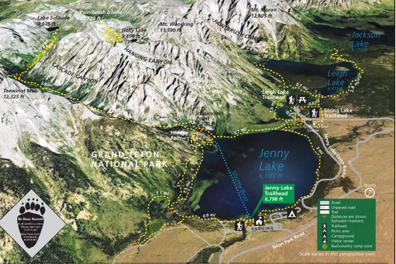
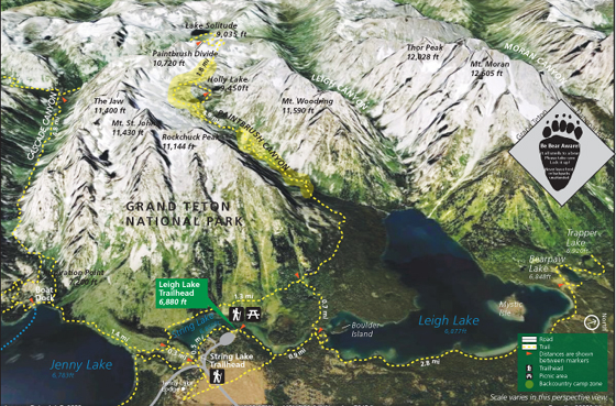
The NPS photo map below shows Jenny Lake, String Lake, Leigh Lake, Paintbrush Divide, Cascade Canyon, Paintbrush Canyon, Hanging Canyon, Mount Woodring, Mount Moran, Teewinot, Holly Lake and Lake Solitude at:
The NPS photo trail map below shows Thor peak, Mount Moran, Mount Woodring, Rockchuck Peak, Mount Moran, Paintbrush Divide, the Jaw, Jenny Lake, Leigh Lake, String Lake, Bearpaw Lake, Trapper lake, Paintbrush Canyon, Leigh Canyon, Cascade Canyon, Moran Canyon, Holly Lake and Lake Solitude
The NPS photo map below has the trails near Laurance S. Rockefeller Preserve and Phelps Lake, Granite Canyon, Open Canyon, Death Canyon, Stewart Draw, Mount Hunt, Fox Creek Pass, Mt. Hunt Divide, Static Peak Divide, Static Peak, Albright Peak, Mt Meek Pass, Death Canyon Shelf, Prospectors Mountain and White Grass Meadow.
![]()
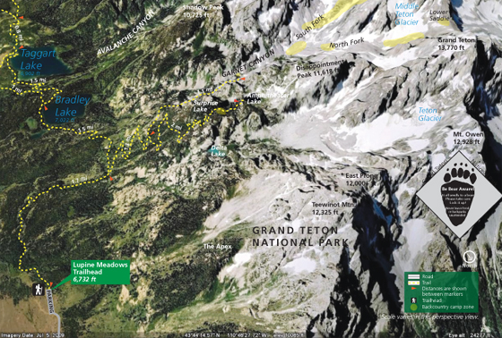
The NPS photo map below, shows the location of Taggart Lake, Bradley Lake, Avalanche Canyon, Garnet Canyon, Stewart Draw, Buck Mountain, Mt. Wister, South Teton, Nez Perce, Middle Teton, Grand Teton, Mt. Owen, and Teton Glacier.
![]()
Printing copies of the photo trail maps above could aid in route finding while hiking, but not substitute for a topographical (topo) map!
Backpackers can find maps of backcountry campsites at Holly Lake, North and South Fork Cascade Canyon, Paintbrush Canyon, Phelps Lake, Granite and Open Canyon, Marion Lake, Death Canyon, Bradley and Taggart Lakes, Garnet Canyon and Surprise Lake at Grand Teton backpacking. And more info at backpacking advice.
—————————–
To be able to answer the question: “what is that mountain named?”
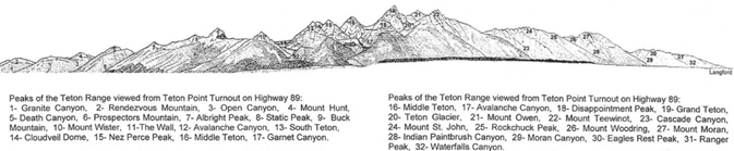
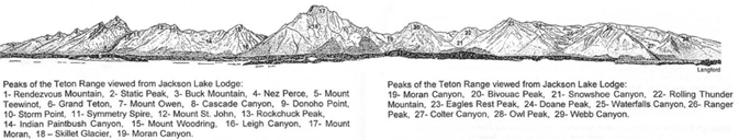
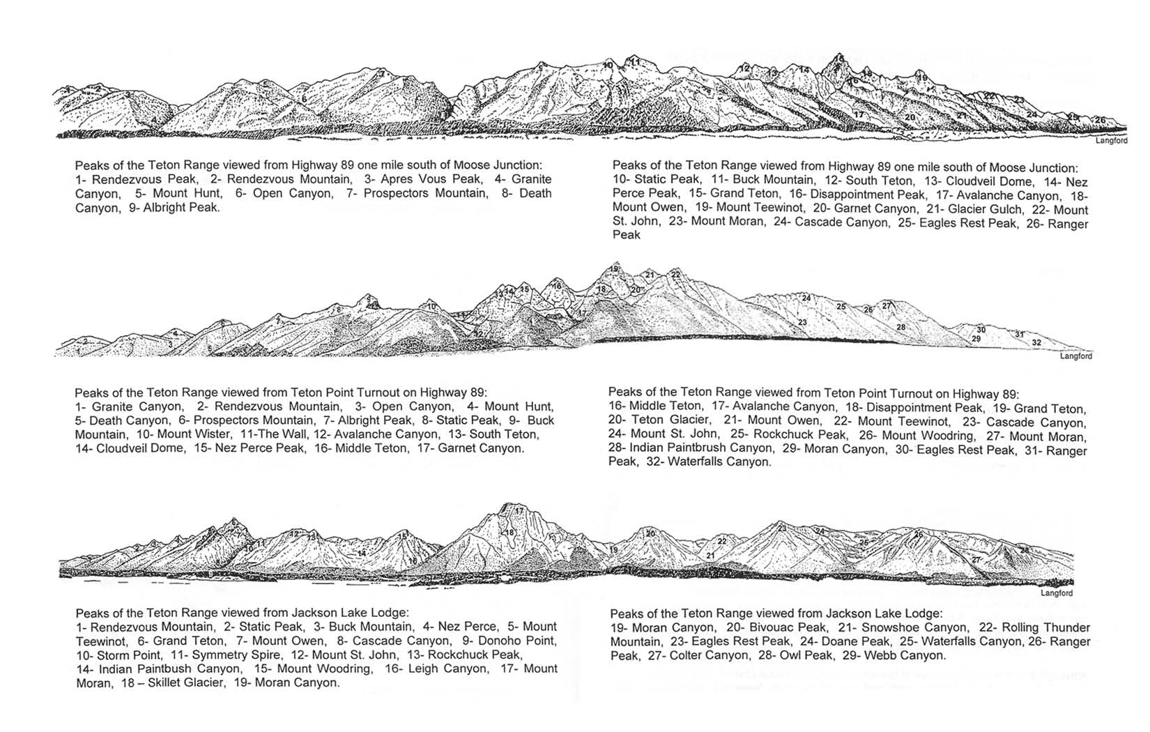
print yourself a larger, more readable copy of these three profile drawings of the Teton Range with the names of peaks seen from these three views:
1) Highway 89, one mile south of Moose Junction
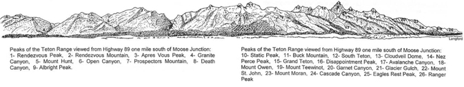
2) Teton Point turnout on Highway 89
3) from Jackson Lake Lodge
go to:
https://www.nps.gov/grte/learn/management/upload/profile.jpg
Here, a webcam looking toward the Teton range at the Craig Thomas visitor center at Moose:
https://www.nps.gov/grte/learn/photosmultimedia/tetonrangewebcam.htm
and the names of the peaks as seen in the webcam or thru the visitor center windows or on the road going thru the entrance station:
—————————–
– – – – – – – – – – – – – – – – – – – – – – – – – – – – – – – – – – –
In the NPS book, A Place Called Jackson Hole, we read:
“From the summit of the Grand, almost every other peak in the range can be seen. The most prominent peak from this viewpoint is Teewinot Mountain, its sharp pinnacles silhouetted against the flat plains of Jackson Hole. The Wind River Range forms the eastern horizon and one can easily pick out flat-topped Gannett Peak, the highest in Wyoming. To the north, one can see well into Yellowstone National Park and beyond, to Pilot, Index, and Granite Peaks. The rolling hills and cultivated fields of Idaho complete the vista to the west.”
Thinking about climbing the Grand Teton?
Here is advice from the Jenny Lake Climbing rangers:
“The Grand Teton is not only the highest peak in the Teton Range but also the high point of climbing activity. From any approach to the range, the Grand Teton towers above the lesser peaks and beckons the climber almost irresistibly. In more than 100 years of climbing on “The Grand” routes to its summit have been found that will satisfy anyone’s taste. From the Owen-Spalding route to the Direct North Face almost all degrees of difficulty can be found. All routes, however, require knowledge of the use of a rope and correct belay techniques to be negotiated safely.
It is not uncommon for parties to take 14 hours or more to make the round trip from the Lower Saddle to the summit and back. The Owen-Spalding and Upper Exum Ridge are often incorrectly described as “hikes.” Soloists have been injured or killed attempting these routes.
Large climbing parties are NOT recommended on the Grand Teton. The Owen-Spalding, Exum Ridge, and Petzoldt Ridge are extremely popular technical alpine rock routes. Groups larger than 2 can cause unnecessary and dangerous delays for all parties on these routes.
Climbers should not attempt a one-day ascent of the Grand Teton without prior experience on this LARGE mountain and familiarity with technical ascents in the Teton Range.
There are no straightforward routes in the Tetons- everything requires good route finding skills!”
http://tetonclimbinggrand.blogspot.com/
![]()
Find a compass, altitude, latitude and longitude on your cell phone
Knowing the elevation you attained on a hike and or climb can be fun for the been-there-and-done-that part of your adventure. Below, a photo taken of the compass app on a cell phone at Lake Solitude, Grand Teton National Park:
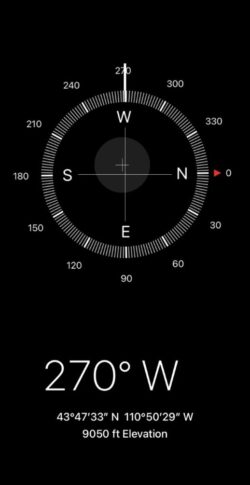
The 270 degrees W (west) shows the direction the cell phone was pointing, useful for orienting to a typographical map.
__________________________________
William O. Owen, (Billy) a surveyor in the Tetons, (for whom Mount Owen was named) was joined by two friends to become the first people to ride a bicycle (said to have rode a Columbia high-wheel) through Yellowstone (in 1883).
__________________________________
See also:
Grand Tetons trip pages index has brief descriptions of most of the pages about the De Anza College trip.
You can stay in a cabin, tent cabin or even a suite with fabulous view, fireplace, fridge, etc. Read more at: Grand Tetons hotels, cabins, lodging
__________________________________
![]()
Some of these webpages with maps and pictures of Grand Teton National Park campgrounds have recommendations for which campsite to choose:
Headwaters campground, near the Yellowstone National Park border, has 100 trailer sites and 75 tent sites.
Lizard Creek campground also has sites on Jackson Lake, some with views.
Colter Bay campground includes 335 individual campsites (160 tent spots with tent pads), 11 large group campsites (by reservation only), 13 electric sites, and ADA-accessible hookups. None of these campsites are on the lake and none have views.
Signal Mountain (86 campsites) is the campground with some sites with views across the lake to the mountains.
Jenny Lake campground, a short distance from Jenny Lake, 49 sites, tents only, one vehicle only less than 14 feet long.
Gros Ventre campground, 4.5 miles from Gros Ventre junction, is the closest campground to the town of Jackson (9 miles +/- Northeast). Sites vary in size and can accommodate RVs up to 45ft. Thirty-six sites have electricity. Ten are ADA compliant with the adjacent restroom being ADA compliant. It has cottonwood trees and sagebrush along the Gros Ventre river. You might see a moose wander through the campground and sometimes can find one along the river.
__________________________________
 Was that a black bear or a grizzly, a coyote or a wolf or a fox we just saw?
 Rocky Mountain mammal size comparisons has photos and comparisons of beavers, squirrels, pika, marmot, elk, moose, bison, fox, coyote, wolf, golden-mantled ground squirrel, chipmunk, Red Squirrel (also known as) Chickaree, Unita Ground squirrels, bobcat, lynx, mountain lion (cougar), pine marten, mountain goats, bighorn sheep, pronghorn, grizzly and black bears, tundra swan, trumpeter swan, adult and juvenile Bald Eagles.
___________________________________
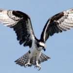
Grand Teton National Park birds has photos and details about the most common ones we can hope to see
including Bald Eagle, Red-winged Blackbird, Canada Geese, Clark’s Nutcracker, Golden Eagle, Great Blue Heron.Great Gray Owl, Harlequin duck, Loon, Magpie, Merganser, Northern Flicker (woodpecker), Osprey, Ouzel, Pelican, Peregrine Falcon, Ptarmigan, Raven, Sandhill Cranes, Steller’s Jays, Trumpeter Swan, Western Meadowlark and Western Tanager, with links to calls / songs from most of them to listen to.
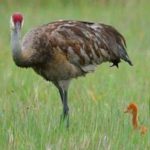
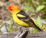
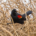
and you can Download photos of over a hundred birds of Grand Teton National Park
https://www.audubon.org/climate/national-parks/grand-teton-national-park

– – – – – – – – – – – – – – – – – – – – – – – – – – – – – – – – – – –
Many people think of trees the shape of the ones shown below as “pine” trees,
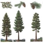
but only one of them is actually a pine tree and we see it in Yosemite rather than in the Rocky Mountains. If you are interested in learning more, see tree identification in Grand Teton Park.
– – – – – – – – – – – – – – – – – – – – – – – – – – – – – – – – – – –
Was that shaking an earthquake? earthquakes, are monitored, with a map of
USGS Magnitude 2.5+ Earthquakes, Past Day
https://earthquake.usgs.gov/earthquakes/map/?extent=21.41216,-129.02344&extent=52.16045,-60.95215
– – – – – – – – – – – – – – – – – – – – – – – – – – – – – – – – – – –
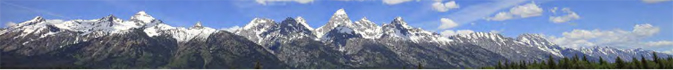
Grand Teton and Yellowstone National Park photos
See also: NASA aerial photo of Teton Range
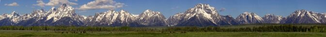
photo above © E J Peiker http://www.ejphoto.com/grand_teton_page.htm used with permission
The author of this webpage, (written for my students), does not give any warranty, expressed or implied, nor assume any legal liability or responsibility for the accuracy, completeness, or usefulness of any information, product, or process included in this website or at websites linked to or from it. Users of information from this website assume all liability arising from such use.