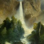
– – – – – – – – – – – – – – – – – – to see WATERFALLS – – – – – – –
using the Yosemite valley free shuttle bus

The Valley wide shuttle bus goes to stops 1 through 19 in that order all day 7 a.m. to 10 p.m. in the summer). The East Valley bus also goes in numerical order all day as well, but to fewer stops.
Read all the details about using the shuttle bus, with more maps.
______________________________________
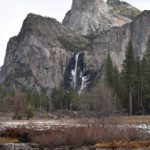
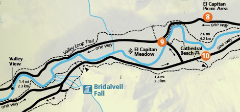
The Yosemite Valley free shuttle bus does not make a stop near
Bridalveil Fall. You must drive to near it and walk to it or hike to it, (the closest shuttle stops are 9 and 10 on the Green Route) but the shuttle does go to a few places you can photograph Bridalveil Fall.
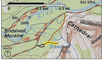
Here, a map of the closest shuttle bus stops to Bridalveil Fall:
Bridalveil Falls can be seen from viewpoint turnouts along Northside Drive on the drive out of the valley (including Valley View on the left hand side of the road just before you leave the valley, about the time you begin to see directional signs for highways leaving the park), at Tunnel View, at the east end of the Wawona Tunnel along the Wawona Road (Highway 41) and by a short walk from a official Bridalveil Falls parking lot on your way into Yosemite Valley, or by taking the shuttle bus and walking down southside drive to the official parking lot.
See details about places to take photos of Bridalveil Fall.
work on restoration of the Bridalveil Fall area.
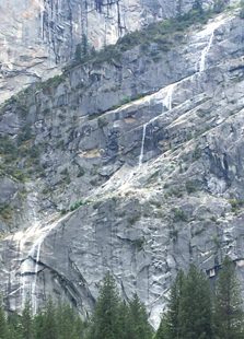
Cascade Falls
is located three miles east of the Arch Rock entrance station, on the left hand side of the road when you drive into the valley, with a parking area just before it on the right hand side. The shuttle bus does not go near there.
Illilouette Fall is not visible from any road; it’s only visible by hiking on steep trails.
Permit (or no permit, depending on the year)
reservation to enter the park (or no reservation needed, depending on the year)
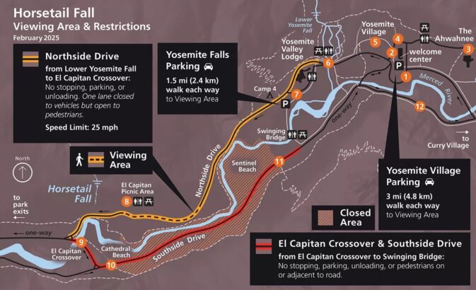
and parking restrictions/ road closures info for viewing Horsetail Fall, at sunset
(and returning to your overnight accommodation after dark)
are at Plan Your Visit horsetail falls
including warnings about safety and a larger copy of a map such as this:
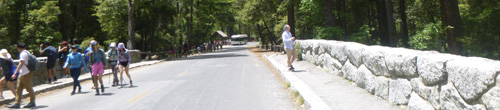
Staircase Fall, (one of the first to dry up after spring flow) comes down from Glacier Point to Curry Village, behind the cabins with bath, and can also be seen at the Curry Village parking, free shuttle bus stops 14 & 19,
and from the back lawn of the Ahwahnee, stop #3
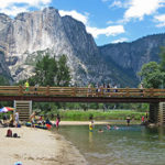
and a boardwalk leads across Stoneman Meadow across the road from the day use parking lot at Curry Village (lower right corner of this photo) to Lower Pines Campground:
With one of the best views of Staircase Falls, here in full flow in May:
—————————
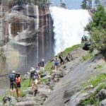
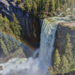
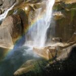
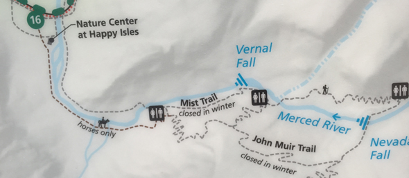
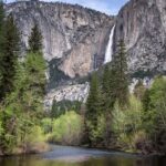
Vernal and Nevada Falls can be seen from Glacier Point (road open only in the summer/fall) or by hiking a trail from Happy Isles, shuttle stop #16.
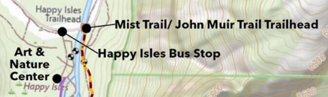
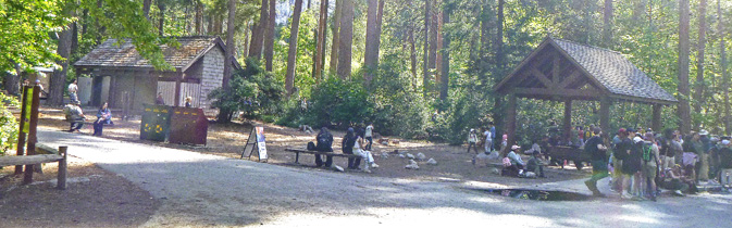
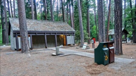
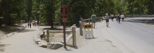
On the bus stop side of the river there are restrooms, a nature center, Art Activity Center with lessons and programs “for artists of all ages and abilities, usually open late March through October), and a fen (marsh).
In the photo below, the restrooms are on the left and bus stop is at the right:
in the photo below, the restrooms are again on the left and the shuttle bus stop is on the right:
In the photo below we see people walking away from the shuttle bus stop towards the Happy Isles bridge and two shuttles at the bus stop:
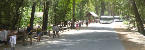
and below, people walking across the Happy Isles Bridge:
after you cross cross the large bridge you can turn right to get to the trailhead for the mist trail (dotted red and yellow line on the map above) and the rest of the John Muir Trail including to Vernal Fall, Nevada Fall, Half Dome and . . . Mount Whitney.
In the photo below, on the right we see people going across the bridge, and on the left, the trailhead (start of the trail):
To hike to Half Dome,
(permit required to go to the top of Half Dome)
you also go to the Happy Isles stop #16. Or rather, to hike to Half Dome and back in one day, get up earlier than the buses run and make your way there.
You can go directly to the trailhead by walking from the Happy Isles bus stop across the bridge and turning right.
A Google street 360 degree view from Glacier Point down to Vernal and Nevada falls, and across to Half Dome.
The Happy Isles Visitor Center (usually not open in the winter) is up a side trail on the other side of the river from the popular John Muir trail and can be easily overlooked, but it is well worth a stop. From the bus stop you would go up a trail alongside the river or the side-road behind the shuttle bus stop.
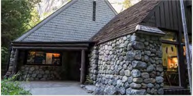
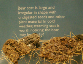
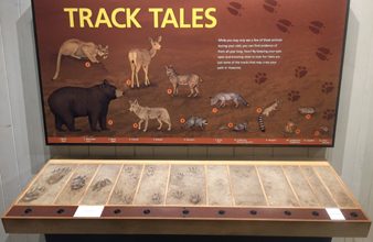
It has natural history exhibits including the animals pictured below, tree and geology explanations.

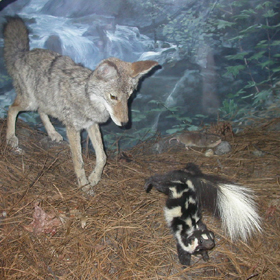
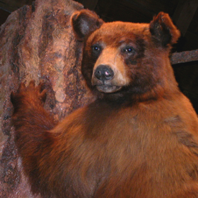
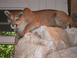
There is a great interactive display with the voices of animals including bear, mule deer, raccoon, mountain lion, ringtail, bobcat, coyote, chipmunk, ground squirrel and more. You can put your paw up next to an impression of an animal paw and compare:
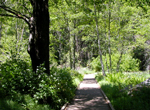
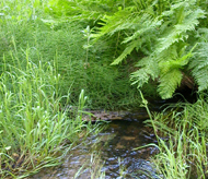
Nearby are short trails focusing on the Happy Isles environment: forest, river, talus slope and the fen (marsh).
Webcam of the river at Happy Isles
There is an outdoor exhibit on the geologic story of rockfalls in Yosemite. A multitude of photos from the October 2008 rockfalls above Happy Isles that eventually closed 233 Curry Village cabins, etc. and 43 staff housing units
Yosemite Valley rockfalls has year-in-review rockfall reports starting with 2008, and rockfall safety tips from the Wilderness Safety Action Team.
________________________________________________________________
Where did they get those photos of Yosemite falls ?
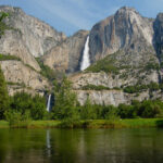
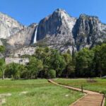
Yosemite Falls
can be seen from many viewpoints in meadows and along roads in Yosemite valley. To walk to the base of lower Yosemite falls, go to shuttle stop #6. To hike to the top of upper Yosemite Falls go to shuttle stop #7.
See details about over a dozen places to take pictures of Yosemite Fall(s) .
Yosemite Conservancy webcam of Yosemite falls
How much water will there be in the Yosemite waterfalls?
To hike to a fairly close-in view of the base of or hike to the top of upper Yosemite Falls Upper Yosemite Fall hike
(2 miles round trip, 1,000 feet elevation gain to Columbia Rock), then on to upper Yosemite Fall (7.2 miles round trip, 2,700 feet elevation gain), Yosemite Point or Eagle Peak (Three Brothers) use the Yosemite Falls day use parking lot/ Yosemite Lodge free shuttle bus stop #7 and head across the main road and through Camp Four.
—————————–
In answer to questions: The Yosemite Valley free shuttle bus does not go to Half Dome, little Yosemite Valley, Vernal Fall, Nevada Fall, Taft Point, Columbia Rock, Clouds Rest or Sentinel Dome
(and you can not drive to them, you must hike to them)
but the shuttle does go to many places you can photograph Half Dome,
or see places to photograph Clouds Rest
——————————————————-
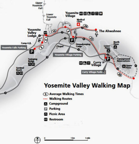
The park service estimates the average walking time (walking directly with no stops for photo taking, to look at scenery/birds, etc.) between bus stops to be:
stop 7 (Yosemite Falls / Yosemite Lodge parking lot) to stop 5 (Yosemite Exploration Center) the walk is 20 minutes. And since the only bus to get on at the Lodge – a Valley Wide -runs the entire length of the route to El Capitan and back, to get to the visitor center or exploration center, the walk from the Lodge could be much faster than taking the bus
stop 1 (Yosemite Village Day use parking lot) to stop 5 (Yosemite Exploration Center, Wilderness Center, museum, Ansel Adams Gallery) the walk is five minutes, and to the biggest grocery, Degnan’s restaurant, the Welcome Center it is such a short walk, that using the bus takes you much more time.
stop 1 (Yosemite Village Day use parking lot) to stop 3 (the Ahwahnee hotel) 25 minutes
stop 1 (Yosemite Village Day use parking lot) to stops 14 & 19 (day use parking in Curry Village) the walk is 25 minutes
stops 14 & 19 (in Curry Village) to stop 16 (at Happy Isles) the walk is 20 minutes
– – – – – – – – – – – – – – – – – – – – – – – – – – – – – – – – – – – – – – – – – –
People at the valley backpacker’s walk-in (for camping the night before and/or after a backpack trip, wilderness permit required are told “you may park for 15 minutes at the entrance to the backpackers’ campground (in the back of North Pines Campground)” to unload gear, and then walk back out and “park overnight at the trailhead parking or at Curry Village day use parking.”
In spring in snowy years, the trail from the back end of North Pines (and over the footbridge) to the backpacker’s walk-in can be flooded with ankle deep or deeper water.
You might find it more convenient to park as directed at Curry Village day use parking, grab your gear and make sure there is no food / toiletries / scented fish bait / old french fries under the seats in your vehicle, get on nearby shuttle bus stop 19, then get off at the Ahwahnee stop #3, (maybe making a stop at the largest Yosemite Valley grocery at stop 2 on the way).
You will find it is a slightly shorter walk from the Ahwahnee bus stop through the parking lot, then make along a paved back road to backpacker’s walk-in campground than from the back end of North Pines IF you can find the way on the back road, but you have a topo map, Yosemite Valley map in the park newspaper, right? And you won’t need to move your vehicle back and forth.
The Ahwahnee stop (#3) would also be a much shorter bus ride from backpackers walk-in to and from the main store, the cafeteria at the Lodge or to visit friends at Camp Four.
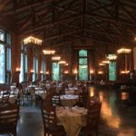
Food choices at the Ahwahnee Bar (less dinner dress code than the dining room)
Chocolate truffles / a multitude of trail snacks are located in the Sweet Shop, across the lobby from the bar. Hotel map.
– – – – – – – – – – – – – – – – – – – – – – – – – – – – – – – – – – – – – – – – – –
![]()
Here, a topographical map with greater detail of the Merced river and meadows in eastern Yosemite valley:
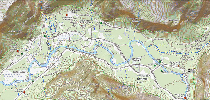
Find topographical maps at National Map.gov
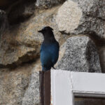
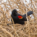
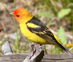
Photos of over a hundred Yosemite birds at a Audubon website
You can download a Bird Checklist which lists all the common and uncommon birds in Yosemite, with bar graphs indicating the “relative abundance of a species in suitable habitat at a given time of year.” And find a listing of special status birds (endangered, species of special concern . . .).
– – – – – – – – – – – – – – – – – – HIKES / TRAILHEADS: – – – – – – –
hiking advice covers hot weather and winter hiking, logistics, blisters, a gear list, GPS is not infallible and more.
A Yosemite Conservancy Naturalist can be hired to lead your choice of a custom hike
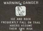
trail conditions It would be wise to ask at a Visitor Center about trail conditions before your hike, but a rockfall could close part of the trail and they would not know about it. In cold weather the trail may also have icy conditions that are not reported. You take your own risks. IF there are any trail closure signs, please follow them.

Bikes and pets are not allowed on unpaved trails, but are okay on paved roads and paved bike paths.
Crane Flat and White Wolf hikes
![]()
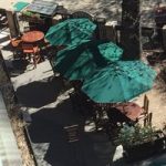
Hotels You have a number of lodging choices of where to stay overnight in Yosemite Valley (wood walled cabin without a bath / heated or unheated wood floored, canvas sided and roofed tent cabin / cabin with a bath / luxury or generic hotel rooms, suites or campsites).
wood-walled cabin without a bath, canvas tent cabin, wood walled cabin with a bath
Hotel room with a bath
You will be offered a copy of the Yosemite Guide newspaper as you pay at an entrance station to enter the park, (or you can read, download or print in advance). It has hours of operation for visitor centers, museums, tours, stores, food service, post office, laundromat, showers, auto service, gas stations, and a calendar of park activities including Ranger walks.
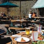
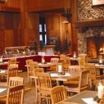
There are restaurants and cafeterias, pizzerias / grill / deli of various sizes and styles at Curry Village, Yosemite Village, the Ahwahnee and Yosemite Lodge. Links to menus for the restaurants are at the bus stop listings for each lodging above and at restaurants. The main grocery at stop #2 has premade individual meal-type salads with dressing packets, and whole or half grilled chickens, plus lots of sliced cheese/meats, crackers/breads, cookies to pack an impromptu picnic from.


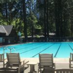
swimming in Yosemite including thunderstorms, bacteria in the water, safety issues, favorite beaches, swimming pools with lifeguards, places you should not swim.
——————————————–
The author of this webpage, (written for my students), does not give any warranty, expressed or implied, nor assume any legal liability or responsibility for the accuracy, completeness, or usefulness of any information, product, or process included in this website or at websites linked to or from it. Users of information from this website assume all liability arising from such use.