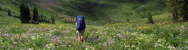

If you decide to backpack overnight in Grand Teton National Park you’ll need a permit. The basic rules are:
individual parties of 1 to 6 people at either specific campsites, or within zones.
Group sites are designated spots for groups of 7 or larger ( up to 12 people at some designated group sites). Maximum occupants varies by site. These are marked by a sign.
There are designated campsites at some places,
zones where overnights are allowed at others
and no sleeping overnight allowed many places, for example, not in the first 4+ miles of the Cascade Canyon trail, or the first 6+ miles of the Paintbrush Canyon trail, on String Lake, Lake Solitude, Emma Matilda Lake or Two Ocean Lake.
There are limits to how many nights you can stay at some places,
as few as two or three nights, and a maximum total in the backcounty in summer.
The park has said:
“Toilet Bags Required for some Trips
The use of a landfill-safe commercial toilet bag system (such as Wag Bag, Restop, etc.) is required for some overnight backcountry trips including high alpine climbing areas and lake sites. Affected permit holders will be required to carry a minimum of one bag per person per night for the duration of their trip and present proof that they have the required number of bags before their permit will be issued. Bags may be available at permits desk but not guaranteed.”
The park says: “Backpackers should expect to travel no more than 2 miles per hour (3.2 km per hour). Add an additional hour for every 1,000 feet of elevation gain. Trip planning that requires going over more than one pass in a day is not recommended.”
Backcountry camping permits are issued to walk-ins on a first-come, first-served basis one day before the start of a trip
(during the peak season, July and August, competition for walk-in permits is high)
OR requests for advance reservations are accepted from early January to (usually) mid-May.
(2024 season opened on January 10 at 8:00am Mountain Time.
2025 peak season (May 1–October 31, 2025) became available beginning January 7, 2025, at 8 a.m. MST.)
Some of the more popular areas fill up within hours of going on sale on the first date.
In a press release we read:
“Effective January 10, 2024, Grand Teton National Park will change the backcountry camping permit fee to $20, plus a $7 per person, per night fee to camp overnight in the backcountry. Grand Teton began charging for backcountry permits in 2014 and last modified the fees in 2018.
Approximately 30% of backcountry camping permits will be available on Recreation.gov for advanced reservations beginning January 10, 2024, at 8 a.m. MST for the 2024 camping season which runs May 1 through October 31. Starting May 1, 2024, the remaining 70% of backcountry camping permits will be available one day before the start of the trip as “walk-up” permits and must be obtained in-person at the Craig Thomas Discovery and Visitor Center, Colter Bay Visitor Center or Jenny Lake Ranger Station permit offices. Advanced reservation permits must be picked up in-person by 10 a.m. the day of the trip or the permit will be cancelled and made available to others.”
– – – – – – – – – – – – – – – – – – – – – – – – – – – – – – – – – – – – – – – – – –
All advance reservations must be done through the Recreation.gov system. Reservations are done “in real time . . .To facilitate your reservation experience, please establish an account on recreation.gov prior to the advance reservation season.”
You will be asked to sign the permit when you pick it up, agreeing to all of the regulations on the permit.
A backcountry ranger could come by where you are overnight and ask to see your permit.
“By signing the backcountry permit, you agree to respect the backcountry.
Read and abide by the backcountry regulations printed on the back of your permit.
Failure to comply may result in fines and revocation of the permit.”
The list you initial could include:
Permits are required for all overnight stays.
The permit is valid only for the location and dates indicated.
Campsite “improvements” such as the construction of rock walls, log benches, tree bough beds, fire rings, and trenches are prohibited.
Fires are permitted only at designated lakeshore sites and only in the metal fire rings provided.
Keep fires small and do not leave them unattended.
Downed and dead wood may be collected.
Gas stoves are encouraged. Pets, bicycles, wheeled vehicles, motorized equipment and explosives including fireworks are prohibited in the backcountry.
Anglers must have a Wyoming State fishing license in possession.
Horse, burro, mule and llama use is limited to established trails and stock camps. Use hitch rails where provided. Carry stock feed; grazing is prohibited.
Short-cutting trail switchbacks is prohibited.
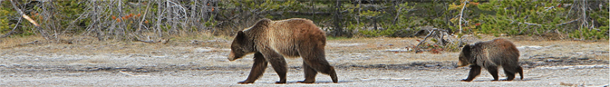
Maintain a distance of at least 100 yards from bears and wolves and 25 yards from all other wildlife. Feeding wildlife is prohibited, interferes with their natural diet and is harmful to their health.
This is bear country. Follow food storage regulations.
Prevent water pollution. Do not wash dishes or bathe in or near streams or lakes.
Carry out all trash and food scraps. If possible, carry out trash left by others. Never bury or burn trash.
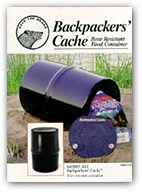
 Where there are no bear boxes, or if you want to bring lots of food and toiletries, you “must take IGBC approved bear resistant food storage containers.” Advice on fitting things in the food containers.
———————————
Read more about regulations at:
https://www.nps.gov/grte/learn/management/lawsandpolicies.htm
———————————
You can download a Grand Teton National Park map to look up all of the back-country campsites detailed below at: http://www.nps.gov/grte/planyourvisit/maps.htm
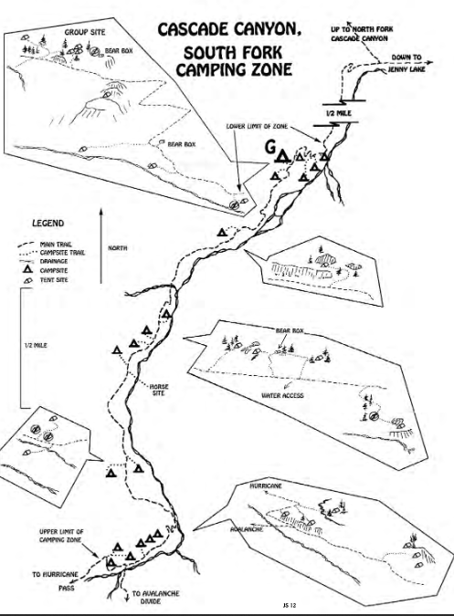
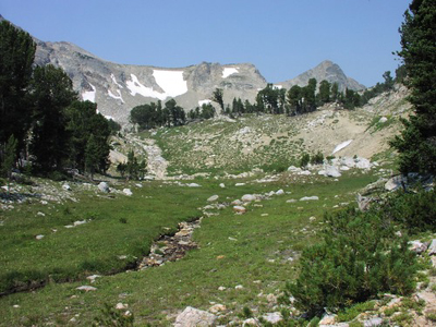
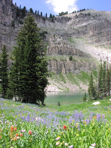
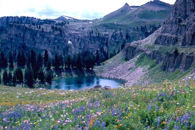
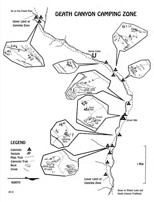
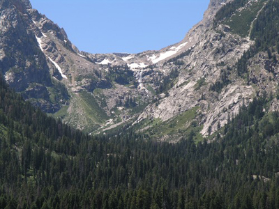
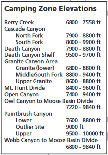
An example of one of the camping zones,
(see detailed maps below of each of the reserve-able campsites)
For your safety hiking, the Rangers warn “… Always carry bear spray and know how to use it… solo hiking and off trail hiking is not recommended, a considerable number of rescues involve solo parties that were unable to self rescue and remained alone in the wilderness, sometimes with life-threatening injuries, until rescuers could locate them.” Your safety in grizzly bear territory
Yellowstone Park offered this video:
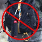
In another park video there was a section on bear spray with this:
![]()
that shows a can of bear spray tucked in the waistband of a backpack.
But we advise people to consider that if they forget it is there and take their pack off quickly,
for example to get at their camera for that great picture,
the can could fall to the ground and even roll down a cliff side.
A can in a harness would be immediately accessible and more secure.
See photos farther down this page of ways to carry – or not carry – bear spray.

Grand Teton National park gets deep snow over the winter, and some years at higher elevations, there is still snow along the trails, or small snowfields to cross even late into the summer.
High elevation campsites can clear up from snow with enough space to pitch a tent in mid to late June, but the bear boxes can remain buried in snow so bear canisters will be required by the park.
When will trails be free enough of snow
to not need the use an ice axe?
In summer, remember that the snow doesn’t clear on the highest trails until late July or even August
and you’ll need an ice axe (and knowledge of its proper use to self arrest and self belay)
for safe travel over many passes/divides.
When you pick up your permit the rangers will give you current details.
A confirmation letter for a permit we got said, in part,
“Safety Check – Do you need an ice axe for your hike?
Snow usually melts from valley trails, approximately 6,700 feet by mid-June but remains in parts of the high country through much of the summer. Safe travel over Paintbrush, Static Peak and Moose Basin Divides and Hurricane, Mt. Meek and Fox Creek Passes requires an ice axe and knowledge of its use as late as August. Snow conditions vary from year to year. If you have questions about the status of these divides as your hiking date approaches call 1 307-739-3309. ”
and at a webpage the Park Service also said:
A descent into Paintbrush Canyon prior to late July requires the use of an ice axe and/or crampons to safely traverse.
Hurricane Pass typically remains snow covered on the Park (east) side until mid to late July and an ice axe is highly recommended to traverse the pass when these conditions exist.”
The Grand Teton Online Ranger Station, with climbing, mountain pass, canyon and trail route conditions is at:
(Yellowstone National Park backcountry conditions)
At the Grand Teton online ranger station you will find info you need to know. Below are examples, for you to compare trail conditions during various years / summer months:
In July, 2010 Lake Solitude was barely melted out and Paintbrush Canyon had a small path shoveled out of its steep snow patch. A backpacker had lost his balance on this steep snow, and broke (open fracture) his leg July 18.
By the end of July 2011, there was still 2-5 feet deep snow at higher elevations and many passes.
In 2012, Lake Solitude started to melt around the edges by June 30, and was open water July 13. By July 13 the north fork of Cascade Canyon was mostly dry and all campsites were snow free. By July 20 only patchy snow remained in the upper portion of Paintbrush Canyon.
By June 4, 2013 the first 4.5 miles of the Cascade Canyon trail had minimal snow, by July 4, 2013 the Cascade Canyon trail was free of snow all the way to to Lake Solitude.
In 2014 the Teton range had its deepest snowpack recorded in 18 years, as much as 500 inches.
by June 8, 2014 there was 60% snow up Cascade Canyon and nearly 100% snow to Lake Solitude.
June 2014 some of the Cascade Canyon trail lower down was completely filled with not-yet-melted snowbanks:
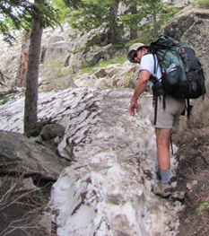
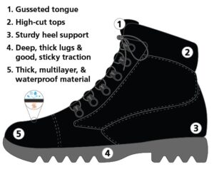
You do still have tread on your hiking boots, yes?
A report of July 28, 2017 said “Alpine terrain in the Teton Range continues to open up as warm summer temperatures work on a snow pack that has proven to be quite stubborn in places. An ice axe remains required to safely traverse Paintbrush Divide and some travelers may want an axe or poles for other sections of the Teton Crest Trail.”
July 10, 2018 Cascade Canyon trails were “Dry to the forks and the beginning of the camping zones North Fork. Some snow free camping in the lower portions of the North Fork. South Fork mostly snow free to end of camping zone. Most campsites in the South Fork are dry.”
July 12. 2019: “With warm temps in the valley, conditions are slowly transitioning from spring to summer in the alpine regions of Grand Teton National Park. However, climbing routes on the Grand still require ice axe, proper footwear (and potentially even crampons depending on the time of day), to safely ascend and descend from the summit. Likewise, visitors expecting dry conditions along the Teton Crest Trail may be surprised to hear that large portions of the trail such as Alaska Basin still remain primarily under snow making navigation difficult. An ice axe and possibly crampons are still needed to safely cross areas such as Hurricane Pass and Paintbrush Divide. In general, expect to find snow in shaded aspects, gullies and bowls in the high country.”
August 16, 2021: “It has been a hot and dry summer, many seasonal creeks are drying up and all the seasonal snow is gone. Many permanent snow fields and glaciers are taking a hit as well. Most mountain routes are dry and in good shape, however, with incoming weather this week things could change quickly. Always be prepared for any weather conditions, it is not uncommon to see extreme temperatures in the mountains this time of year. Any precipitation that falls at the upper elevations could be in the form of rain, hail, or snow.
June 7, 2023: “Rainfall and warming temps this week are accelerating the snowmelt. Depending on which canyon you choose to visit, the first 3-5 miles will be clear of snow. Beyond that, you will find patchy snow eventually leading to all snow.”
May 24, 2023: “The snow continues to rapidly melt but we are still a long way out from summer-like conditions. Trails on the valley floor are a mix of patchy, slushy snow with numerous areas of deeper snow and many down trees. As you move into the heart of the canyons, expect nearly 100% snow cover. A volunteer ranger attempting to reach the Death Canyon Shelf a couple days ago, fell through to his knees immediately after departing the top of the aerial Tram at Jackson Hole Mountain Resort. He was wearing skis!! Travel in the hills is still difficult to say the least. Please be prepared for these conditions and stay safe out there.”
July 22, 2023: “Backcountry trails and popular climbing routes are overall in good condition. Snow levels have receded across the park, and most divides and passes on the Teton Crest Trail are dry. Trekking poles and micro spikes are useful but are no longer necessary across Paintbrush Divide. Buck Mountain Pass, however, still holds a steep snow crossing.”
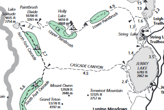
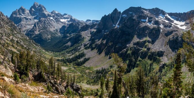
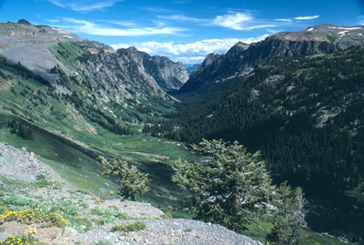
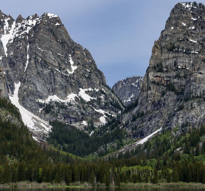
Cascade Canyon:
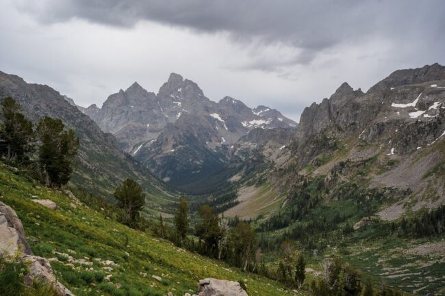
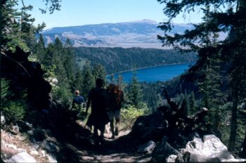
Below we see backpackers on a trail in the North Fork of Cascade Canyon approaching Paintbrush Divide:

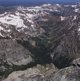
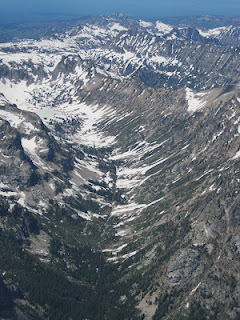
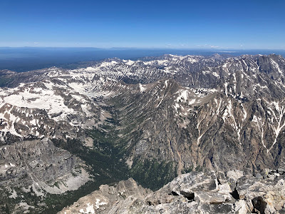
Below, park service photos of the north fork of Cascade Canyon as seen from the summit of the Grand Teton,
to compare July 25, 2010 and June 28, 2012, and below these July 1, 2022.
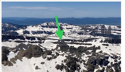
Hurricane Pass separates the South Fork of Cascade Canyon in Grand Teton National Park from Alaska Basin and Teton Canyon. The Park Service offered this photo with an arrow pointing to Hurricane Pass:
NPS photo of Hurricane Pass and Schoolroom Glacier:
![]()
and another NPS photo of Hurricane Pass and Schoolroom Glacier with more snow:
![]()
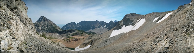
Hurricane Pass and Schoolroom Glacier in August 2023 from the Paintbrush Canyon Trail, photo by Alexandru Dragulescu:
Tetons from Hurricane Pass (NPS photo)
– – – – – – – – – – – – – – – – – – – – – – – – – – – – – – – – – – –
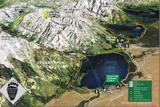
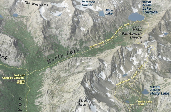
The NPS photo map below shows Jenny Lake, String Lake, Leigh Lake, Paintbrush Divide, Cascade Canyon, Paintbrush Canyon, Hanging Canyon, Mount Woodring, Mount Moran, Teewinot, Holly Lake and Lake Solitude.
– – – – – – – – – – – – – – – – – – – – – – – – – – – – – – – – – – –
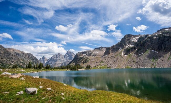
With a permit you can camp up in the far reaches of Cascade Canyon,
but you can not camp at Lake Solitude.
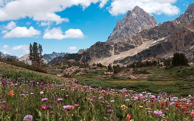
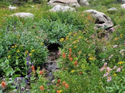
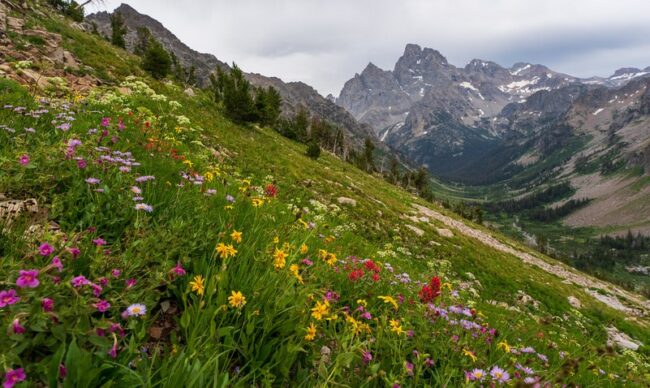
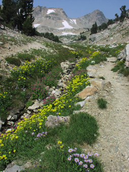
August wildflowers near campsite in upper Cascade Canyon (photo by Mollie Boun)
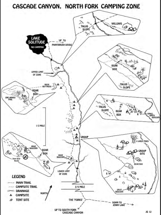
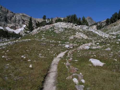
Here are maps of backcountry campsites in the north fork of Cascade Canyon:
and the south fork of Cascade Canyon:
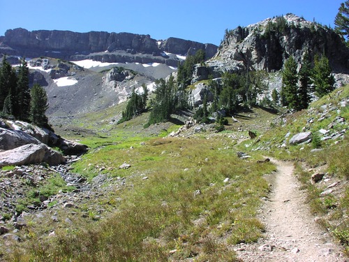
NPS photo of the South Fork Cascade Canyon trail:
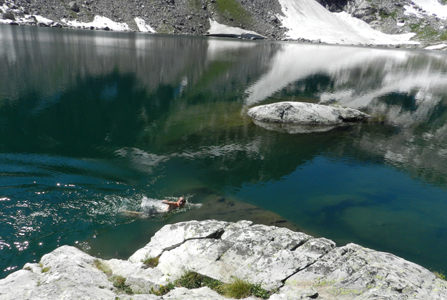
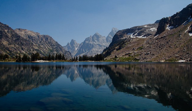
Swimming in Lake Solitude with some snow still along the shore:
Fishing at Lake solitude ( yes, you need a Wyoming fishing license)
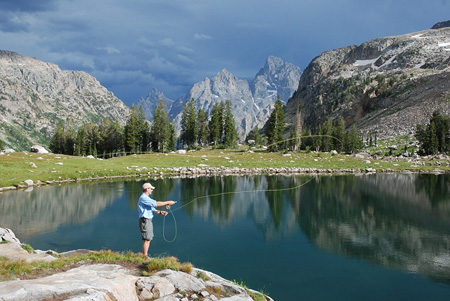
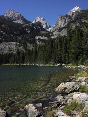
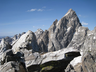
The peaks you see from Lake Solitude are (right to left below) Grand Teton, Mount Owen, and Teewinot Mountain:
Google maps view of Lake Solitude.
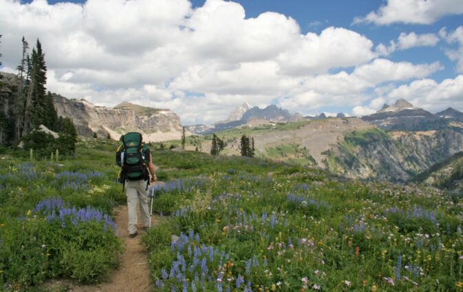
Many people make a long loop that includes Cascade Canyon and Paintbrush Canyon.
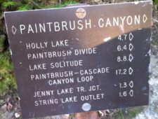
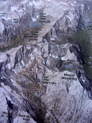
Below: NPS display of part of the trail up to Lake Solitude, over Paintbrush Divide and down to Holly Lake on the Paintbrush Canyon trail.
Here, Cascade Canyon as seen from Paintbrush Divide:
Wildflowers on Paintbrush Divide:
NPS drawing that shows the North fork of Cascade Canyon:
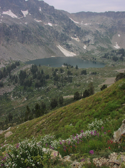
Lake Solitude again and the Paintbrush Canyon trail:
 </p
</p
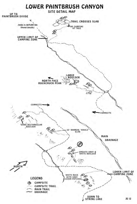
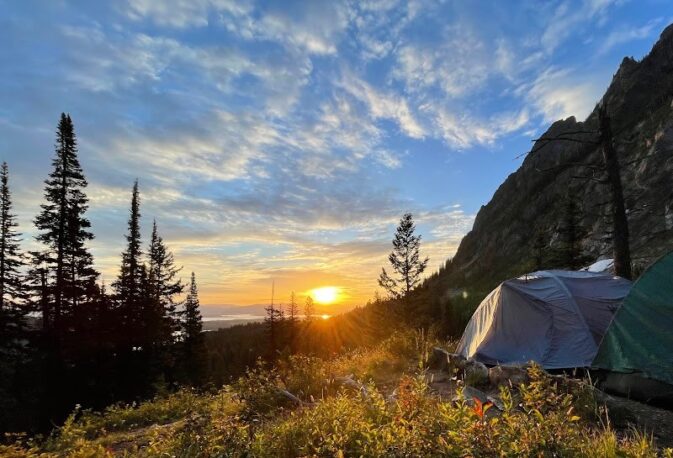
Below, sunrise at a lower Paintbrush Canyon wilderness campsite, described in the map above as having a
narrow, “whale” slab
(photo by Thuy Tien Nguyen)
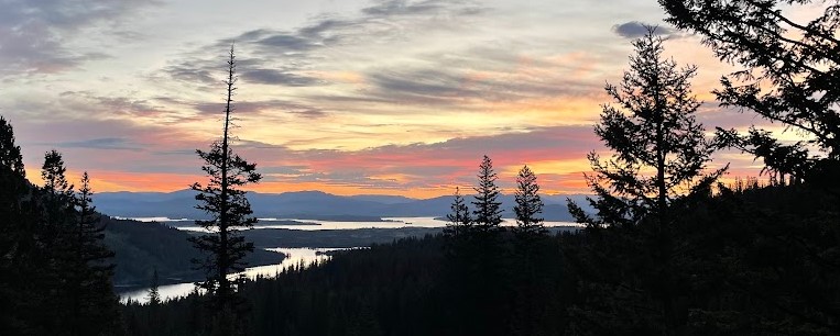
sunset from Lower Paintbrush Canyon looking down at Leigh Lake, Jackson Lake and beyond
(photo by Thuy Tien Nguyen):
Paintbrush Canyon
Google maps view of part of the Paintbrush Canyon trail, and another view.
Paintbrush Divide
The trail sign in the photo below says: Paintbrush Divide 10,200 feet elevation.
Paintbrush Divide trail
– – – – – – – – – – – – – – – – – – – – – – – – – – – – – – – – – – –
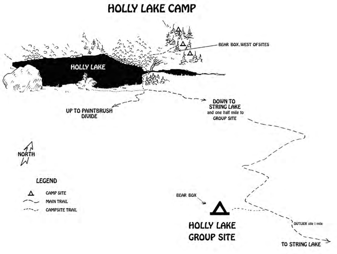
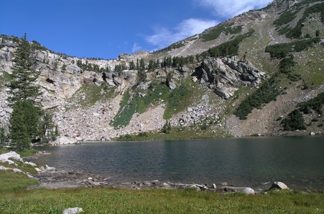
Holly Lake:
– – – – – – – – – – – – – – – – – – – – – – – – – – – – – – – – – – –
The NPS photo map below shows the trails near Laurance S. Rockefeller Preserve and Phelps Lake, Granite Canyon, Open Canyon, Death Canyon, Stewart Draw, Mount Hunt, Fox Creek Pass, Mt. Hunt Divide, Static Peak Divide, Static Peak, Albright Peak, Mt Meek Pass, Death Canyon Shelf, Prospectors Mountain and White Grass Meadow.
![]()
(Please note that the map below is oriented north to south, and the photo map above is not.)
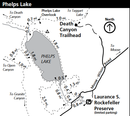
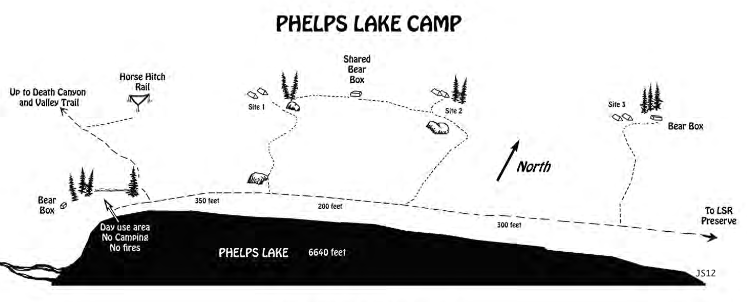
Here is a map of the three wilderness permit campsites at Phelps Lake, (note also the horse hitch rail and day use area).
Google maps view of the north end of Phelps Lake.
Two NPS photos of Phelps Lake from the Death Canyon trail:
![]()
Alaska Basin:
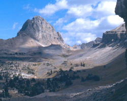
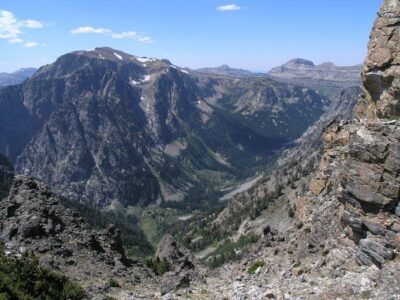
Death Canyon as seen from Static Peak trail
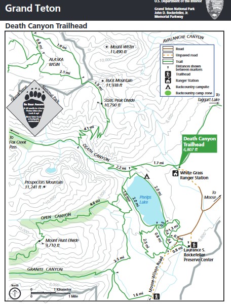
The topographical map below shows the Death Canyon trailhead, with Alaska Basin,
Open Canyon, Death Canyon, Granite Canyon and Phelps Lake trails from the Laurence Rockefeller preserve.
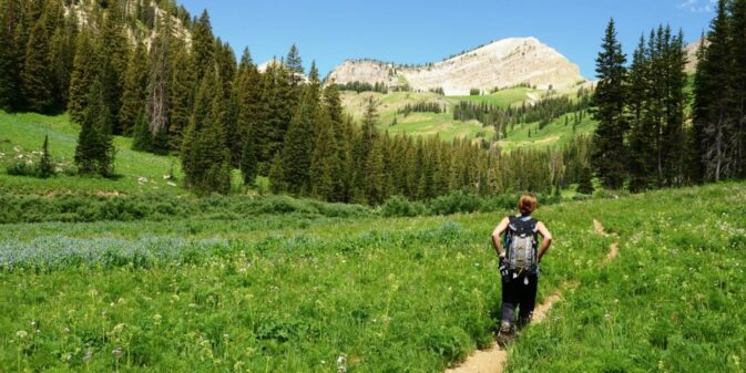
Below, a photo of a hiker on the Granite Canyon Trail:
And here, a park service map of the camping zones in Death Canyon, Open Canyon, Granite Canyon, Mount Hunt
and the trailheads for Death Canyon and Granite Canyon, in relation to the aerial tramway at Teton Village.
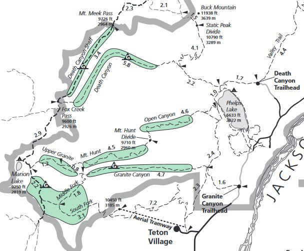
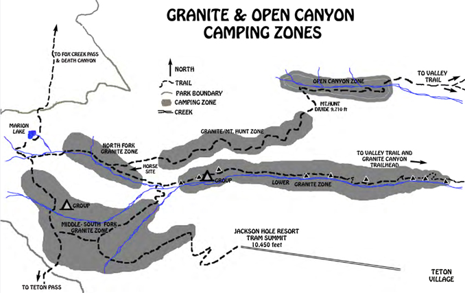
Note Marion Lake in the middle of the left hand side of the map above.
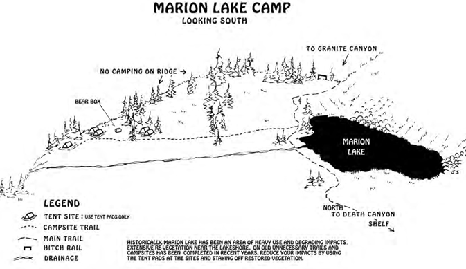
Marion Lake:
Marion Lake:
– – – – – – – – – – – – – – – – – – – – – – – – – – – – – – – – – – –
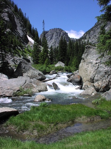
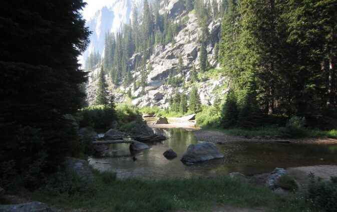
Death Canyon creek:
Death Canyon:
Part of the Death Canyon trail:
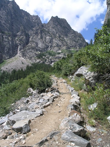
photo below is of the Death Canyon Shelf trail:
and another NPS photo of the Death Canyon trail:
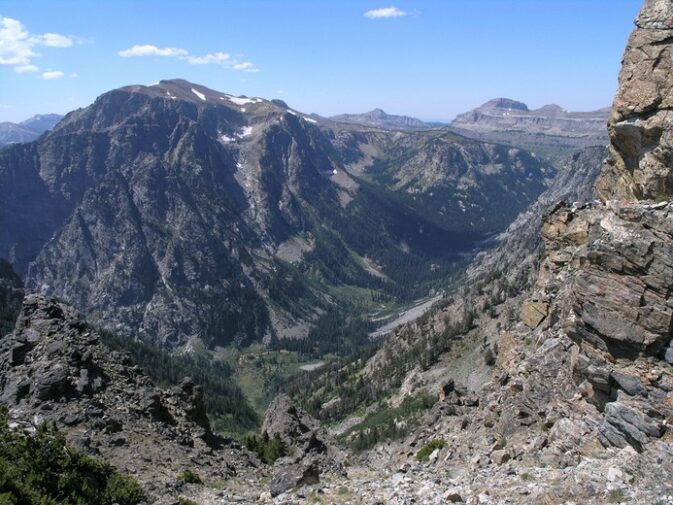
Death Canyon looking east from Death Canyon shelf:
Death Canyon as seen from Static Peak Trail:
Death Canyon as seen from across Phelps Lake:
– – – – – – – – – – – – – – – – – – – – – – – – – – – – – – – – – – –
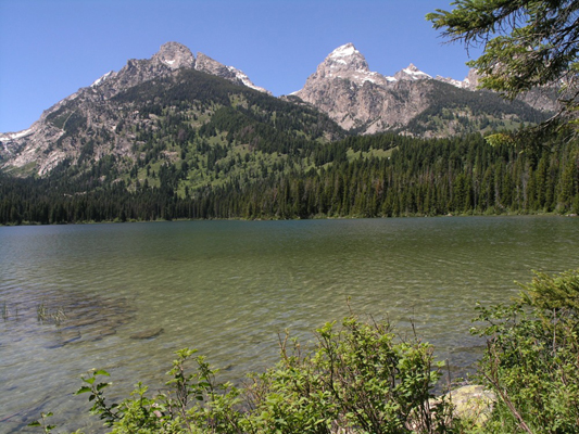
The NPS photo map below shows the location of Taggart Lake, Bradley Lake, Avalanche Canyon, Garnet Canyon, Stewart Draw, Buck Mountain, Mt. Wister, South Teton, Nez Perce, Middle Teton, Grand Teton, Mt. Owen, and Teton Glacier.
![]()
Below, NPS photo of Bradley & Taggart Lakes from the Garnet Canyon Trail:
![]()
and Bradley Lake looking up towards Garnet Canyon:
Google maps view at Bradley lake.
and Taggart Lake with Grand Teton and Nez Perce
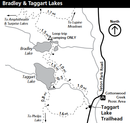
Google maps view trailhead parking lot for Taggart and Bradley Lakes.
– – – – – – – – – – – – – – – – – – – – – – – – – – – – – – – – – – –
Avalanche Canyon:
– – – – – – – – – – – – – – – – – – – – – – – – – – – – – – – – – – –
The NPS photo trail map below, shows Donoho Point, Hermitage Point, Half Moon Bay, Colter Bay, Little Mackinaw Bay, Willow Flats, Pilgrim Creek, Elk Island, Heron Pond, Swan Lake, Cygnet Pond and Colter Bay village streets
![]()
There are campsites on Jackson Lake, including, in the vicinity of the photo map above, a Hermitage Point group site, a 4 mile hike in or boat in; Elk Island boat-in only, and 2 small sites on Little Mackinaw Bay boat-in only:
(Please note that the map below is oriented north to south, and the photo map above is not.)
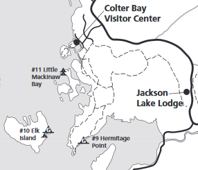
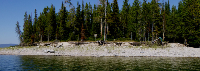
Here, the Little Mackinaw Bay campsite as seen from the water:
(All Jackson Lake campsites require packing out solid human waste.
See also: How to Poop in the woods.)
– – – – – – – – – – – – – – – – – – – – – – – – – – – – – – – – – – –
The NPS photo trail map below shows Thor peak, Mount Moran, Mount Woodring, Rockchuck Peak, Mount Moran, Paintbrush Divide, the Jaw, Jenny Lake, Leigh Lake, String Lake, Bearpaw Lake, Trapper lake, Paintbrush Canyon, Leigh Canyon, Cascade Canyon, Moran Canyon, Holly Lake and Lake Solitude
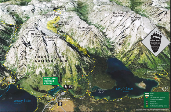
Please note that the campsite map below is oriented to north / south, but the photo map above is not.
Leigh Lake has 7 campsites and one group site. Trapper Lake has 3 sites, Bearpaw Lake has 3 sites.
Leigh Lake 14A, 14B and 16 are boat-in only and along with boat in or hike-in sites 13 and 15 have more privacy than those on the east side of the lake, where the trail goes right next to the #12 campsites, or even right through them and some day hikers “share” the beach right at the campsites, right next to campers tents.
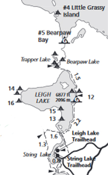
There are campsites on Jackson Lake, including, in the vicinity of the maps above, Little Grassy Island (boat-in only), and a group site on Bearpaw Bay (boat-in only).
For the Bearpaw Lake sites, “most visitors hike in the 3.7 miles from Leigh Lake Trailhead. Boat in is possible for these sites, but you need to beach your boat on the north end of Leigh Lake and walk in a half mile to the campsite.” For the Trapper Lake site, “Boat in is possible for this site, but you need to beach your boat on the north end of Leigh Lake and walk three quarters of a mile to the campsite. Most visitors hike in the 4 miles from Leigh Lake Trailhead.”
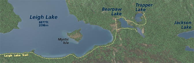
Trapper Lake, with a campsite, is at the far end of Leigh Lake (plus a short hike), 9.2 mile /14.8 km round trip.
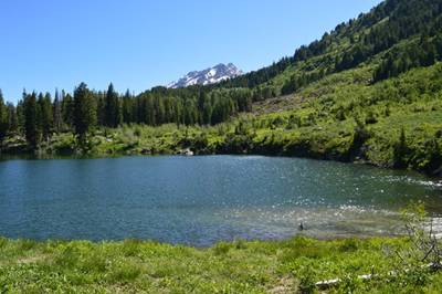
Bearpaw Lake:
– – – – – – – – – – – – – – – – – – – – – – – – – – – – – – – – – – –
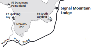
You can drive or boat to the 2 small campsites on Spalding Bay on Jackson Lake. They have bear boxes as well as pit toilets.
Deadman’s Point is boat-in only.
South Landing is small site a mile south of Signal Mountain, boat in or half mile hike in.
South Landing group site a mile south of Signal Mountain, boat in or half mile hike in.
You can boat-in to a campsite on the north-west shore of Jackson Lake at Wilcox Point (can be accessed by either boat across Jackson Lake, or an 8 mile hike from Glade Creek Trailhead which will include a creek crossing.)
or a group campsite and nearby regular campsite, boat-in only on the north-west shore of Jackson Lake at Warm Springs
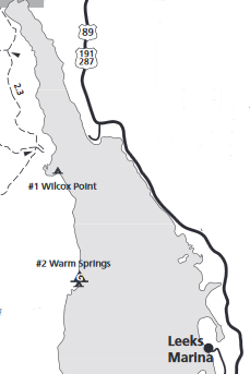
(All Jackson Lake campsites require packing out solid human waste. See also: How to Poop in the woods.)
– – – – – – – – – – – – – – – – – – – – – – – – – – – – – – – – – – –
The NPS photo map below shows Garnet Canyon, Delta Lake, Teton Glacier, Middle Teton Glacier, Disappointment Peak, Grand Teton, Mount Owen, Teewinot, Surprise Lake, Amphitheater Lake, the Apex, Grand Teton lower saddle and Lupine Meadows trailhead
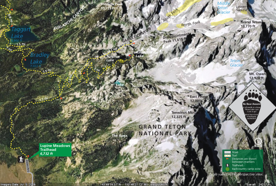
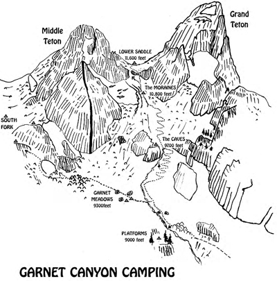
Middle Teton with the black dike, from Garnet Canyon

Ranger and Exum camp on the Lower Saddle:
Special regulations and camping limits apply in Garnet Canyon due to its unique character and the specialized use it receives.
See: https://tetonclimbinggarnet.blogspot.com/
——————————————————————-
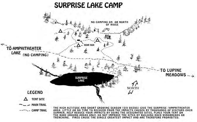
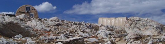
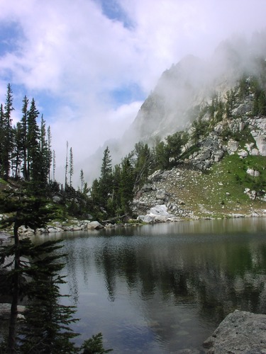
Surprise Lake:
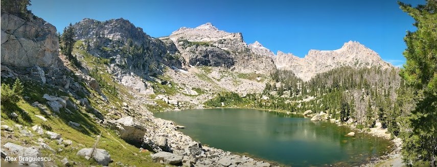
Looking down on Amphitheater Lake – no camping allowed – (photo by Alex Dragulescu)
– – – – – – – – – – – – – – – – – – – – – – – – – – – – – – – – – – –
Printing the photo maps above could aid in route finding,
but not substitute for a topo map!
– – – – – – – – – – – – – – – – – – – – – – – – – – – – – – – – – – –
The main Grand Teton Park backcountry camping page, with the most up-to-date information is at:
http://www.nps.gov/grte/planyourvisit/back.htm
There you can download a backcountry trip planner, find links to camping zones, reservations and more.
– – – – – – – – – – – – – – – – – – – – – – – – – – – – – – – – – – –
At the Grand Teton Climbing Rangers webpages we read:
“The Enclosure (13,280′) The western spur of the Grand Teton, the second highest point in the Teton Range, holds a curious man-made structure within a few feet of its summit. Discovered in the course of the controversial attempt to climb the Grand Teton on July 29,1872, it was originally described as an “enclosure” by Nathaniel P. Langford in his now-famous 1873 article in Scribner’s Monthly. This enclosure consists of an elliptical arrangement of flat rocks placed on edge, 7 by 9 feet across and 3 feet high. This “enclosure” was most likely built by Native Americans at a time ancient or recent (19th century), perhaps as a part of a “visionquest” or other ceremony. Today, the Enclosure not only offers the non-technical climber a summit second only to the Grand Teton, but dozens of multi-pitch alpine and mixed routes for the seasoned alpinist.”
http://tetonclimbingpass.blogspot.com/
– – – – – – – – – – – – – – – – – – – – – – – – – – – – – – – – – – –
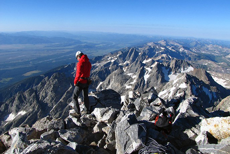
Thinking about climbing the Grand Teton?
Here is advice from the Jenny Lake Climbing rangers:
“The Grand Teton is not only the highest peak in the Teton Range but also the high point of climbing activity. From any approach to the range, the Grand Teton towers above the lesser peaks and beckons the climber almost irresistibly. In more than 100 years of climbing on “The Grand” routes to its summit have been found that will satisfy anyone’s taste. From the Owen-Spalding route to the Direct North Face almost all degrees of difficulty can be found. All routes, however, require knowledge of the use of a rope and correct belay techniques to be negotiated safely.
It is not uncommon for parties to take 14 hours or more to make the round trip from the Lower Saddle to the summit and back. The Owen-Spalding and Upper Exum Ridge are often incorrectly described as “hikes.” Soloists have been injured or killed attempting these routes.
Large climbing parties are NOT recommended on the Grand Teton. The Owen-Spalding, Exum Ridge, and Petzoldt Ridge are extremely popular technical alpine rock routes. Groups larger than 2 can cause unnecessary and dangerous delays for all parties on these routes.
Climbers should not attempt a one-day ascent of the Grand Teton without prior experience on this LARGE mountain and familiarity with technical ascents in the Teton Range.
There are no straightforward routes in the Tetons- everything requires good route finding skills!”
http://tetonclimbinggrand.blogspot.com/
As of 2002, the Park Service was promoting a more complete pack-it-out policy and providing ‘rest stop’ bags to pack out human waste from the Grand Teton lower saddle. Climbing guide companies were requiring their clients to use the bags.
You can climb and day hike without a permit, as long as you don’t camp/bivouac. But it’s always wise to check with the Rangers for info before even a long hike above the valley floor. In 2000 they banned eating snacks or lunch in the Hidden Falls and Inspiration Point areas of Cascade Canyon because a black bear sow and her two cubs had found they could bluff charge and get people to abandon their picnic or pack.
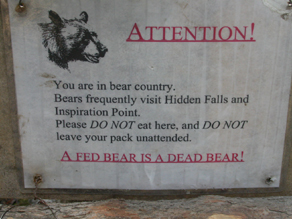
It is wise to keep your backpack or daypack within arm’s reach at all times it is not on your back, if not because of the bears, but also to keep a rodent from chewing into it or a raven from opening the bag and getting into it.
De Anza students planning a backpack as a part of one of our official trips to the Tetons are asked to read: Backpacking Advice, which has these sections: Must bring for each large group (or perhaps for each couple or person), Must bring backpacking for each person, Some (crazy?) people think these are optional for backpacking, Backpacking luxuries(?), Do not bring these backpacking, To keep down on weight backpacking, Don’t rush out and buy, BACKBACKING FOOD, Low-cook backpacking foods, Yosemite National Park WILDERNESS PERMITS, Leave no trace camping has these basic principles.
and to plan to check out one or more Garcia food storage containers from the club advisor.
 using a bear resistant food storage container has how-to info and advice on how to fit more in each container.
If you check out at least one Garcia canister from the club advisor well before the trip you can better plan your packing.
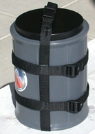
Bear-proof canisters are required for overnight stays where there is no food storage box provided.
Counterbalance hanging of food does not work; bear canisters (or campsite bear lockers, such as those at lakeshore backcountry sites on Leigh, Phelps, and Jackson lakes) are the only effective and proven method of preventing bears from getting human food, and only if the humans use them properly.
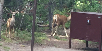
Generous sized campsite food storage box (with deer wandering by) at a backcountry campsite we used:
(Some bear resistant food containers have been invented made of Kevlar, fabric and/or fabric aluminum have been invented, but are not allowed at many parks. Check in advance to see which brands of hard plastic models are okay where you go.)

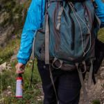
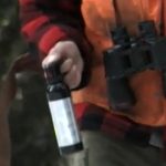
Trip cost includes part of the cost of the bear spray, which is required for everyone to carry. Each trip member is required to attend a ranger program on safe bear spray use and watch an online video and read about bear spray before they go hiking, biking, kayaking or even walking away from developed areas. The ranger programs are offered every day in the summer at at least one Grand Teton National Park visitor center.
In a dozen years of club trips no one has had to use (spray) any bear spray.
Before the trip we usually have people put on their fully-loaded-for-a-long-hike large day pack / backpack, and put a can of bear spray either in a outside pocket or on a harness, and decide which kind they will want to carry.
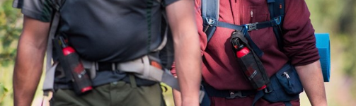
Bear spray should be in easy reach, not hanging from the back side of your backpack,
but it does not need to be out and hand carried.
____________________________________________________
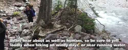
While hiking, talk loudly, sing, shout, clap hands or otherwise make noise on the trail (‘bear bells’ do not work)
The NPS says:
“When hiking, periodically yell “Hey bear!” to alert bears to your presence, especially when walking through dense vegetation/blind spots, traveling upwind, near loud streams, or on windy days. Avoid thick brush whenever possible.”
“Bear bells may be a popular item to put on your backpack, but they don’t effectively warn a bear you’re in the area. Bears won’t hear the bells until you’re too close. Yelling, clapping, and talking are more effective ways of alerting a bear to your presence.”
____________________________________________________
![]()
____________________________________________________
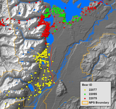
from a NPS report:
the dots represent GPS positions from 3 black bear collars retrieved in Grand Teton National Park:
____________________________________________________
Afternoon thundershowers are common in the summer. At least one period of interesting weather with snowfall at the higher elevations occurs in late August every year. Grand Tetons Weather
Horses and pack trains have the right-of-way. Yield to them by stepping off the trail on the uphill side and stand still and quiet until they are well past you.
_____________________________________________
When you camp at 7,000 or 8,000,or 9,000 plus feet elevation, you will probably feel out of breath at first and may even get a headache and lose appetite. You can get more sunburned. Read At altitude for advice. It includes why your tent mate might seem to stop breathing.
From the Grand Teton National Park backcountry camping brochure:
“Elevations in the park vary from 6,320 to 13,770 feet above sea level. Altitude sickness may strike anyone regardless of age or physical condition. Symptoms include headache, nausea, sleeping difficulties, and tiredness. Plan your trip to allow a slow ascent. Mild altitude sickness may be treated with rest, fluids and aspirin. If conditions persist or worsen, descend to lower elevation.”
“Afternoon thunderstorms are common. Plan your trip accordingly; find a safe place before a storm hits. Avoid exposed summits and ridges, open areas and lone trees. Forested areas with trees of similar height are safer. Do not stand on tree roots. If boating, get off the water.”
“Hypothermia (lowering of body temperature) is a serious condition that may lead quickly to death. Hypothermia is often due to exposure from a storm or a swamped boat. Watch for signs of hypothermia: uncontrollable shivering, incoherent speech and exhaustion. Seek shelter, replace wet clothing and provide warm, nonalcoholic liquids. In serious cases, place the undressed victim in a sleeping bag with another undressed person. Always carry rain gear and extra clothing. Dress in layers and avoid wearing cotton.” And see Wilderness First Aid study guide.
Teton County (Wyoming) Search and Rescue would like you to know:
“Do not stand in moving water, even if shallow. If your foot gets trapped in the rocks, the current will push you over, wedging you foot tighter, and pushing your head underwater. You will drown. Others have drowned in 2 feet of water this way.”
_____________________________________________
Leave no trace camping and hiking has these basic principles:
Plan Ahead and Prepare
Travel and Camp on Durable Surfaces
Dispose of Waste Properly
Leave What You Find
Minimize Campfire Impacts
Respect Wildlife
Be Considerate of Other Visitors
For more details about ‘Leave No Trace’ camping go to:
http://www.tetonclimbingethics.blogspot.com
When you are about to leave, check your campsite and lunch stop for microtrash —look for bandages, twist ties, fruit peels, bits of wrappers, stray potato chips, torn corners of candy bar wrappers and power bars, plastic bottle caps, bits of G.O.R.P. etc. and maybe even pick up what others have left behind.
During any long hike or backpack,
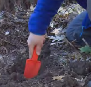
To truly be able to leave no trace and follow backcountry rules about camping the proper distance from a lake or digging your personal latrine hole the proper distance from water, etc., you will need to know how far 100 or 200 feet is. Lay out a tape measure at home and walk it and count your paces.
How to poop in the woods has details.
![]()
Moose use the same trails we hike.
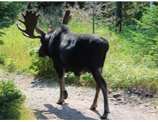
This NPS photo came with this warning:
“when a moose is stressed it will lay its ears back along its head and its hackles will rise.”
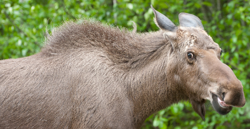
• Denali National park warns: “Moose are not predatory, and they will not try to eat you. Instead, they try to trample a perceived threat.”
A few clues about distances:
about eight miles away the shapes of prominent trees and buildings become distinguishable
about 2 miles away you can see individual windows in a building
about a mile away a person looks like a moving dot without limbs
about 400 yards away (a little under a quarter of a mile) you can make out a person’s legs or a kayaker’s arms
about 250 to 300 yards away faces are discernible (but not recognizable)
![]()
The there is no guarantee of rescue webpage
includes accident prevention tips many people who are experienced hikers and backpackers do not know about.
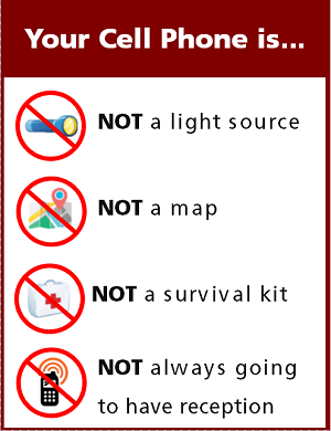 Cell phones in the wilderness has advice on how/when to use a cell phone to contact 911 in the wilderness and a warning about interference between cell phones, iPods and avalanche beacons.
Even though you might not be able to use your cell phone to place a call in many areas of national parks, each person in each hiking group should carry one on each hike.If you each take a photo of all the hikers in your group on your cell phone just before you start a hike, this can be used to document what each person was wearing, maybe quite helpful if someone gets lost.
Search and Rescue can find you better if they know where you are.
IF you have cell phone coverage, you could tell them your location by latitude and longitude.
Find a compass, altitude, latitude and longitude on your cell phone here.
Knowing the elevation you attained on a hike and or climb can be fun for the been-there-and-done-that part of your adventure. Below, a photo taken of the compass app on a cell phone at Lake Solitude, Grand Teton National Park:
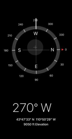
The 270 degrees W (west) shows the direction the cell phone was pointing, useful for orienting to a typographical map.
___________________________________________
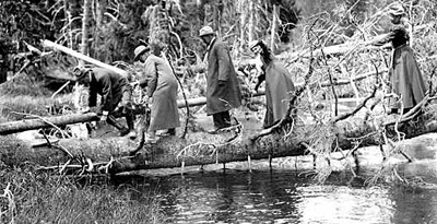
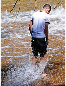
The best place to cross a creek or river is on the bridge built for this endeavor.
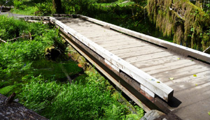
Crossing streams safely includes advice from Mount Rainier National Park, Yellowstone National Park, Great Smoky Mountains, and Yosemite National Park
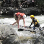
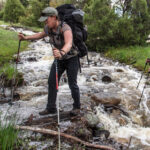
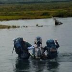
Teton County (Wyoming) Search and rescue would like you to know:
“Do not stand in moving water, even if shallow. If your foot gets trapped in the rocks, the current will push you over, wedging you foot tighter, and pushing your head underwater. You will drown. Others have drowned in 2 feet of water this way.”
Water moving over granite can be moving much faster than you realize and the rock slicker than you think. Below an example of a hiker about to slip and take a fall:
___________________________________________
Enhance your adventure by reading:
Thunderstorm and lightning safety includes the answer to the question: Why can’t you swim during a lightning storm? A strike on a lake doesn’t kill all the fish in the lake.
Backpacking Advice has these sections:
Must bring for each large group (or perhaps for each couple or person),
Must bring backpacking for each person,
Some (crazy?) people think these are optional for backpacking,
Backpacking luxuries(?),
Do not bring these backpacking,
To keep down on weight backpacking, Don’t rush out and buy,
BACKBACKING FOOD, Low-cook backpacking foods,
Yosemite National Park WILDERNESS PERMITS and Half Dome hike advice,
Leave no trace camping has these basic principles.
and see: The day hike gear section at Camping equipment checklist
 You can’t always expect a helicopter rescue
Depending on a GPS unit to intentionally be separated from your hiking partners can lead to confusion or even disaster. Be certain that the people you are with are happy with this prospect. GPS is not infallible
Can a person who is prescribed an epi-pen risk going into the wilderness? and some sting prevention notes are at: Anaphylaxis quick facts
Hiking Advice has hot weather hiking advice, hiking logistics
and the answer to the question: When is the best time of day to cross a mountain stream?
Road trip advice and etiquette
has practical advice from experienced and first-time carpoolers on cross country trips, including
ways to keep from being so bored;
planning before the trip;
safety issues; drowsy driving;
packing;
road trip games, storytelling, debates and discussions;
links to gas price watch sites,
and how to deal with windows that are fogging up faster than your navigator can wipe it off.
See also: animal sign comparisons
(how to use tracks and scat to distinguish species)

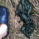
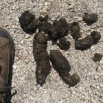
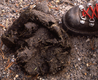
Please do not handle scat. Wolf scat, for example, can transmit tapeworm eggs to humans.
![]()
 Was that a black bear or a grizzly, a coyote or a wolf or a fox we just saw?
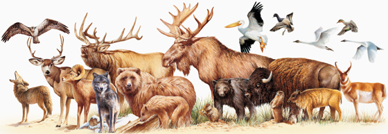 Rocky Mountain mammal size comparisons has photos and comparisons of beavers, squirrels, pika, marmot, elk, moose, bison, fox, coyote, wolf, golden-mantled ground squirrel, chipmunk, Red Squirrel (also known as) Chickaree, Unita Ground squirrels, bobcat, lynx, mountain lion (cougar), pine marten, mountain goats, bighorn sheep, pronghorn, grizzly and black bears, tundra swan, trumpeter swan, adult and juvenile Bald Eagles.
(An elk is not an overgrown deer.)
![]()
Grizzlies in the Grand Tetons, are growing in number.
your safety in grizzly bear territory tells you what to do if
you see a bear in the distance or a bear charges you and has info, including links to park videos about Bear Pepper Sprays.
Camping solutions for women has tips for and answers typical questions from first-time women campers, including the question: Can menstruating women camp or backpack around bears? YES
Bears has links to general info about bears, then practicalities of camping and backpacking around bears, (food storage, what to do if you see a bear) mostly geared towards our trips around black bears in California.
See also Grand Tetons sightseeing
___________________________________
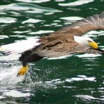

Grand Teton National Park birds has photos and details about the most common ones we can hope to see
including Bald Eagle, Red-winged Blackbird, Canada Geese, Clark’s Nutcracker, Golden Eagle, Great Blue Heron. Great Gray Owl, Harlequin duck, Loon, Magpie, Merganser, Northern Flicker (woodpecker), Osprey, Ouzel, Pelican, Peregrine Falcon, Ptarmigan, Raven, Sandhill Cranes, Steller’s Jays, Trumpeter Swan , Western Meadowlark, and Western Tanager, with links to calls / songs from most of them to listen to.

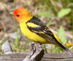

and you can Download photos of over a hundred birds of Grand Teton National Park
https://www.audubon.org/climate/national-parks/grand-teton-national-park

___________________________________
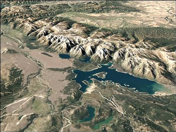
Grand Teton and Yellowstone National Park photos
NASA aerial photo of Teton Range
For details about our next club trip to Grand Teton National Park, go to: Grand Tetons.
Grand Tetons trip pages index has brief descriptions of most of the pages about this trip.
A park brochure listed / suggested these numbers of days for various wilderness itineraries:
“Tram to Granite Canyon via Marion Lake 15.0 miles. Trailhead: Teton Village – 1 night. Fee charged for the tram.
Cascade Canyon/Paintbrush Canyon loop (Note: This is an extremely busy trail July and August) 19.0 miles. Trailhead: String Lake – 1 night.
Granite Canyon/Open Canyon loop via Valley Trail 20.2 miles. Trailhead: Granite Canyon – 1 night.
Tram/Death Canyon loop via Valley Trail 21.9 miles. Trailhead: Teton Village – 1 to 2 nights. Fee charged for the tram.
Cascade Canyon/Death Canyon via Static Peak Divide 25.8 miles (23.4 miles with Jenny Lake ferry). Trailheads: South Jenny Lake and Death Canyon – 1 to 2 nights. Fee charged for the ferry.
Granite Canyon/Death Canyon loop via Valley Trail 24.2 miles. Trailhead: Granite Canyon – 2 nights. Tram to Cascade Canyon via Teton Crest Trail 28.6 miles. Trailheads Teton Village and String Lake. Fee charged for the tram.
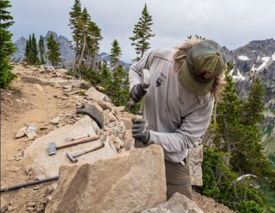
working on rebuilding the Teton Crest Trail for you:
Death Canyon/Cascade Canyon via Teton Crest Trail 30.1 miles. Trailheads: Death Canyon and String Lake – 2 to 3 nights.
Death Canyon/Paintbrush Canyon via Teton Crest Trail 37.1 miles. Trailheads: Death Canyon and String Lake – 3 to 4 nights.
Granite Canyon/Paintbrush Canyon via Teton Crest Trail 38.6 miles. Trailheads: Granite Canyon and String Lake – 4 nights.”
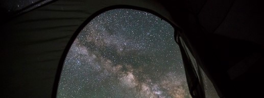
view of Milky Way through tent door:
The author of this webpage, (written as a reading assignment for my students), does not give any warranty, expressed or implied, nor assume any legal liability or responsibility for the accuracy, completeness, or usefulness of any information, product, or process included in this website or at websites linked to or from it. Users of information from this website assume all liability arising from such use.